
Weiherbach (Muckbach)
| Weiherbach | ||
 The Weiherbach shortly before entering a Verdolung under a farm road and the L 578 (2017) |
||
| Data | ||
| Water code | DE : 246922-172 | |
| location |
Tauberland
|
|
| River system | Rhine | |
| Drain over | Muckbach → Brehmbach → Tauber → Main → Rhine → North Sea | |
| source | near Heckfelder Strasse in Dittwar 49 ° 35 ′ 19 ″ N , 9 ° 38 ′ 17 ″ E |
|
| muzzle | on the eastern edge of Dittwar after the L 578 in the Muckbach Coordinates: 49 ° 35 '19 " N , 9 ° 38' 23" E 49 ° 35 '19 " N , 9 ° 38' 23" E
|
|
| length | 171 m | |
The Weiherbach is a brook in the Main-Tauber district in the north of Baden-Württemberg , which flows into the Muckbach from the left near Dittwar . It rises from the Dittwarer Weiher , the source of which is in the village. In the local dialect the pond is also called "Wäid / Wejd / Weed ". Colloquially, this stands for a drinking trough or a wide watering hole.
geography
course
The Weiherbach is the outflow of a small pond with its own source near the Heckfelder Straße on the eastern edge of Dittwar. Immediately after the pond, the Weiherbach first crosses a farm road. It joins the Muckbach after about 0.2 km from the left. In front of its confluence, it enters into a brief dell and passes under a farm road and the L 578, which leads from Dittwar station via Dittwar towards Heckfeld . The Weiherbach drains an area of approx. 0.1 km².
- Weiher and Weiherbach (2017)
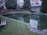
The pond with a covered spring in the background and a drain in the foreground
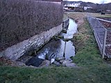
Beginning of the Weiherbach


Brehmbach river system
literature
- Topographical map 1: 25,000 Baden-Württemberg North, as single sheet No. 6323 Tauberbischofsheim West and No. 6324 Tauberbischofsheim East
Web links
Remarks
- ↑ Maninger (1968) describes the village pond as "Wäid"; Walz (1983) calls the terms “Wejd / Weed”.
Individual evidence
- ↑ Heimat- und Kulturverein Dittwar e. V .: Manfred Maninger - Chronicle of the community of Dittwar, 1968 . online at www.hkvdittwar.de. Retrieved February 19, 2018.
- ↑ Dittwarer Mundart - language of the homeland , by Rudolf Walz, published in: 300 Jahre Kreuzkapelle , Lauda, StieberDruck 1983, p. 166.