Wenigbach (Trierbach)
| Wenigbach | ||
|
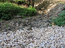
Wenigbach (dry in September 2016) |
||
| Data | ||
| Water code | DE : 271846 | |
| location |
Eifel
|
|
| River system | Rhine | |
| Drain over | Trierbach → Ahr → Rhine → North Sea | |
| source | Southeast of Pomster 50 ° 20 ′ 17 ″ N , 6 ° 52 ′ 5 ″ E |
|
| Source height | 471 m above sea level NHN | |
| muzzle | At Kirmutscheid in Trierbach coordinates: 50 ° 22 ′ 11 ″ N , 6 ° 50 ′ 16 ″ E 50 ° 22 ′ 11 ″ N , 6 ° 50 ′ 16 ″ E |
|
| Mouth height | 320 m above sea level NHN | |
| Height difference | 151 m | |
| Bottom slope | 29 ‰ | |
| length | 5.3 km | |
| Catchment area | 7.211 km² | |
| Left tributaries | Pomster trench | |
| Right tributaries | Dreisbach, Rossbach | |
| Communities | Pomster , Throws ( Kirmutscheid ) | |
|
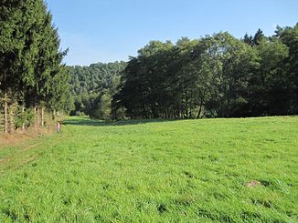
Wenigbachtal near Pomster |
||
The Wenigbach is an approximately five kilometers long right tributary of the Trierbach .
geography
course
The Wenigbach rises between Pomster , Barweiler and Wiesemscheid , in the district of Pomster. The source is 471 m above sea level. NHN on the northern slope of a nameless ridge ( 500 m above sea level ). The stream flows mainly in a north-westerly direction. On its way to Trierbach, it forms the border between Pomster and Barweiler in parts, before it comes to Kirmutscheidermühle near the intersection between federal road 258 and state road 10 and district road 3 at 320 m above sea level. NHN flows into the Trierbach coming from the southwest there.
Catchment area and tributaries
The Wenigbach drains its 7.2 km² catchment area via Trierbach , Ahr and Rhine to the North Sea .
| Surname | GKZ | location | Length in km |
EZG in km² |
|---|---|---|---|---|
| Dreisbach | 2718462 | right | 1,586 | 1.064 |
| Rossbach | 2718464 | right | 0.853 | 1,939 |
| Pomster trench | 27184661 | Left | 0.225 | 0.16 |
| Hard soap | 271846 ?? | right | 0.7 |
ford
At the Wenigbach there is a ford north of Pomster ( ⊙ ).
Individual evidence
- ↑ a b Map service of the landscape information system of the Rhineland-Palatinate Nature Conservation Administration (LANIS map) ( information ) (accessed on December 28, 2016)
- ↑ a b c GeoExplorer of the Rhineland-Palatinate Water Management Authority ( information ) (accessed on December 28, 2016)
- ↑ name by the field names before Gehardtsseifen and Gehardtsseifen
- ↑ There is no information on another right inflow recorded in the map service of the landscape information system of the Rhineland-Palatinate Nature Conservation Administration (LANIS map) ( Notes ) in the GeoExplorer of the Rhineland-Palatinate Water Management Authority ( Notes ), so the length is measured on LANIS.
Web links
- Course of the Wenigbach on the map service of the landscape information system of the Rhineland-Palatinate nature conservation administration (LANIS map) ( notes )
- The Wenigbach with partial catchment areas on the GeoExplorer of the Rhineland-Palatinate water management authority ( information )


