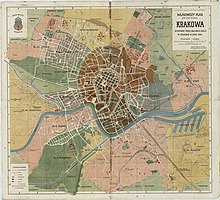
Wesoła (Kraków)
Wesoła is a district of the city of Krakow in Poland , which has belonged to the districts I Stare Miasto ( German 1 Old Town ) and II Grzegórzki since 1990 . When the small-scale urban structure was dissolved in 1973, it came to the Śródmieście (inner city) district until 1990 .
location
Wesoła borders the “Planty” in the west. These denote parks that were created in the area of the abandoned city fortifications. In the north of the district is Warszawskie , east Grzegórzki . The Wesoła district borders Stradom and Kazimierz to the south .
history
The suburb was initially named St. Nikolai after the Nikolauskirche mentioned in the 11th century in the Middle Ages. The Jurydyken, mostly named after noble families, such as Radziwiłłowskie , Morsztynowskie , Lubicz , but also Strzelnica, developed there . The name Wesoła comes from the Vorwerk founded in 1649 by Katarzyna Zamojska . Under this name, the suburb was incorporated into Cracow in 1800 and became a district (Dzielnica) II with Kleparz, and from 1867 to 1947 it became its own cadastral community VI.
The axis of the suburb was the trade route from Kraków through the Nikolai Gate, Mogiła and Sandomierz to Russia (now Kopernika Street).
The municipality had 310 houses with 14,447 inhabitants in the 1900 census, the majority of whom were Polish-speaking (12,993) and Roman Catholic (12,151), but there were also 2004 Jews, 187 Greek Catholics (the largest number in Krakow) and 519 German and 38 Ruthenian speakers.
Wesoła was part of the third district of Grzegórzki from 1948 to 1951.
Architectural monuments (selection)
The district is part of an area that was declared a historical city complex (historyczny zespół miasta) on September 16, 1994 by presidential decree of Lech Wałęsa as a historical monument (Pomnik historii) .
Footnotes
- ↑ The map is not north, north is here on the left.
- ↑ Ludwig Patryn (Ed.): Community encyclopedia of the kingdoms and countries represented in the Reichsrat, edited on the basis of the results of the census of December 31, 1900, XII. Galicia . Vienna 1907 ( online ).
literature
- Leszek Grabowski: Podglądanie starego Krakowa Część VIII. Dawna VI. dzielnica Wesoła , Kraków, 2017 (Polish)
Coordinates: 50 ° 4 ′ N , 19 ° 57 ′ E


