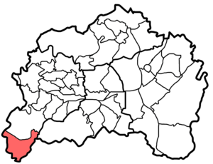
Westhausen (Remscheid)
|
Westhausen district of Remscheid |
|
|---|---|
| Coordinates | 51 ° 9 '7 " N , 7 ° 9' 1" E |
| surface | 2.03 km² |
| Residents | 905 (Dec. 31, 2006) |
| Population density | 446 inhabitants / km² |
| Post Code | 42857 |
| prefix | 02191 |
| Borough | Old Remscheid (1) |
| Transport links | |
| bus | 654 NE13 NE18 |
Westhausen is a district of the city of Remscheid in the Bergisches Land . It is located in the southwest part of the city. The original town center is in the area of today's streets Westhausen and Unterwesthausen .
Location and classification
Westhausen administratively belongs to the city district of Alt-Remscheid . The residential area Küppelstein and the Bodelschwingh settlement belong to the Westhausen district . The city of Solingen joins to the south and west, the city of Wermelskirchen to the south-east and the Reinshagen district to the north . 905 inhabitants live in an area of 203 ha in Westhausen (as of December 31, 2006). The development makes up about 0.3 km², the rest (2.7 km²) are forest areas.
History and structure
Westhausen
Westhausen was first mentioned in writing as Westhusen in 1366 . Further mentions follow in 1369, 1469 and 1487 (all Westhusen ); 1441 ( West Hussen ) and 1513 ( Westhuyßen and Westhuysen ). There was an infirmary near the Westhausen farm until the beginning of the 18th century. A resolution of the government in Düsseldorf on January 26th, 1712 ordered that all infirmaries should be demolished and no new ones should be built. Westhausen was divided into residential areas into the 20th century
- Oberwesthausen 51 ° 8 '52.6 " N , 7 ° 8' 52.5" E
- Unterwesthausen 51 ° 8 '50.4 " N , 7 ° 8' 58.8" E
- Hinterwesthausen 51 ° 8 '57.1 " N , 7 ° 9' 2.2" E
Küppelstein
The Küppelstein farm was first mentioned in writing in 1369 ( Kuppelstein ). Other nominations: 1441 ( Kuppelsteyn ), 1516 ( Kyppelstein ), 1568 ( Küppelstein ). The Küppelstein Castle lay to the north of present-day hamlet Küppelstein. 51 ° 9 ' N , 7 ° 8' E
Breitenplatz
The Breitenplatz residential area was north of Westhausen on today's Westhauser Strasse. The place to live is shown on a map by Carl Friedrich von Wiebeking from 1789 and on a city map from 1930. 51 ° 9 ′ 2 " N , 7 ° 8 ′ 58.1" E
From Bodelschwingh-Siedlung
The Von-Bodelschwingh-Siedlung is not a historical settlement, but was only built in the 20th century. It was built in four construction phases from 1932 to 1959 under the direction of Pastor Gustav von Bodelschwingh . 51 ° 9 ' N , 7 ° 9' E
landscape
Westhausen lies on a mountain ridge running from north to south, the built-up part is at an altitude of 200–244 m. The ridge is surrounded by 100 to 150 meters deep, steeply cut valleys. The northern border to Reinshagen is the Wuppertal-Oberbarmen-Solingen line . To the east the Eschbach flows with the tributaries Kellershammer Bach and Westhauser Bach , to the west the Wupper with the tributaries Schildsiepen and Küppelsteiner Bach . Large parts of the surrounding forest are designated as a nature reserve.
Landmarks and buildings
The Müngstener Brücke , built in 1897, is located in the area of the district. The Academy of Cultural Education of the Federal Government and the State of North Rhine-Westphalia (formerly Remscheid Academy ) is also located in Westhausen (Küppelstein).
Infrastructure
The main street train (Westhauser Straße) runs as Landesstraße 154 on the ridge and meets the B 229 in Vieringhausen .
The VRR operates the bus routes 654, NE13 and NE 18, the nearest train station is Remscheid- Güldenwerth (S-Bahn line S 7, Der Müngstener ).
literature
- E. Erwin Stursberg : Remscheid and his communities , Remscheid, 1969
swell
- ^ E. Erwin Stursberg : Remscheid and his communities , Remscheid, 1969, p. 108f.
- ↑ Remscheid city map, 1930 ( Memento of the original dated October 3, 2006 in the Internet Archive ) Info: The archive link was inserted automatically and has not yet been checked. Please check the original and archive link according to the instructions and then remove this notice.
- ↑ Wolfgang Belitz: Der Lehmbaupastor von Dünne , Hopf-Verlag, Berlin, 2007, ISBN 9783825804695
- ↑ River Area Geoinformation System of the Wupper Association (FluGGS Wupper)

