Old Remscheid
|
Alt-Remscheid (1) City district of Remscheid |
|||||||||||
|---|---|---|---|---|---|---|---|---|---|---|---|
| Coordinates | 51 ° 10 '53 " N , 7 ° 10' 22" E | ||||||||||
| surface | 17.96 km² | ||||||||||
| Residents | 48,933 (Dec. 31, 2008) | ||||||||||
| Population density | 2725 inhabitants / km² | ||||||||||
| Proportion of foreigners | 17.3% (Dec. 31, 2008) | ||||||||||
| politics | |||||||||||
| Allocation of seats (district representation) | |||||||||||
|
|||||||||||
| Transport links | |||||||||||
| Federal road |
|
||||||||||
| Train | S 7 | ||||||||||
| bus | VRS260 615 652 653 654 655 657 658 660 664 670 672 673 675 NE12 NE13 NE14 NE15 NE16 NE17 NE18 NE19 NE20 | ||||||||||
| Source: statistical data | |||||||||||
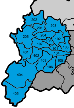
Alt-Remscheid is the most populous district of Remscheid . In terms of area, however, with 1796 hectares, it is smaller than the urban district of Lennep (2746 hectares).
geography
Alt-Remscheid is located in the west of the urban area of Remscheid. In the outskirts of the otherwise very developed urban district there are numerous landscape and nature reserves. The Wupper and the Wupper slopes have been under nature protection since 2001 and are a. known for the 107-meter-high Müngsten Bridge , which is a listed building and is the highest railway bridge in Germany. Upstream the Wupper is bordered by the lower Morsbachtal with the Hölterfelder Siefen and the Fürberger Bach. In the Hammertal you can find extensive oak and beech forests as well as numerous relics of former hammer mills.
structure
|

|
history
Before the then independent cities of Lennep and Lüttringhausen were incorporated into Remscheid on January 1, 1929 , the Alt-Remscheid population was over 3000 hectares and had over 70,000 inhabitants.
In the past, the district of Alt-Remscheid was divided into the districts of city center, north / Hasten and west.
Infrastructure
education
schools
- KGS Julius-Spriestersbach
- GGS Am Stadtpark
- GGS Daniel-Schürmann
- GGS Eisernstein
- GGS Hasten
- GGS Reinshagen
- GGS Siepen
- GGS Steinberg
- Käthe Kollwitz Vocational College
- Ernst-Moritz-Arndt-Gymnasium
- Gertrud Bäumer-Gymnasium
- Albert Einstein Comprehensive School
- Alexander von Humboldt Realschule
- Community secondary school Wilhelmstrasse
- Municipal special school Heinrich-Neumann
- Adult Education Center Remscheid
- Music and Art School Remscheid
- Academy Remscheid
- Evening secondary school in Remscheid
traffic
Road traffic
Alt-Remscheid has no direct connection to the Autobahn 1 . The federal road 229 leads from the district of Remscheid-Süd through Alt-Remscheid to Solingen .
Bus transport
With Friedrich-Ebert-Platz in downtown Remscheid, Alt-Remscheid has most of the bus connections in the city area. There are also lines that go to Wuppertal , Solingen , Wermelskirchen and Cologne .
Rail transport
In Alt-Remscheid, the two railway stations Remscheid Hauptbahnhof and Remscheid- Güldenwerth are on the Wuppertal-Oberbarmen – Solingen railway line . The stations are of the line S 7 ( The Müngstener ) of the train Rhein-Ruhr operated.
Facilities
- District court Remscheid
- Central library of the Remscheid City Library
- Federal agency for work
- Office house
Attractions
Museums
- German tool museum
- Historical center
- Municipal gallery
Buildings
- Cleff House
- Allee-Center in downtown Remscheid
- town hall
- Steffenshammer , Alt-Bergischer Wasserhammer from 1746 in the village of Clemenshammer
- Route of the tool (former railway line RS-Hauptbahnhof - RS- Hasten )
- Teo Otto Theater
Web links
Individual evidence
- ↑ Nature reserves in Remscheid , City of Remscheid.


