White Lick Creek (White River)
| White Lick Creek | ||
|
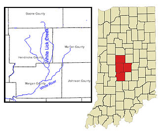
Map of the White Lick Creek |
||
| Data | ||
| Water code | US : 445948 | |
| location | Indiana (USA) | |
| River system | Mississippi River | |
| Drain over | White River → Wabash River → Ohio River → Mississippi River → Gulf of Mexico | |
| source | in Boone County, 39 ° 58 ′ 23 " N , 86 ° 25 ′ 22" W. |
|
| muzzle | at Centerton in the White River coordinates: 39 ° 29 ′ 35 " N , 86 ° 23 ′ 20" W 39 ° 29 ′ 35 " N , 86 ° 23 ′ 20" W.
|
|
| length | 77 km | |
| Catchment area | 753 km² | |
| Drain |
NNQ HHQ |
13 m³ / s 28 m³ / s |
| Medium-sized cities | Brownsburg , Martinsville , Mooresville , Plainfield | |
| Small towns | Fayette | |
|
White Lick Creek in Plainfield, Indiana |
||
The White Lick Creek is a river in the US state of Indiana .
It rises near the small town of Fayette and flows from Boone County through Hendricks County to Morgan County , where it flows into the White River at Centerton .
In the past, the river had different names: East Lick Creek , White Lick River , Whitelick Creek, and Whitelick River .
Web links
Individual evidence
- ^ US Geological Survey. National Hydrography Dataset high-resolution flowline data. The National Map

