
Whitworth (Lancashire)
| Whitworth | |||
|---|---|---|---|
 |
|||
| Coordinates | 53 ° 40 ′ N , 2 ° 10 ′ W | ||
| OS National Grid | SD882185 | ||
|
|||
| Residents | 7500 (status: (2011 Census)) | ||
| surface | 18.1 km² (6.99 mi² ) | ||
| Population density: | 414 inhabitants per km² | ||
| administration | |||
| Post town | Rochdale | ||
| ZIP code section | OL12 | ||
| prefix | 01706 | ||
| Part of the country | England | ||
| region | North West England | ||
| Shire county | Lancashire | ||
| District | Rossendale | ||
| British Parliament | Rossendale and Darwen | ||
| Website: http://www.whitworth.gov.uk/ | |||

Whitworth is a city in Lancashire ( England ). It has had a town partnership with Kandel in the southern Palatinate since 1966 .
geography
The township of Whitworth covers the entire length of the north-south running "Whitworth Valley" (Whitworth Valley) and covers an area of 1840 hectares . The parish area is in the western foothills of the Pennines and is consistently hilly. The Spodden River, which flows through the parish, is one of the tributaries of the Mersey via the Roch and Irwell Rivers .
The parish consists of the hamlets of Healey, Whitworth, Facit and Shawforth, all of which are connected by the valley's main road, the A671 . To the north is the nearest town Bacup , to the south Rochdale .
history
According to tradition, Whitworth was initially on the edge of the vast forest of Rossendale, the border of which is said to have been at Bacup. The settlement in the Neolithic and Bronze Age is very well documented by archaeological finds, there are only a few finds for the Iron Age and the Roman Age . From the beginning of medieval records, Whitworth is not a separate parish, but belongs to neighboring Rochdale. These records also show that one of the greatest landowners was Whalley Abbey . The economy in the Middle Ages was mainly based on agriculture and livestock. There was also a small local iron processing facility.
Land use began to change in the early 15th century, forests declined, sheep husbandry and wool processing increased, and coal mining is documented in isolated cases.
In the 19th century, after the road through the valley was built, there was a rapid industrial development, quarries, coal mines and textile processing companies were built.
Buildings
There are some listed buildings in the community, none of which are of national importance.
population
Whitworth's population peaked at 9,574 in 1901 and beyond, but then declined as a result of the recession in the 1930s and the aftermath of World War II . The first post-war census in 1951 found a population of 7442 inhabitants, which continued to shrink to 7,031 by 1961. Since then the population has risen to the present level of 7700.
Infrastructure
From 1881 to 1947 Whitworth had a rail connection to Bacup and Rochdale. Since the end of the 19th century there have been two reservoirs, which mainly serve to improve the water supply. There are four primary schools and one secondary school in the village. The parish is touched by the Pennine Bridleway .
administration
To administer Whitworth, a local authority was set up in 1871, which was converted in June 1894 into a town council for the then completely independent parish. With the reorganization of local government in England in 1974, the local council ("Urban District Council") was abolished and by the city council of Whitworth ("Whitworth Town Council") within the newly created city council of the district of Rossendale ("Rossendale Borough Council") replaced.
economy
There are still unused or converted buildings for the textile industry throughout the local area. In the 2010s there was still a large proportion of commercial jobs in the town, but the service sector and the skilled trades employ the majority of the population.
Others
In April 1976, an area in and around Healey Dell at the southern end of the valley was designated a nature reserve, the only one in Rossendale. This area represents a combination of valuable ecosystems with traces of the industrial revolution. A well-known remnant of the old railway infrastructure is the 30 m high Healey Dell Viaduct .
The former mayor of the German twin town Kandel, Oskar Böhm is one of Whitworth's honorary citizens.
photos

The Church of St. Bartholomew
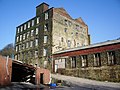
Former industrial building
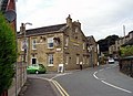
Houses on Tong End Road

The road Cowm Park Way

The Cowm Reservoir above the village
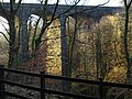
Healey Dell Viaduct


literature
- William Farrer, J. Brownbill: A History of the County of Lancaster . tape 5 , 1911, pp. 187–201 ( online [accessed March 1, 2019]).
Individual evidence
- ↑ a b Local Area Report for Whitworth on the information system nomisweb of the Office for National Statistics ; accessed on February 28, 2019.
- ↑ a b c d e f g h Overview of the history of the community on the homepage. Retrieved March 1, 2019.
- ↑ a b c Introduction to Archeology and Whitworth's Early History on Archaeological Discoveries in South-East Lancashire. Retrieved March 1, 2019.
- ↑ Medievel Whitworth on "Medieval documentation for Salford Hundred" (Engl.). Retrieved March 1, 2019.
- ↑ List of listed buildings in Whitworth on the National Heritage List for England . Retrieved March 1, 2019.
- ↑ Whitworth's population development from 1901 to 1961 on A vision of Britain . Retrieved March 1, 2019.
- ↑ Presentation of leisure activities on visitrossendale.com . Retrieved March 1, 2019.
- ^ History of the Whitworth Valley Administration . Retrieved March 1, 2019.
- ↑ Description of Whitworth on visitlancashire.com . Retrieved March 1, 2019.
- ^ Description of Healey Dell on the Woodland Trust website . Retrieved March 1, 2019.
- ^ Description of Healey Dell on the website visitrochdale.com . Retrieved March 1, 2019.
- ^ List of Honorary Citizens of Whitworth. Retrieved March 1, 2019.
Web links
- Whitworth on A vision of Britain