Wielands (municipality of Grafenschlag)
|
Wielands ( village ) locality Wielands cadastral municipality Wielands |
||
|---|---|---|
|
|
||
| Basic data | ||
| Pole. District , state | Zwettl (ZT), Lower Austria | |
| Judicial district | Zwettl | |
| Pole. local community | Grafenschlag | |
| Coordinates | 48 ° 30 '21 " N , 15 ° 7' 34" E | |
| height | 780 m above sea level A. | |
| Residents of the village | 40 (January 1, 2020) | |
| Area d. KG | 2.22 km² | |
| Statistical identification | ||
| Locality code | 06780 | |
| Cadastral parish number | 24295 | |
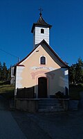
 Wieland's local chapel |
||
| Source: STAT : index of places ; BEV : GEONAM ; NÖGIS | ||
Wielands is a village and a cadastral municipality in the Grafenschlag municipality in the Zwettl district in Lower Austria . The place is about 780 meters above sea level west of Grafenschlag north of Guttenberg .
He was mentioned in writing for the first time in 1456 as "Wielants" and refers to a local founder named Wieland . It originally belonged to the rule of Weitra and then came to the rule of Ottenschlag . After 1850 the place was part of the municipality of Kleinnondorf and after its dissolution on January 1, 1967, it became part of the greater municipality of Grafenschlag.
Attractions
- Local chapel from the 18th century

