Grafenschlag
|
market community Grafenschlag
|
||
|---|---|---|
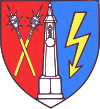
| coat of arms | Austria map | |
|
|
||
| Basic data | ||
| Country: | Austria | |
| State : | Lower Austria | |
| Political District : | Zwettl | |
| License plate : | ZT | |
| Surface: | 34.15 km² | |
| Coordinates : | 48 ° 30 ' N , 15 ° 10' E | |
| Height : | 780 m above sea level A. | |
| Residents : | 854 (January 1, 2020) | |
| Postal code : | 3912 | |
| Area code : | 02875 | |
| Community code : | 3 25 06 | |
| NUTS region | AT124 | |
| Address of the municipal administration: |
Grafenschlag 47 3912 Grafenschlag |
|
| Website: | ||
| politics | ||
| Mayor : | Franz Heiderer ( ÖVP ) | |
|
Municipal Council : ( 2020 ) (15 members) |
||
| Location of Grafenschlag in the Zwettl district | ||
| Source: Municipal data from Statistics Austria | ||
Grafenschlag is a market town with 854 inhabitants (as of January 1, 2020) in the southern Waldviertel in Austria .
geography
Geographical location
The place is a typical rural village , but there are already some new settlements on the edge of the municipality. South of the village flows Purzelkamp , one of the tributaries of the Kamp flow , in a westerly direction.
Community structure
Grafenschlag is divided into the main town Grafenschlag (395 inhabitants) and the cadastral communities (number of inhabitants in brackets as of January 1, 2020):
- Bromberg (first mentioned in 1273, 35 inhabitants)
- Kaltenbrunn (first mentioned around 1200, 75 inhabitants)
- Kleingöttfritz (first mentioned in 1321, 66 inhabitants)
- Kleinnondorf (first mentioned 1380, 105 inhabitants)
- Langschlag (first mentioned in 1321, 43 inhabitants)
- Schafberg (first mentioned in 1286, 95 inhabitants)
- Wielands (first mentioned in 1456, 40 inhabitants)
there are also some individual farms such as:
- Pond courtyard
- Dachelhof
- Wedge mill
- Ödhof
- Sattelhof
- House yard, house mill
- Nagelhof
- Gallmill
Incorporations
On January 1, 1967, the local parishes of Grafenschlag and Kleinnondorf merged to form one large parish after a resolution of September 3, 1966, and on January 1, 1970, the parish of Langschlag and the individual location Rammelhof were added.
Neighboring communities
| Rappottenstein | Grossgöttfritz | |
| Schönbach |

|
Sallingberg |
| Bad Traunstein |
history
The place was mentioned for the first time in 1321 as marchtmuel iuxta Grevenschlag (even then as a market town). In the Middle Ages, the fortunes of the place were tied to the Guttenberg rule , a Gozwinus de Gutenberch (counted among the Kuenring fief knights ) had a strategically important fortress built on the Guttenberg (855 meters) west of the community , according to a document from Heinrich II. At the end of the 13th century, the knightly Tehler family lived in the castle.
Then the facility fell into disrepair and a Zdenko von Sternberg had a ski jump built on its remains . That Zdenko then fought against the Bohemians at Gratzen Castle (Nové Hrady in Czech) in 1467 , which in turn devastated the place in 1478 and 1480. The White Sunday of 1480, on which fear and terror reigned in the village , is particularly well known . Around this time a market court was established in the village and in 1566 the Freihaus zu Gräffenschlag was already united with the Ottenschlag rule .
On February 19, 1597, the place is a meeting point for 30,000 rebellious farmers from the Waldviertel. The rebels then gathered in the field between the house mill and the village and later this was the place of negotiation between the peasants and the imperial commissioners. An Andreas Schrembser from Dobersberg leads the negotiations, but they remain unsuccessful and so the bloody peasant wars in the Waldviertel come to an end when the peasants are defeated by the imperial troops near Neukirchen am Ostrong .
From 1619 Grafenschlag was also involved in the conflicts in the Thirty Years' War , the church, the rectory and the market served man and horse as quarters . A quiet period of development followed from 1667 when the place came into the possession of Ferdinand Ernst Graf von Herberstein . Among other things, he waives the state tax for farmers who were completely impoverished by the war. This development was only stopped by the Napoleonic Wars from 1805 ( Battle of Dürnstein ), a division of French men who had penetrated to the site was billeted. The town was also influenced by the revolutions in 1848 and the German War in 1866. In 1878 a gendarmerie post was set up in the village, and in 1894 the pillory, which was destroyed by lightning on July 15, 1824, was restored.
On October 15, 1906, Grafenschlag was then connected to the Austrian rail network (as a branch line to the Franz-Josefs-Bahn by the Schwarzenau – Zwettl – Martinsberg local railway ).
Although the First World War also cost a few victims among the male residents of the place, a far greater catastrophe struck the place on March 18, 1921, the painful Friday . The place burned down almost completely, only six of the 52 houses remained undamaged, there were also 2 fatalities. Thanks to generous donations from all parts of Austria and the United States of America, the place could be rebuilt quickly, only 1 courtyard was no longer rebuilt.
In 1926 a weighbridge was erected on the market square, at the turn of 1926/27 the place got its first telephone connection, from autumn 1932 the place was finally electrified.
In the course of an administrative reform, the place came to the administrative district Zwettl in 1939 , in the same year the Second World War began , 87 male residents of the place lost their lives in the Wehrmacht .
On May 9, 1945, the site was occupied by Soviet troops, who remained in Austria until the end of the occupation in 1955.
In the post-war period there was a great deal of reconstruction work in the village, and Grafenschlag increasingly lost its character as a market and farming community, as agriculture itself was subject to major changes. 1956 the place is connected to the sewer system and the main road running through the place is paved. In 1958 the fire station was built, and in 1963 the first local water pipe was installed. As early as 1961, the pillory was moved to its current location by the local beautification association.
Despite the population decline, a new elementary school was inaugurated on September 24, 1978 , which in turn was rebuilt from 2000 to 2002 and reopened on June 8, 2002 in the presence of Regional Councilor Wolfgang Sobotka .
In order to counteract the continuing decline in population, new building sites were developed in the east of Grafenschlag on the road to Kaltenbrunn from 1985, the so-called "settlement" was built here increasingly from 1990, also on the western edge of the village and, increasingly, since 2007, new residential buildings have also been built in the north. After trial operation of a local water pipeline began at the end of 1988, it was finally put into operation in 1991. A sewage treatment plant was also built in 1995. The gendarmerie post, which has existed in the village since 1895, is closed on August 1, 1990 after previous protests by the population, but the vacant rooms can quickly be taken over by the municipal office and used for its expansion. A renovation of the entire office building was completed on October 31, 1999.
Population development
| census | Residents |
|---|---|
| 2011 | 876 |
| 2001 | 893 |
| 1991 | 870 |
| 1981 | 1048 |
| 1971 | 1109 |
Source: Population development from Grafenschlag. (PDF) Statistics Austria
Culture and sights
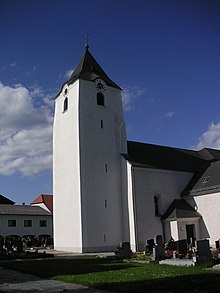
- Parish church Grafenschlag : The originally late Gothic church received a modern nave in 1976.
- Pillory from the Renaissance ( 17th century ), with a crowned obelisk of granite was smashed in 1824 by a lightning strike.
Economy and Infrastructure
traffic
The place is on Zwettler Strasse .
politics
Municipal council
Until 1995 the municipal council had 19 seats, but as a result of the population decline this number was reduced to 15 seats.
- Since the last municipal council election in 2020 , the municipal council has the following distribution:
- ÖVP 12
- SPÖ 2
- FPÖ 1
mayor
- until 2010 Engelbert Heiderer (ÖVP)
- 2010–2019 Robert Hafner (ÖVP)
- since 2019 Franz Heiderer (ÖVP)
Personalities
Sons and daughters of the church
- Sylvester Zeininger (1887–1973), politician ( CSP )
Personalities associated with the community
- Othmar Zaubek (1949–2014), local history researcher and science journalist
literature
- Alois Mitterauer, Othmar KM Zaubek: A short local history of the market town of Grafenschlag. Publication on the occasion of the awarding of the municipal coat of arms on September 24, 1978, Grafenschlag 1978.
Web links
- 32506 - Grafenschlag. Community data, Statistics Austria .
- www.grafenschlag.at , homepage of the municipality
Individual evidence
- ↑ http://www.grafenschlag.at/system/web/ffekten.aspx?menuonr=218851532
- ↑ https://www.data.gv.at/katalog/dataset/land-noe-katastralgemeinden-no
- ↑ Statistics Austria: Population on January 1st, 2020 by locality (area status on January 1st, 2020) , ( CSV )
- ↑ http://www.grafenschlag.at/system/web/zusatzseite.aspx?menuonr=219066050&detailonr=219562404
- ↑ https://www.noen.at/zwettl/ruecktritt-in-grafenschlag-heiderer-als-neuer-ortschef-grafenschlag-robert-hafner-franz-heiderer-142372925


