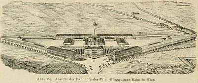
Vienna Gloggnitz train station
The Gloggnitzer Bahnhof , also referred to as the 1st Südbahnhof in the history of the railway in Vienna , was a terminus in the south of Vienna . With the immediately adjacent Raaber Bahnhof , later the State Station, then the Ostbahnhof, it formed a traffic junction that was dominated by the (3rd) Südbahnhof from 1956–2009 and whose functions were gradually taken over by the new Vienna Central Station from 2013–2015 .

Location in the city area
The first at the gates of the walled Wien resulting Station was on the 1838 Leopoldstädter Danube Island opened North Station . Three years later, in 1841 in front of the Belvedere - line (Line or Line Office = Gate and Verzehrungssteuerzahlstelle in line Wall ), parallel or to present to the outer fortification Wiedner Gürtel (previously referred to in this section as Front Südbahnstraße) established the Gloggnitzer station. It was roughly between today's Mommsengasse and Argentinierstrasse .
Georg Simon von Sina , the driving force behind the private southern railway project developers, would have preferred to build the station at Unter den Weißgerbern near the confluence of the Wien River and the Danube Canal (today the border between the 1st and 3rd districts of Vienna), i.e. in a very central location. But this was rejected by the state. Today, the Wien Mitte station of the S-Bahn main line or the connecting line between the southern and northern lines is located near Sina's dream site .
Until the suburbs were incorporated in 1850, the Gloggnitz train station was outside the urban area, then until 1874 in the 4th district, Wieden . From 1874, the northern outer wall of the Südbahnhof formed the border between the Wieden and the newly formed 10th district, Favoriten . Since then, the Südbahnhof has been in the 10th district.
Station name and operator
In 1841, the new train station was referred to as the "main station square in Vienna next to the (new) Belvedere line" on contemporary posters and timetable notices. Since the Bruck and Raab train stations have also been located there since 1845, the name Gloggnitzer Bahnhof soon came into use to distinguish them. It resulted from the fact that when it was built, the Semmeringbahn mountain line of the southern railway , which was opened in 1854, did not yet exist and the railway therefore initially ended at the northern foot of this mountain range. Railway operations between Baden and Wiener Neustadt were opened on May 16, 1841, and from May 19, 1841, Mödling was driven southwards. From June 20, 1841, the route from Vienna to Wiener Neustadt was continuously passable. It was possible to drive to Gloggnitz from May 5, 1842.
After the completion of the Semmering Railway in 1854, which made the connection to the railway lines in Styria and Krain , the terms Südbahn and Südbahnhof became common: The railway company operated as "kk priv. Wien – Raaber" (1838–1842), "Vienna– Gloggnitzer ”(1842–1853) and again“ Vienna – Raaber Eisenbahn-Gesellschaft ”(1853–1855). After the Vienna – Gloggnitz line was taken over by the state (1853) and the previous decision to establish the connection to Trieste via the Semmering, between 1854 (completion of the Semmering Railway , continuous rail connection as the Southern State Railway Vienna – Laibach ) and 1857 (completion of the Vienna – Trieste line) the name was changed to Südbahnhof.
In 1858 the line was privatized again. The Südbahn AG originally had the company name "Imperial-Royal Privileged Southern State, Lombard-Venetian and Central-Italian Railway Company" and may have already used the name for its Vienna train station. The Artaria city map from 1860 does not name any station names, but only the names of the corresponding routes, and the one relevant here is - not entirely up to date - entered as the "kk southern state railway". After the loss of the "Lombard-Venetian and Central-Italian" railways through the Austro-French-Piedmontese war of 1859, the Southern Railway operated simply as the kk priv. Southern Railway Company, abbreviated to SB (later also bilingual, as the Southern Railway was an important part of their Network in Hungary : Südbahn / Deli Vasut or SB - DV).
The Südbahnhof is already listed under this name in a city map from 1872. At the same time, these abbreviations were also used for the North and West Station; the north-west station opened in 1873 followed. The Raab train station became the state train station in 1870 and only became the Ostbahnhof in 1918, the Franz-Josefs-Bahnhof remained under its original name to this day.
literature
- Wolfgang Kos, Günter Dinhobl (Ed.): Large station. Vienna and the wide world. Czernin, Vienna 2006, ISBN 3-7076-0212-5 ( special exhibition of the Vienna Museum 332), (exhibition catalog, Vienna, Vienna Museum, September 28, 2006 to February 25, 2007).
Web links
Individual evidence
- ^ Richard Heinersdorff: The kuk privileged railways of the Austro-Hungarian Monarchy 1828-1918 , Fritz Molden Verlag, Vienna 1975, ISBN 3-217-00571-6 , p. 52
Coordinates: 48 ° 11 ′ 17 " N , 16 ° 22 ′ 41" E

