
Gmina Wilczęta
| Gmina Wilczęta | |||
|---|---|---|---|

|
|
||
| Basic data | |||
| State : | Poland | ||
| Voivodeship : | Warmia-Masuria | ||
| Powiat : | Braniewski | ||
| Geographic location : | 54 ° 10 ' N , 19 ° 53' E | ||
| Residents : | see Gmina | ||
| Postal code : | 14-405 | ||
| Telephone code : | (+48) 55 | ||
| License plate : | NBR | ||
| Economy and Transport | |||
| Street : | DW509 Elbląg - Młynary - Drwęczno | ||
| Next international airport : | Danzig | ||
| Gmina | |||
| Gminatype: | Rural community | ||
| Gmina structure: | 22 villages | ||
| 13 school authorities | |||
| Surface: | 147.99 km² | ||
| Residents: | 2981 (Jun. 30, 2019) |
||
| Population density : | 20 inhabitants / km² | ||
| Community number ( GUS ): | 2802072 | ||
| Administration (as of 2006) | |||
| Mayor : | Bogusław Szczerba | ||
| Address: | 14-405 Wilczęta Wilczęta 84 |
||

The Gmina Wilczęta [ vʲilˈt͡ʃɛnta ] is a rural municipality in the powiat Braniewski of the Warmian-Masurian Voivodeship in Poland . Their seat is the village of the same name ( German German village ).
structure
The rural community (gmina wiejska) Wilczęta includes 13 villages (German names, official until 1945) with a Schulzenamt (sołectwo) :
- Bardyny ( Baarden )
- Dębień- Karwiny ( Louisenwalde-Karbeln )
- Dębiny ( Borchertsdorf )
- Gładysze ( Schlodien )
- Księżno ( Fürstenau )
- Ławki ( Lauck )
- Nowica ( Neumark )
- Słobity ( Schlobitten )
- Słobity-Stacja Kolejowa
- Sopoty ( Seepothen )
- Spędy ( Spanden )
- Starlings Siedlisko ( Ebersbach )
- Wilczęta ( German Village )
Other localities in the municipality without the Schulzenamt are:
- Bronki ( Breunken )
- Chmielówka ( broken hops )
- Górski Las
- Góry
- Jankówko ( Hensels )
- Karpówek ( Mother's Blessing )
- Lipowa ( Lipprode )
- Sośnica ( Forsthaus Friedrichshof )
- Tatarki ( tips )
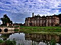
Dohna-Schlobitten Castle (2009)

Schlodien Castle (2010)

Carhaben Castle (1860)


traffic
In the station in the village of Słobity, the Schlobitten – Bischdorf (Ostpr) railway , which has not been in operation since 1945, branches off from the Malbork – Braniewo railway , the former Royal Prussian Eastern Railway . The village of Jankówko had a train station on the route to Bischdorf via Wormditt .
Individual evidence
- ↑ population. Size and Structure by Territorial Division. As of June 30, 2019. Główny Urząd Statystyczny (GUS) (PDF files; 0.99 MiB), accessed December 24, 2019 .
- ↑ The Historical Place Directory