
Wildalmkirchl
| Wildalmkirchl | ||
|---|---|---|
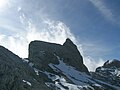
 The Wildalmkirchl with its striking shape in the form of a church. The Wildalmkirchl bivouac box is marked with a red arrow below (2457 m) |
||
| height | 2578 m above sea level A. | |
| location | Salzburg , Austria | |
| Mountains | Steinernes Meer , Berchtesgaden Alps | |
| Dominance | 0.8 km → Brandhorn | |
| Notch height | 114 m ↓ Mittagsscharte | |
| Coordinates | 47 ° 26 '51 " N , 12 ° 59' 33" E | |
|
||
| rock | Dachstein Limestone | |
| Age of the rock | Norium - Rhaetium | |
| First ascent | Richard von Frey, Max von Frey , Richard Lonsky on September 11, 1875 | |
| Normal way | Kirchdachgrat ( II ) | |

The Wildalmkirchl (formerly Wildalmkirche ) is 2578 m above sea level. A. high rocky peaks on the southern edge of the Stone Sea . It is located in the Salzburg region , northeast of the village of Maria Alm and northwest of the Hochkönigstock .
The first part of the name goes back to the Wildalm, a secluded high valley that is located north of the Wildalmkirchl in the Bavarian-Austrian border area in the Steinerne Meer; the second part of the name results from the shape of the mountain, which from different points of view resembles a church with a roof and a tower. In 2457 m altitude, north-east of the summit, the is Wildalmkirchl-bivouac (open, sleeps 8 people).
The Wildalmkirchl is next to the Schottmalhorn the most difficult summit of the Steinerne Meer to climb; all climbs require climbing. The easiest route leads from the bivouac box to the north-east approach of the church roof and up on it (brittle, I ); then you cross the Kirchdachgrat in an exposed position and climb the final summit structure with a very exposed, moderately difficult climb ( II ); a total of about 40 minutes from the bivouac box.
Approaches
- from Maria Alm ( 802 m ) or Hinterthal ( 1016 m ) via path 426 over the waterfall gap ( 2421 m ) in 5–6 hours (high alpine, easy climbing required, difficult old snow fields until late in the year).
- from the plateau of the Steinernes Meer over path 401 (from the Riemannhaus or Kärlinger Haus over the Hochbrunnsulzen pass, 2356 m ).
- From the Wasseralm over the Wildalm and before the Hochbrunnsulzen climb, cross south to the 401.
- from the south-east via path 401 (coming from the Hochkönigstock or ascending from Hinterthal via the gatarte, 2246 m ).
photos
Wildalmkirchl from the northeast
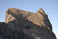
Wildalmkirchl in the morning from Biwakschachtel


cards
- Alpine Club map 1: 25,000, sheets 10/1 "Steinernes Meer" and 10/2 "Hochkönig and Hagengebirge"
Web links
- Information and a photo of the Wildalmkirchl bivouac box
- Photo with a view from the north into the Stone Sea; in the back left the Wildalmkirchl with its striking, church-like shape
Individual evidence
- ↑ Richard von Frey: The Wildalm Church on the Stone Sea. In: Journal of the German and Austrian Alpine Club , year 1877, Volume 8, pp. 69–74 ( digitized version ).