Wingecarribee River
| Wingecarribee River | ||
|
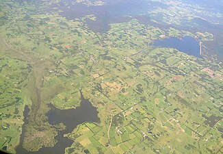
Wingecarribee Swamp (brown area left) and Fitzroy Falls Reservoir (right) |
||
| Data | ||
| location | New South Wales , Australia | |
| River system | Hawkesbury River | |
| Drain over | Wollondilly River → Coxs River → Warragamba River → Nepean River → Hawkesbury River → Tasman Sea | |
| source | at Robertson in the Great Dividing Range 34 ° 32 ′ 22 ″ S , 150 ° 29 ′ 4 ″ E |
|
| Source height | 674 m | |
| muzzle |
Wollondilly River at Tugalong coordinates: 34 ° 22 '37 " S , 150 ° 7' 24" O 34 ° 22 '37 " S , 150 ° 7' 24" O |
|
| Mouth height | 280 m | |
| Height difference | 394 m | |
| Bottom slope | 5.4 ‰ | |
| length | 73.1 km | |
| Right tributaries | Joadja Creek, Deep Creek | |
| Reservoirs flowed through | Wingecarribee Reservoir | |
| Small towns | Berrima | |
| Moor: Wingecarribee Swamp | ||
The Wingecarribee River is a river in the southeast of the Australian state of New South Wales .
course
It rises near Robertson , a small town southwest of Wollongong . The city lies between Macquarie Pass National Park and Budderoo National Park and is the home of the title character in the film A Piglet Called Babe .
From its source, the river flows northwest through the southern highlands of New South Wales, away from the sea. In Berrima it enters a narrow gorge and flows into the Wollondilly River near Tugalong .
The well-known Camp Biloela is located on the plateau that the river cuts through .
In its upper reaches the river forms the Wingecarribee Swamp , the only moor of note in New South Wales. Most of this bog has been drained, but the remaining part serves as a habitat for a number of threatened species.
As part of the Shoalhaven System , water is pumped from the Shoalhaven River into Wingecarribee Reservoir , a reservoir at the source of the Wingecarribee River, and contributes to Sydney's water supply.
Flowing lakes
- Wingecarribee Reservoir - 688 meters above sea level M.
