Wodarg (Werder)
|
Wodarg
Werder municipality
Coordinates: 53 ° 44 ′ 35 ″ N , 13 ° 20 ′ 49 ″ E
|
|
|---|---|
| Height : | 40 m above sea level NHN |
| Area : | 9.45 km² |
| Incorporation : | July 1, 1950 |
| Postal code : | 17089 |
| Area code : | 03969 |
|
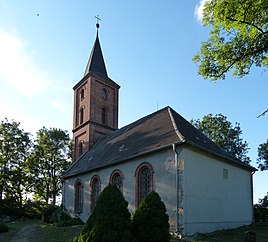
Wodarg village church
|
|
Wodarg is a district of the Werder municipality in the Mecklenburg Lake District in Mecklenburg-Western Pomerania . The place belongs to the Treptower Tollensewinkel office .
location
Wodarg is located around nine kilometers northeast of Altentreptow in the Tollensetal . Surrounding villages are Kölln in the north, Siedenbollentin in the southeast, Werder in the south, Kessin in the southwest and Weltzin in the northwest.
Wodarg is on the 65 district road and around three kilometers north of the 273 state road. Immediately to the west, the federal motorway 20 passes Wodarg, and the Altentreptow junction is around five kilometers from the town. The national highway 199 and the junction Anklam There are seven kilometers north of Wodarg.
history
In 2003 the remains of a Slavic market settlement were found during excavations in the course of the construction of the Federal Motorway 20 not far from Wodarg. This settlement probably originated in the 9th century on an important trade route between Hamburg and Stettin . This settlement is probably the present-day Conerow desert , first mentioned in a document in 1248 , which was about 2.4 kilometers northwest of Wodarg and of which there are still ruins of a castle.
When today's Wodarg was founded has not yet been fully clarified. The manor house was built in Wodarg in 1733. The Wodarg estate was owned by the von Walsleben family until 1762 when it was sold to Peter Ernst Meyenn . Via von Preen , the Wodarg estate came into the possession of Baron Helmuth von Maltzahn-VALZ in 1877 . The manor house in Wodarg received a side extension in 1919 according to plans by Wilhelm von Tettau . It is originally a single-storey, seven-axis plastered building; An English landscape park also belongs to the estate .
From 1895 until the line was closed in the 1940s, Wodarg had a stop on the Demmin – Altentreptow Landesbahn line . The von Maltzahn family managed the 900-hectare Wodarg estate until 1945, which was eventually expropriated as part of the land reform in the Soviet occupation zone. The last owner, Gerhard von Maltzahn, has since been considered missing, he was probably shot by the Soviet army. After the Second World War, refugees from eastern Germany were housed in the manor house; later it was used as a restaurant and consumption .
On July 1, 1950, Wodarg was incorporated into Werder. On July 25, 1952, the village to come circle Altentreptow (DDR Neubrandenburg ), who after reunification in district Altentreptow renamed and on 12 June 1994 with the counties Pomerania and Malchin to district Demmin was merged. Since the Demmin district was dissolved on September 4, 2011, Wodarg has been part of the Mecklenburg Lake District .
Village church
The village church of Wodarg is a plastered brick building from the 19th century. On the east gable of the church there is a relief of the coat of arms of the von Walsleben family. The altar of the church dates from the 18th century, the bell was cast by Gottlieb Becker in Stettin in 1801 . Wodarg belongs to the parish of Siedenbollentin, the church used to be a branch church of Werder.
Personalities
- Günther von Maltzahn (1910–1953), fighter pilot in World War II, was born in Wodarg
Individual evidence
- ↑ Geoportal. District of Mecklenburgische Seenplatte - Lower Surveying and Geoinformation Authority, accessed on December 1, 2019 .
- ↑ Conerow near Wodarg. In: slawenburgen.hpage.com , accessed on November 24, 2019.
- ^ Gutshof Wodarg / Werder municipality near Altentreptow. In: heimat-mecklenburgische-seenplatte.de , accessed on November 24, 2019.
- ^ Heinrich Berghaus : Land book of the Duchy of Pomerania and the Principality of Rügen. First volume, W. Dietze, Anklam 1865, p. 141 ( online )

