Woodanilling
| Woodanilling | |||||||
|---|---|---|---|---|---|---|---|
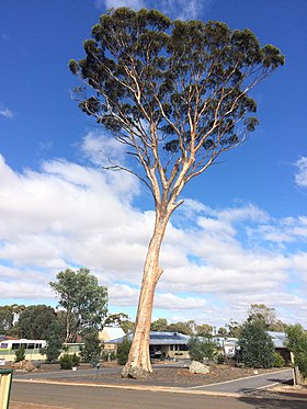
 Eucalyptus tree in woodanilling |
|||||||
|
|||||||
|
|||||||
|
|||||||
|
|||||||
|
|
|||||||
Woodanilling is a location in the Great Southern Region of Western Australia . It is located in a sheep-raising area and a grain-growing region .
etymology
The place was named after the source of Boyerine Creek. The word woodanilling comes from the Aboriginal language and means a lot of minnows or the place where the white-forehead pigeon nests .
geography
Woodanilling is 254 kilometers south of Perth on the Great Southern Highway , 15 miles from Katanning and 30 miles from Wagin . After the census in 2016 here 170 people lived.
history
The area was first explored by Europeans between 1830 and 1831 . The captain Thomas Bannister was the leader of the expeditions.
The expansion of the Albany Highway in the early 1850s and the Great Southern Railway in 1889 brought residents to the area and were very important in establishing the site, which was announced in 1892.
Web links
Individual evidence
- ↑ Australian Bureau of Statistics : Woodanilling (State Suburb) ( English ) In: 2016 Census QuickStats . June 27, 2017. Retrieved April 7, 2020.
