Wuppertalsperre
| Wuppertalsperre | |||||||
|---|---|---|---|---|---|---|---|
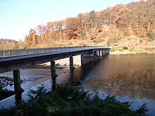
| The Wuppertalsperre near Radevormwald- Honsberg | |||||||
|
|||||||
|
|
|||||||
| Coordinates | 51 ° 11 ′ 54 " N , 7 ° 18 ′ 4" E | ||||||
| Data on the structure | |||||||
| Construction time: | 1982-1987 | ||||||
| Height above valley floor: | 35 m | ||||||
| Height above foundation level : | 41 m | ||||||
| Height above the river bed : | 39 m | ||||||
| Height of the structure crown: | 255.00 m | ||||||
| Building volume: | 500,000 m³ | ||||||
| Crown length: | 320 m | ||||||
| Crown width: | 10.5 m | ||||||
| Power plant output: | 2.4 MW | ||||||
| Data on the reservoir | |||||||
| Altitude (at congestion destination ) | 252.50 m | ||||||
| Water surface | 225 ha | ||||||
| Storage space | 25.9 million m³ | ||||||
| Catchment area | 212 km² | ||||||
| Design flood : | 318 m³ / s | ||||||
| Dam of the Wuppertalsperre near Radevormwald- Krebsöge | |||||||
The Wuppertalsperre lies in the city triangle Remscheid , Radevormwald and Hückeswagen . It is a process water dam . It serves to increase the low water level, protect the Wupper from flooding and generate hydropower .
History and general facts
The basic planning work was completed in 1957. In 1962, the preparatory work began, such as the laying of roads and a drinking water pipe. The construction of the main dam took place from 1982 to 1987. The start-up and completion of the dam took place in 1989. The barrier structure, the 320 m long and 40 m high dam of the dam, consists of a stone fill with an asphalt concrete inner seal . The maximum storage volume of the dam is 25.9 million m³ with an annual inflow of around 138 million m³. 440 hectares of land were purchased for the dam. At the time, the total cost of the dam was 235 million marks.
There are a total of five pre -dams of the Wupper Dam:
- Wupper pre-lock
- Wiebach pre-lock
- Dörpe lock
- Feldbach pre-lock
- Lenneper Bach pre-lock
Other tributaries into the Wuppertalsperre are:
Sunken towns, industrial plants and sights
The Wupperbrücke in Kräwinklerbrücke is the oldest surviving - but sunken - bridge over the Wupper. It was built "a few decades" before the Wupper Bridge, which was completed in 1775, in Barmen-Heckinghausen.
Before the dam was built in 1982–1987, the following localities and facilities were demolished and finally flooded by the dammed water:
- Carolinengrube
- Cöens Mill
- Dörpe (with Jung-Stilling House)
- Enneper steelworks in Dörpe
- Hammersteinsöge
- Old felt factory
- Hof Hammerstein (old noble residence, not to be confused with Haus Hammerstein, which is the only building left today)
- Maria zur Mühlen chapel (Kräwinklerbrücke)
- Kräwinklerbrücke (large parts of the village)
- Krebsöge (parts of the village, was a railway junction)
- Urbach & Co. steelworks (Kräwinklerbrücke)
- Nieder- and Oberkretze
- Hummeltenberger mill
- Löbbeckes Mill
- Oege
- Wiebachtal (see also Wiebach and Wiebach pre-lock )
- Himmelswiese (excursion destination)
- Hut der Naturfreunde, later SGV-Heim
- Moonstone (step stones that were the basis of a Bergisch legend)
As part of the construction of the dam, the Wuppertal - Radevormwald - Bruges railway ( Wuppertal Railway , route number 2704) between Wilhelmstal and Radevormwald was shut down in 1980 . The Krebsöge train station (Remscheid-Lennep - Krebsöge and Wuppertal - Bruges routes) was located at the site of the dam. The Kräwinklerbrücke station was demolished, as was the entire railway system in the congestion area.
leisure

The Wuppertalsperre with its possibilities for recreational activities is a magnet for visitors from the entire region. Leisure activities include numerous hiking and biking trails, rest areas, holiday homes and a marina for sailing and rowing boats.
The medieval ring wall system Am Bilstein is located at the Wuppertalsperre . The ground monument can be reached via a junction from the A 7 hiking trail.
Diving

The dam is not a safe area for amateur divers ; The frogmen tell each other horror stories about some ditches under water. Nevertheless - or maybe because of this - the Wuppertalsperre between Radevormwald , Remscheid and Hückeswagen has become a Dorado for scuba divers .
For 15 years, from 1995 to 2010, the rights for water sports use of the Wuppertalsperre were in the hands of the water sports and leisure facility Kräwinklerbrücke GmbH . In 2010, after a long legal dispute with the company and the city of Remscheid, the rights were transferred to GABE gGmbH ; a non-profit company that has set itself the task of employing, qualifying and training young people and the (long-term) unemployed in order to improve their chances on the job market.
Sights (underwater):
- fully preserved viaduct with three submersible bridge arches
- Wooden weir
- buried bridge arch
- Quarry stone wall edging the bridge
- Factory facade
- Rock walls
literature
- Norbert Wolff: Sunk in the Wupper floods . Geiger, Horb am Neckar 1999, ISBN 3-89570-610-8 .
- Manfred Heymann: "Crab-roe original". The small town before the Wupper Dam was built. A nostalgia. Jungdruck, Radevormwald 2007.
- Heinz-Dieter Dörner: History from the Wupper dam. Illustrated book with chronicles and descriptions of the Kräwinkler Bridge and the Krebsöge. WFT Verlag. Wermelskirchen 2005, ISBN 3-929095-21-1 .
Individual evidence
- ^ Karl-Heinz Marpe in a letter to the editor to the Bergische Morgenpost on March 14, 1987
See also
Web links
- The website of the Wupper Association
- A private homepage about the Wuppertalsperre ( Memento from January 9, 2014 in the Internet Archive )
- Dams directory NRW (PDF; 122 kB)


