Yellowknife Highway
| Highway 3 in the Northwest Territories, Canada | ||||||||||||||||||||||
| Yellowknife Highway | ||||||||||||||||||||||

|
||||||||||||||||||||||
| Basic data | ||||||||||||||||||||||
| Operator: | Northwest Territories Department of Transportation |
|||||||||||||||||||||
| Start of the street: |
Yellowknife ( 62 ° 28 ′ N , 114 ° 23 ′ W ) |
|||||||||||||||||||||
| End of street: |
Fort Providence ( 61 ° 4 ′ N , 117 ° 30 ′ W ) |
|||||||||||||||||||||
| Overall length: | 340 km | |||||||||||||||||||||
|
Region : |
||||||||||||||||||||||
| Bridge over the Frank Channel near Behchokò | ||||||||||||||||||||||
|
Course of the road
|
||||||||||||||||||||||
The Highway 3 , better known by the name of Yellowknife Highway or Great Slave Highway , connecting the capital of the Northwest Territories , Yellowknife , with the Mackenzie Highway (Highway 1) . The highway ends 188 km north of the Alberta border . The road was built in 1960 and has been paved throughout since 2006 .

The highway also connects Behchokò and Fort Providence to civilization. From Yellowknife, the Ingraham Trail (Highway 4) leads around 70 km north to connect the ice roads used in winter to the road system.
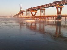
The Mackenzie River (south of Fort Providence) was crossed from 1960 to November 2012 by means of a ferry service (May – January) and an ice bridge (December – March). The road had to be closed for around five weeks each spring due to the breaking ice.
On November 30, 2012, the Deh-Cho Bridge over the river was ceremoniously opened to replace the ferry service and the ice bridge. Trucks traveling northwards have to pay a fee to use the bridge. It is possible to register your truck in advance, for which the fee will be charged. Private vehicles can cross the bridge for free.


