Yzeron (river)
| Yzeron | ||
|
The river in the urban area of Oullins |
||
| Data | ||
| Water code | FR : V3010500 | |
| location | France , Auvergne-Rhône-Alpes region | |
| River system | Rhône | |
| Drain over | Rhône → Mediterranean | |
| source | on the municipal boundary of Montromant and Yzeron 45 ° 42 ′ 50 ″ N , 4 ° 34 ′ 33 ″ E |
|
| Source height | approx. 725 m | |
| muzzle | on the municipal boundary of Oullins and La Moulatière in the Rhône Coordinates: 45 ° 43 ′ 8 ″ N , 4 ° 49 ′ 9 ″ E 45 ° 43 ′ 8 ″ N , 4 ° 49 ′ 9 ″ E |
|
| Mouth height | approx. 160 m | |
| Height difference | approx. 565 m | |
| Bottom slope | approx. 23 ‰ | |
| length | 25 km | |
| Medium-sized cities | Oullins | |
| Small towns | Craponne , Francheville , La Moulatière | |
|
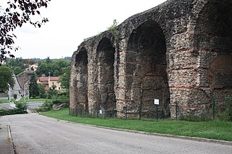
The Aqueduc du Gier crosses the Yzeron valley |
||
The Yzeron is a river in France that runs in the Rhône department in the Auvergne-Rhône-Alpes region . It rises on the municipal boundary of Montromant and Yzeron , generally drains in an easterly direction through a densely populated area and flows into the Rhône as a right tributary after 25 kilometers in the greater area south of Lyon , on the municipal boundary of Oullins and La Moulatière .
Places on the river
history
The water of the Yzeron was already used to supply the city of Lyon in ancient times . In the 1st century AD, for example, an aqueduct was built from Yzeron to Lugdunum , as Lyon was called at that time. The aqueduct ran a little further north than the current river and crossed the villages of Vaugneray and Craponne , where the remains of this structure can still be seen today. They were placed under protection as a monument historique .
The Aqueduc du Gier also crosses the Yzeron valley near Beaunant from the southwest.
See also
Web links
- Roman aqueducts in Lyon (French)
- Aqueduc du greed. In: Structurae
Individual evidence
- ↑ Source height according to geoportail.gouv.fr
- ↑ mouth height according to geoportail.gouv.fr
- ↑ a b The information on the length of the river is based on the information about the Yzeron at SANDRE (French), accessed on May 10, 2012, rounded to full kilometers.
- ↑ Aqueduc de l'Yzeron in the Base Mérimée of the French Ministry of Culture (French)

