
Zurichhorn


The Zürichhorn is an alluvial cone on the east bank of the lower lake basin of Lake Zürich . It is part of the park and quay facilities in Zurich's Seefeld district . The green spaces are a popular local recreation area in the city of Zurich.
geography
The Zürichhorn was essentially formed by the Hornbach , which is called Wildbach and Werenbach on its upper reaches . The course of the river, which is integrated into a concrete canal, flows into Lake Zurich at the park between the Tiefenbrunnen outdoor pool and the Zürichhorn.
Since the withdrawal of the Linth glacier after the Würm the Werenbach has over the past 10,000 to 15,000 years its present bed through the moraine dug. In some places it hit the rocky subsoil, the molasses . The debris created an alluvial cone on Lake Zurich, which developed into a small delta and is still clearly visible today at the Zurichhorn.
history
In 1238 today's Hornbach is mentioned as «Otinbach», which can be derived from «Bach des Otto», from the Old High German «ôt» for «genetic material, rich inheritance». The former field name Oetenbach could refer to the course of the river, on the banks of which Otto owned an estate or to which he owned fishing or other rights. The first Oetenbach monastery was built on the Zürichhorn around the same time ; Due to a lack of experience, however, the sisters built on swampy ground and too close to the water, so that the " nuns saw that ir closter was almost standing by the water, so they were heartily saddened, that they were crying bitterly ". Around 1280/85 the Dominicans moved the convent to the Sihlbühl near the Lindenhof .

After in the course of the 16./17. Century rich townspeople had built their country estates near the shore of today's Seefeld, in the 1840s various stone carving businesses settled on the Zürichhorn . The raw material was delivered by water, the land-side development of the site took place via Fröhlichstrasse. By the end of the 19th century, what was then "Hornegg" developed into a center for ancillary construction businesses, and its location on the lake also attracted shipyards. With the construction of the Tiefenbrunnen port and the opening of the Zurichseebahn on the right bank , the center of the workshops moved to what was then the city limits.
In the years 1879 to 1881, the course of the torrent was corrected in order to contain the recurring floods in what was then Riesbach . The brook was diverted south into Lake Zurich and was henceforth called Hornbach in the lower part. After the opening of the quay in 1887, the park was expanded from the Seefeldquai to the Zürichhorn in order to promote “ sociability, relaxation and entertainment ”. The landscape architects Otto Froebel and Evariste Mertens designed a spacious park landscape, including the existing trees.
Zurichhorn water airport

As early as the summer of 1910, the "Wagenfabrik C. & R. Geissberger" carried out initial tests with hydro tarpaulins (flying boats) in front of their assembly hall on the Zürichhorn . Under the direction of Oskar Bider and Fritz Rihner , the "Swiss Society for Air Tourism" was founded in July 1919, with its headquarters in Zurich. Tourist flights with flying boats were planned from stations on the Zürichhorn, in Geneva, Interlaken / Thun, Locarno, Lugano, Lucerne, Ouchy, Romanshorn and St. Moritz. Switzerland with its numerous lakes appeared to Bider to be predestined for the use of seaplanes, so that the construction of expensive airfields could be dispensed with. Oskar Bider had a fatal accident before his project was realized, but from 1919 seaplanes of the Swiss airline Ad Astra Aero were deployed from the Zürichhorn and today's Tiefenbrunnen resort . The machines used included seven Macchi -Nieuport and five Savoia flying boats, as well as the first large flying boat, the Dornier Wal , which aroused great astonishment among the Zurich public .
Attractions
Sights are the spacious parks and quays with various sculptures such as Jean Tinguely's Heureka , the Zurich Chinese Garden on Blatterwiese and to the northwest of it the last building designed by the architect Le Corbusier , today's Heidi Weber Museum and Center Le Corbusier . The Tiefenbrunnen resort is located on the southern side of the delta. The Fischstube restaurant was built for the 1939 national exhibition , the only house in the city of Zurich with a thatched roof. In 1956 the main building was destroyed by arson and rebuilt. A new building is to be built due to dilapidation.

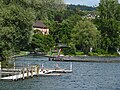
The pier on the Zürichhorn in February 2014

The Chinese garden on the Blatterwiese

The Fischstube restaurant with its distinctive thatched roof
Lido Tiefenbrunnen


_-_Z%C3%BCrich-Landid%C3%B6rfli_(Z%C3%BCrichhorn)_1939.jpg)
Among the numerous major events on the Zürichhorn are the Swiss National Exhibition in 1939 , the Swiss Horticultural Exhibition G59 and in 1984 the scientific exhibition Phenomena . The Kino am See, now known as Allianz Cinema , has been taking place between mid-July and mid-August since 1987 . The lake facilities in the area of the Zürichhorn and the Blatterwiese are visited by around 2.5 million people looking for relaxation every year.
Web links
Individual evidence
- ↑ Website Cicerone Performance: Oetenbachgasse in the minor city ( memento of July 6, 2011 in the Internet Archive ), accessed on January 30, 2010
- ↑ a b Website Gang dur Alt-Zürich: The Zürichhorn and civil aviation , accessed on January 30, 2010
- ↑ a b Website Stadt Zürich, Grün Stadt Zürich: Zürichhorn , accessed on November 21, 2013
- ^ Website of the Fischstube restaurant , accessed on January 30, 2010
- ↑ Jürg Rohrer: Zurich's slowest fisherman. In: Restaurant Fischerstube. Tages-Anzeiger, January 9, 2016, accessed January 19, 2016 .
Coordinates: 47 ° 21 '13 " N , 8 ° 33' 7.6" E ; CH1903: 684 127 / two hundred forty-five thousand three hundred and forty-eight