Zellergraben (Main)
| Zellergraben | ||
|
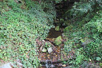
The Zellergraben shortly before it flows into the Main |
||
| Data | ||
| Water code | DE : 245394 | |
| location | Germany | |
| River system | Rhine | |
| Drain over | Main → Rhine → North Sea | |
| source | on the Franconian plate south of Steinfeld - Waldzell 49 ° 56 ′ 22 ″ N , 9 ° 37 ′ 47 ″ E |
|
| Source height | approx. 297 m above sea level NHN | |
| muzzle | south of Lohr am Main - Pflochsbach in the Main coordinates: 49 ° 57 '3 " N , 9 ° 35' 58" E 49 ° 57 '3 " N , 9 ° 35' 58" E |
|
| Mouth height | 150 m above sea level NHN | |
| Height difference | approx. 147 m | |
| Bottom slope | approx. 45 ‰ | |
| length | 3.3 km | |
| Catchment area | 6.24 km² | |
The Zellergraben , also known as the Zeller Graben , is a three-kilometer long stream on the edge of the Spessart Nature Park in the Lower Franconian district of Main-Spessart , which flows into the Main from the left when coming from the south-east .
geography
course
The Zellergraben is created on the Franconian Platte near Steinfeld - Waldzell from several source streams. The longest and intermittent source branch rises at a height of about 297 m above sea level. NN in the Feldflur Oberer Krautgarten, south of Waldzell, west of the local main road. It initially flows about a hundred meters in a northerly direction and is reinforced shortly before it reaches the southwestern outskirts of Waldzell by a source branch coming from the southeast. The Zellergraben now flows in a north-westerly direction through the southeastern tip of Waldzell and then runs along the western edge of the village to Gertraudenweg . There it bends at a right angle to the northeast, then runs south of the Gertraudenweg about a hundred meters through the village and then also turns again at a right angle to the northwest. There it is fed by a second source branch on its right side. The Zellgraben now crosses the Gertraudenweg and leaves Waldzell after about one hundred and sixty meters. Sixty meters down the stream it crosses Lohrer Strasse and is then strengthened a little later by another spring branch. Shortly afterwards, a spring brook that is water-bearing all year round for the first time also flows from the right. The stream then crosses Lohrer Straße again and then flows south of the MSP 22 district road westwards through the Untere Wiesen corridor . At a sewage treatment plant , it leaves the open corridor and now flows through deciduous forest. After about four hundred meters, its most important tributary, the Gertraudengraben coming from the south, reaches it on its left . Accompanied by the MSP 22, the Zellergraben now flows west of the Untere Sommerleiten corridor and east of the Winterleiten corridor in a north-westerly direction through a very narrow, wooded valley, then passes the district boundary from Steinfeld to Lohr am Main , then crosses under the MSP 23 and finally joins one Height of about 150 m above sea level. NN south of Lohr am Main- Pflochsbach in the Flur Am zeller Graben from the left into the Main coming from the north .
Tributaries
- Gertraudengraben ( left )
See also
Individual evidence
- ↑ a b BayernAtlas of the Bavarian State Government ( notes )
- ↑ a b Directory of stream and river areas in Bavaria - Main river area, page 121 of the Bavarian State Office for the Environment, as of 2016 (PDF; 3.3 MB)
Web links
- The Zellergraben on the BayernAtlas
- Map of the catchment area in the basic data for flowing waters of Bavaria, Bavarian State Office for the Environment
