
Unterrothorn
| Unterrothorn | ||
|---|---|---|
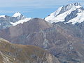
 Unterrothorn with (from left to right in the background) Matterhorn , Dent Blanche , Ober Gabelhorn and Wellenkuppe . Taken on the ascent to the Oberrothorn |
||
| height | 3104 m above sea level M. | |
| location | District of Visp , Canton of Valais , Switzerland | |
| Mountains | Valais Alps | |
| Dominance | 1.05 km → Oberrothorn | |
| Notch height | 123 m ↓ Furggji | |
| Coordinates | 627 796 / 96776 | |
|
||

The Unterrothorn is 3104 m above sea level. M. high mountain in the canton of Valais , near Zermatt . The Unterrothorn is located around 5 km east of the village and marks the highest point of the Zermatt-Rothorn ski area , which can be reached from Sunnegga and Blauherd by metro, gondola and cable car or from the Kumme with a chair lift .
At the summit there is a small restaurant, the mountain station and a small weather station . The Rothorn attracts tourists in both summer and winter . The Rothorn offers a beautiful view of the Matterhorn and the mountain is the beginning of many descents to Zermatt, on the other hand high alpine tours to the Rimpfischhorn , the Strahlhorn or to Cima di Jazzi also start there . Another hike leads to the Oberrothorn ( 3414 m above sea level ). In addition to the Matterhorn, the Rothorn panorama includes the Dent Blanche , the Monte Rosa massif , the Weisshorn and the Mischabel .
photos

Summit with Zinalrothorn and on the far right Weisshorn

View from Oberrothorn: Unterrothorn in front and Matterhorn and Zmutt valley in the background
Unterrothorn with Allalinhorn , Oberrothorn, Rimpfischhorn, Blauherd and Sunnegga

