Zna (Mstino Lake)
|
Zna Цна |
||
| Data | ||
| Water code | RU : 01040200112102000019785 | |
| location | Tver Oblast ( Russia ) | |
| River system | Neva | |
| Drain over | Msta → Volkhov → Neva → Baltic Sea | |
| source | on the Waldai heights 57 ° 11 ′ 50 ″ N , 33 ° 57 ′ 0 ″ E |
|
| muzzle | in the Mstino lake coordinates: 57 ° 37 ′ 41 ″ N , 34 ° 31 ′ 25 ″ E 57 ° 37 ′ 41 ″ N , 34 ° 31 ′ 25 ″ E |
|
| Mouth height |
154 m
|
|
| length | 160 km | |
| Catchment area | 4420 km² (according to other sources 4140 km²) | |
| Outflow location: 38 km above the mouth |
MQ |
12.3 m³ / s |
| Left tributaries | Schlina | |
| Reservoirs flowed through | Vysnevolotskoye | |
| Medium-sized cities | Vyshny Volochok | |
|
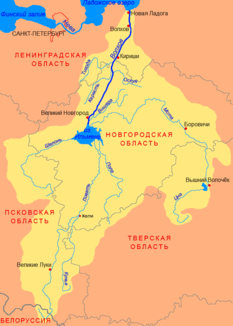
Location of the Zna (Цна) in the catchment area of the Volkhov |
||
The Zna ( Russian Цна ) is a 160 km long river in the river system of the Neva River in Russia's Tver Oblast .
It rises on the Valdai Heights near the watershed between the Neva and the Volga . From there it flows mainly in a northerly direction. The river is close to the city vyshny volochyok to 109 km² Wyschnewolozkoje dammed -Stausee. Then the Zna Wyschni Volotschok flows through and flows into the Mstino Lake . This is drained from the Msta to the Ilmensee . However, a large part of the water is diverted from the Vysnevolotskoye reservoir via a canal to the Tverza , a tributary of the Volga.
The catchment area of the Zna covers approx. 4420 km². The mean discharge 38 km before the mouth is 12.3 m³ / s.
Due to its location, an important trade route used to run along the river.

