Širákov: Difference between revisions
Content deleted Content added
Dr. Blofeld (talk | contribs) No edit summary |
m unapproved bot, blanking sections |
||
| (18 intermediate revisions by 14 users not shown) | |||
| Line 1: | Line 1: | ||
{{unreferenced|date=May 2010}} |
|||
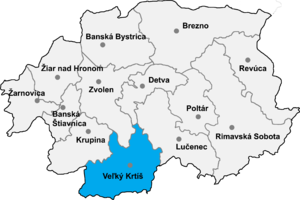
[[Image:Okres velky.png|thumb|right|300px|[[Veľký Krtíš District]] in the |
[[Image:Okres velky.png|thumb|right|300px|[[Veľký Krtíš District]] in the Banská Bystrica region]] |
||
'''Širákov''' is a [[village]] and [[municipality]] in the [[Veľký Krtíš District]] of the [[Banská Bystrica Region]] of southern [[Slovakia]]. |
'''Širákov''' ({{lang-hu|Sirak}}) is a [[village]] and [[municipality]] in the [[Veľký Krtíš District]] of the [[Banská Bystrica Region]] of southern [[Slovakia]]. |
||
[[Image:Slovakiakrajenumbers.png|left|thumb|300px|6: Banská Bystrica Region]] |
|||
==External links== |
|||
*[http://www.statistics.sk/mosmis/eng/run.html Statistics] |
|||
{{Velky Krtis District}} |
{{Velky Krtis District}} |
||
| ⚫ | |||
{{coord|48|09|N|19|11|E|region:SK_type:city|display=title}} |
|||
[[Category:Villages and municipalities in the Banská Bystrica Region|Sirakov]] |
|||
| ⚫ | |||
{{authority control}} |
|||
{{DEFAULTSORT:Sirakov}} |
|||
| ⚫ | |||
| ⚫ | |||
Latest revision as of 10:22, 29 September 2022

Širákov (Hungarian: Sirak) is a village and municipality in the Veľký Krtíš District of the Banská Bystrica Region of southern Slovakia.
External links[edit]
48°09′N 19°11′E / 48.150°N 19.183°E
