Glabušovce: Difference between revisions
Content deleted Content added
m unapproved bot, blanking sections without removing headers |
m #article-add-desc Tags: Mobile edit Mobile app edit iOS app edit |
||
| Line 1: | Line 1: | ||
{{Short description|Village and municipality in Slovakia}} |
|||
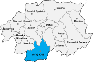
[[Image:Okres velky.png|thumb|right|300px|Veľký Krtíš District in the Banská Bystrica region]] |
[[Image:Okres velky.png|thumb|right|300px|Veľký Krtíš District in the Banská Bystrica region]] |
||
'''Glabušovce''' ({{lang-hu|Galábocs}}) is a [[village]] and [[municipality]] in southern [[Slovakia]]. It is located in the [[Veľký Krtíš District]] of the [[Banská Bystrica Region]]. |
'''Glabušovce''' ({{lang-hu|Galábocs}}) is a [[village]] and [[municipality]] in southern [[Slovakia]]. It is located in the [[Veľký Krtíš District]] of the [[Banská Bystrica Region]]. |
||
Latest revision as of 12:57, 5 March 2024

Glabušovce (Hungarian: Galábocs) is a village and municipality in southern Slovakia. It is located in the Veľký Krtíš District of the Banská Bystrica Region.
History[edit]
In historical records, the village was first mentioned in 1297. Then known as Galabuch, it belonged to many feudatories, including Kacsics, Prónyai and Beney. In 1554, Glabušovce was completely destroyed by the Ottoman Turks, who dominated the area from 1554 to 1594. From 1938 to 1945, it was controlled by Hungary.
Genealogical resources[edit]
The records for genealogical research are available at the state archive "Statny Archiv in Banska Bystrica, Slovakia"
- Roman Catholic church records (births/marriages/deaths): 1787-1874 (parish B)
- Lutheran church records (births/marriages/deaths): 1745-1931 (parish B)
See also[edit]
External links[edit]
- https://web.archive.org/web/20080111223415/http://www.statistics.sk/mosmis/eng/run.html
- http://www.e-obce.sk/obec/glabusovce/glabusovce.html
- Surnames of living people in Glabusovce
48°09′N 19°28′E / 48.150°N 19.467°E
