
Mars Polar Lander: Difference between revisions
copied material from http://nssdc.gsfc.nasa.gov/database/MasterCatalog?sc=1999-001A |
→Launch and trajectory: cleaning up/removing nonexistent parameters across Wikipedia using AutoWikiBrowser, typo(s) fixed: 7425-9 → 7425–9 |
||
| (442 intermediate revisions by more than 100 users not shown) | |||
| Line 1: | Line 1: | ||
{{short description|Failed 1999 robotic Mars lander}} |
|||
The '''Mars Polar Lander''' was part of the [[Mars Surveyor '98 program]], which consisted of two spacecraft launched separately, the [[Mars Climate Orbiter]] (formerly the Mars Surveyor '98 Orbiter) and the Mars Polar Lander (formerly the Mars Surveyor '98 Lander). The two missions were designed to study the [[Mars (planet)|Martian]] [[weather]], [[climate]], and [[water]] and [[carbon dioxide]] budget, in order to understand the reservoirs, behavior, and [[celestial body atmosphere|atmospheric]] role of volatiles and to search for evidence of long-term and episodic climate changes. |
|||
{{Use mdy dates|date=May 2020|cs1-dates=ly}} |
|||
The last telemetry from Mars Polar Lander was sent just prior to atmospheric entry on [[December 3]] [[1999]]. No further signals have been received from the lander, the cause of this loss of communication is not known. The leading theory is that a surface contact detector located on the landing struts mistakenly interpreted the force of the landing strut's deployment as contact with the surface, causing the landing rockets to shut down prematurely and the probe to impact at too high a velocity. |
|||
{{Infobox spaceflight |
|||
| name = Mars Polar Lander |
|||
| names_list = Mars Surveyor '98<!--list of previous names if the spacecraft has been renamed. |
|||
Include the dates applicable if possible, and separate each name with a linebreak. |
|||
Omit if the spacecraft has only ever been known by one name. |
|||
Do not include Harvard, COSPAR/NSSDC or SATCAT/NORAD/NASA designations as alternative names--> |
|||
<!--image of the spacecraft/mission--> |
|||
==Scientific Objectives== |
|||
| image = [[File:Mars Polar Lander - artist depiction.png|290px|]] |
|||
| image_caption = Artist's depiction of the Mars Polar Lander on Mars |
|||
| image_alt = <!--image alt text--> |
|||
| image_size = <!--include px/em; defaults to 220px--> |
|||
<!--Basic details--> |
|||
The Mars Polar Lander was to touch down on the southern polar layered terrain, between 73°S and 76°S, less than 1000 km from the [[south pole]], near the edge of the carbon dioxide ice cap in Mars' late southern spring. The terrain appears to be composed of alternating layers of clean and dust-laden ice, and may represent a long-term record of the climate, as well as an important volatile reservoir. The mission had as its primary science objectives to: |
|||
| mission_type = [[Lander (spacecraft)|Lander]] |
|||
#record local meteorological conditions near the martian south pole, including temperature, pressure, humidity, wind, surface frost, ground ice evolution, ice fogs, haze, and suspended dust |
|||
| operator = [[NASA]] / [[JPL]] |
|||
#analyze samples of the polar deposits for volatiles, particularly water and carbon dioxide |
|||
| Harvard_designation = <!--spacecraft launched 1962 and earlier only (eg. 1957 Alpha 2)--> |
|||
#dig trenches and image the interior to look for seasonal layers and analyze soil samples for water, ice, hydrates, and other aqueously deposited minerals |
|||
| COSPAR_ID = 1999-001A |
|||
#image the regional and immediate landing site surroundings for evidence of climate changes and seasonal cycles |
|||
| SATCAT = 25605 |
|||
#obtain multi-spectral images of local regolith to determine soil types and composition. |
|||
| website = [http://mars.jpl.nasa.gov/msp98/lander/ Mars Polar Lander website] |
|||
| mission_duration = {{age in days|1999|01|03|1999|12|03}} days<br/>Mission failure |
|||
| distance_travelled = <!--How far the spacecraft travelled (if known)--> |
|||
| orbits_completed = <!--number of times the spacecraft orbited the Earth – see below for spacecraft beyond Earth orbit--> |
|||
| suborbital_range = <!--downrange distance reached if spacecraft did not enter orbit--> |
|||
| suborbital_apogee = <!--altitude reached if spacecraft did not enter orbit--> |
|||
<!--Spacecraft properties--> |
|||
These goals were to be accomplished using a number of scientific instruments, including a Mars Volatiles and Climate Surveyor (MVACS) instrument package which was comprised of a robotic arm and attached camera, mast-mounted surface stereo imager and meteorology package, and a gas analyzer. In addition, a Mars Descent Imager (MARDI) was planned to capture regional views from parachute deployment at about 8 km altitude down to the landing. The Russian Space Agency provided a laser ranger (LIDAR) package for the lander, which would be used to measure dust and haze in the Martian atmosphere. A miniature microphone was also be on board to record sounds on Mars. Attached to the lander spacecraft were a pair of small probes, the Deep Space 2 Mars Microprobes, which were to be deployed to fall and penetrate beneath the martian surface when the spacecraft reached Mars. |
|||
| spacecraft = <!--Spacecraft name/serial number (eg. Space Shuttle ''Discovery'', Apollo CM-118), etc--> |
|||
| spacecraft_type = <!--eg. GPS Block II, Kobalt-M, US-K, etc--> |
|||
| spacecraft_bus = <!--eg. A2100M, Star-2, etc--> |
|||
| manufacturer = [[Martin Marietta]] |
|||
| launch_mass = 583 kg<ref>{{cite web|url=https://nssdc.gsfc.nasa.gov/nmc/spacecraft/display.action?id=1999-001A |title=Mars Polar Lander |publisher=[[NASA Space Science Data Coordinated Archive]] |access-date=December 1, 2022}}</ref> |
|||
| BOL_mass = <!--spacecraft mass in orbit at beginning of operational life, after LEOP phase--> |
|||
| landing_mass = <!--Mass after landing (recovered spacecraft only)--> |
|||
| dry_mass = <!--spacecraft mass in orbit without fuel--> |
|||
| payload_mass = <!--Mass of cargo carried by spacecraft (eg. for Space Shuttle), or total mass of instrumentation/equipment/experiments for mission--> |
|||
| dimensions = <!--body dimensions and solar array span--> |
|||
| power = 200 W [[solar array]] and [[Nickel hydrogen battery|NiH{{small|<sub>2</sub>}} battery]] |
|||
<!--Launch details--> |
|||
==Spacecraft and Subsystems== |
|||
| launch_date = {{start date|1999|01|03|20|21|10|7=Z}} |
|||
| launch_rocket = [[Delta II]] 7425-9.5 |
|||
| launch_site = [[Cape Canaveral Air Force Station Space Launch Complex 17|Cape Canaveral AFS SLC-17A]] |
|||
| launch_contractor = <!--organisation(s) that conducted the launch (eg. United Launch Alliance, Arianespace, etc)--> |
|||
| deployment_from = <!--place where deployed from--> |
|||
| deployment_date = <!--date deployed--> |
|||
| entered_service = <!--date on which the spacecraft entered service, if it did not do so immediately after launch--> |
|||
<!-- * - e.g. Proton-M/Briz-M not Proton-M, but Titan IV(401)A not Titan IV(401)A-Centaur--> |
|||
<!--end of mission--> |
|||
The Mars Polar Lander consists of a hexagonal base composed of aluminum honeycomb with composite graphite epoxy face sheets supported on three aluminum landing legs. The lander stands 1.06 m tall and approximately 3.6 m wide. The launch mass of the spacecraft is approximately 583 kg, including 64 kg of fuel, an 82 kg cruise stage, a 140 kg aeroshell/heatshield, and the two 3.5 kg microprobes. A thermally regulated interior component deck holds temperature sensitive electronic components and batteries and the thermal control system. Two solar panels extend out from opposite sides of the base. Mounted on top of the base are the robotic arm, the stereo imager and mast, a UHF antenna, the LIDAR, the MVACS electronics, the meteorology mast and the medium gain dish antenna. The MARDI is mounted at the base of the lander, and the propellant tanks are affixed to the sides. During cruise, the lander is attached to the cruise stage and enclosed in the 2.4 meter diameter aeroshell. |
|||
| disposal_type = communication failure after landing |
|||
| deactivated = <!--when craft was decommissioned--> |
|||
| destroyed = <!--when craft was destroyed (if other than by re-entry)--> |
|||
| last_contact = {{end date|1999|12|03|20|00|7=Z}} |
|||
| declared = {{end date|2000|01|17}} |
|||
| recovery_by = <!--recovered by--> |
|||
| recovery_date = <!--recovery date--> |
|||
| decay_date = <!--when craft re-entered the atmosphere, not needed if it landed--> |
|||
| landing_date = <!--when the spacecraft made a controlled landing, not needed if it did not return intact--> |
|||
| landing_site = <!--where the craft landed; site/runway or coordinates--> |
|||
<!-- |
|||
The following template should be used for ONE of the three above fields "end_of_mission", "decay" or "landing" if the spacecraft is no longer operational. |
|||
If it landed intact, use it for the landing time, otherwise for the date it ceased operations, or the decay date if it was still operational when it re-entered. |
|||
{{end date|YYYY|MM|DD|hh|mm|ss|TZ=Z}} (for Zulu/UTC) or {{end date|YYYY|MM|DD}} (if time unknown) |
|||
--> |
|||
<!--orbit parameters--> |
|||
The spacecraft was three-axis stabilized during cruise using star cameras and sun sensors in conjunction with inertial measurement units. Four hydrazine cruise reaction engine modules, each consisting of one 5-lbf trajectory correction maneuver thruster and one canted 1-lbf reaction control system thruster, provided attitude control. The descent and landing propulsion system consists of three groups of four pulse modulated 266 N hydrazine engines. Control and knowledge for descent and landing is provided by a 4 beam doppler radar system and an AACS subsystem. The hydrazine is stored in two diaphragm tanks with a total capacity of 64 kg for both cruise and descent systems. |
|||
<!--as science-related articles, SI units should be the principal units of measurement, however we usually use {{convert}} to display imperial units in parentheses after the initial values--> |
|||
| orbit_reference = <!--geocentric, selenocentric, etc – please link (e.g. [[Geocentric orbit|Geocentric]])--> |
|||
| orbit_regime = <!--high, low, medium, molniya, GSO – please link (e.g. [[Low Earth orbit|Low Earth]] – please don't use acronyms--> |
|||
| orbit_longitude = <!--geosynchronous satellites only--> |
|||
| orbit_slot = <!--Designation of orbital position or slot, if not longitude (e.g plane and position of a GPS satellite)--> |
|||
| orbit_semimajor = <!--semimajor axis--> |
|||
| orbit_eccentricity = <!--orbital eccentricity--> |
|||
| orbit_periapsis = <!--periapsis altitude--> |
|||
| orbit_apoapsis = <!--apoapsis altitude--> |
|||
| orbit_inclination = <!--orbital inclination--> |
|||
| orbit_period = <!--time taken to complete an orbit--> |
|||
| orbit_RAAN = <!--right ascension of the ascending node--> |
|||
| orbit_arg_periapsis = <!--argument of perigee/periapsis--> |
|||
| orbit_mean_anomaly = <!--mean anomaly at epoch, only use in conjunction with an epoch value--> |
|||
| orbit_mean_motion = <!--mean motion of the satellite, usually measured in orbits per day--> |
|||
| orbit_repeat = <!--repeat interval/revisit time--> |
|||
| orbit_velocity = <!--speed at which the spacecraft was travelling at epoch – only use for spacecraft with low orbital eccentricity--> |
|||
| orbit_epoch = <!--the date at which the orbit parameters were correct--> |
|||
| orbit_rev_number = <!--revolution number--> |
|||
| apsis = <!--planet specific apsis term (eg. gee/helion/selene/etc – defaults to generic "apsis")--> |
|||
|interplanetary = <!--Infobox spaceflight/IP can be called multiple times for missions with multiple targets or combined orbiter/lander missions, etc--> |
|||
Communications between Earth and the spacecraft during cruise to Mars were via X-band using two solid state power amplifiers and a fixed medium gain antenna mounted on the cruise stage and backed up by a receive-only low gain antenna. During surface operations communications (downlink and uplink) would be via the UHF antenna on the lander to the Mars Climate Surveyor orbiter, which will function as a relay to Earth. Eight to ten relay passes over the lander would have been available from the orbiter each day, but the number of communications sessions would be limited by power demands. Uplink only communications to Earth were to be provided by the medium gain DTE (direct to Earth) 2-axis articulated antenna. |
|||
{{Infobox spaceflight/IP |
|||
|type = lander |
|||
|object = [[Mars]] |
|||
|orbits = <!--number of orbits completed at target body (if applicable and known)--> |
|||
|component = <!--part of the spacecraft involved, if spacecraft split into multiple components--> |
|||
|arrival_date = ~20:15 UTC [[Spacecraft Event Time#SCET versus Earth time|ERT]], December 3, 1999 |
|||
|departure_date = <!--Date of leaving orbit for orbiters, date of launch for landers which took off again--> |
|||
|location = [[Ultimi Scopuli]], {{coord|76|S|195|W|globe:Mars|name=Mars Polar Lander}} (projected) |
|||
|distance = <!--closest approach distance for flybys, distance travelled on surface for rovers, omit for others--> |
|||
}} |
|||
<!--transponder parameters--> |
|||
Power was provided during cruise phase by two gallium arsenide solar array wings with a total area of 3.1 square meters attached to the cruise stage. After landing, two gallium arsenide solar array wings with a total area of 2.9 square meters would have been deployed. Power is stored in 16 amp-hr nickel-hydride common pressure vessel batteries for peak load operations and night time heating. The payload is allocated 25 W of continuous power when operating. |
|||
| trans_band = <!--Transponder frequency bands--> |
|||
| trans_frequency = <!--specific frequencies--> |
|||
| trans_bandwidth = <!--bandwidth--> |
|||
| trans_capacity = <!--capacity of the transponders--> |
|||
| trans_coverage = <!--area covered--> |
|||
| trans_TWTA = <!--TWTA output power--> |
|||
| trans_EIRP = <!--equivalent isotropic power--> |
|||
| trans_HPBW = <!--half-power beam width--> |
|||
<!--Only use where a spacecraft/mission is part of a clear programme of sequential missions. |
|||
==Mission Profile== |
|||
If in doubt, leave it out--> |
|||
| programme = |
|||
| previous_mission = |
|||
| next_mission = |
|||
<!--mission insignia or patch--> |
|||
Mars Polar Lander and the attached Deep Space 2 probes were launched on a Delta 7425 (a Delta II Lite launch vehicle with four strap-on solid-rocket boosters and a Star 48 (PAM-D) third stage) which placed them into a low-Earth parking orbit. The third stage fired for 88 seconds at 20:57 UT 3 January 1999 to put the spacecraft into a Mars transfer trajectory and the spacecraft and third stage separated at 21:03 UT. Trajectory correction maneuvers were performed on 21 January, 15 March, 1 September, 30 October, and 30 November 1999. |
|||
| insignia = [[File:M98patch.png|180px]] |
|||
| insignia_caption =''Mars Surveyor 98'' mission logo |
|||
| insignia_alt = <!--image alt text--> |
|||
| insignia_size = <!--include px/em; defaults to 180px--> |
|||
}} |
|||
The '''Mars Polar Lander''', also known as the '''Mars Surveyor '98 Lander''', was a 290-kilogram [[robotic spacecraft]] [[Lander (spacecraft)|lander]] launched by [[NASA]] on January 3, 1999, to study the [[Martian soil|soil]] and [[Climate of Mars|climate]] of [[Planum Australe]], a region near the south pole on [[Mars]]. It formed part of the [[Mars Surveyor '98 program|Mars Surveyor '98 mission]]. On December 3, 1999, however, after the descent phase was expected to be complete, the lander failed to reestablish communication with Earth. A post-mortem analysis determined the most likely cause of the mishap was premature termination of the engine firing prior to the lander touching the surface, causing it to strike the planet at a high velocity.<ref name="LossReport">{{cite web |url=ftp://ftp.hq.nasa.gov/pub/pao/reports/2000/2000_mpl_report_1.pdf |archive-url=https://web.archive.org/web/20110316070917/ftp://ftp.hq.nasa.gov/pub/pao/reports/2000/2000_mpl_report_1.pdf |url-status=dead |archive-date=2011-03-16 |title=Report on the Loss of the Mars Polar Lander and Deep Space 2 Missions |publisher=[[Jet Propulsion Laboratory]] |date=March 22, 2000 }}</ref> |
|||
After an 11 month hyperbolic transfer cruise, the Mars Polar Lander reached Mars on 3 December 1999. A final 30 minute tracking session begins at approximately 12:45 UT (7:45 a.m. EST) and was used to determine if a final thruster correction was necessary. Final contact to retrieve data on the status of the propulsion system was made from approximately 19:45 UT to 20:00 UT. At approximately 20:04, 6 minutes before atmospheric entry, an 80 second thruster firing was to turn the craft to its entry orientation. The Star 48 upper cruise stage was to be jettisoned at about 20:05 UT, and about 18 seconds later the microprobes were to be dropped from the cruise stage into the martian atmosphere (also targeted at the southern polar layered terrain). The lander was to make a direct entry into Mars' atmosphere at 6.8 km/s at about 20:10 UT (3:10 p.m. EST). Due to lack of communication, it is not known at this time whether all these steps following final contact were executed, nor whether any of the descent plan described below took place as designed. |
|||
The total cost of the Mars Polar Lander was US$165 million. Spacecraft development cost US$110 million, launch was estimated at US$45 million, and mission operations at US$10 million.<ref name="AP-mission-costs">{{cite news |url= https://apnews.com/article/0520e4b6fa628215ee93b0d3c74d6ce2A |title= Mars Polar Lander Mission Costs |publisher= The Associated Press |date= 1999-12-08 |access-date=2020-09-30}}</ref> |
|||
Initial deceleration would be simple aerobraking using the 2.4 meter ablation heat shield. The maximum time from atmospheric entry to landing would be 4 minutes 33 seconds. The inertial measurement unit would estimate the velocity throughout the entry and descent phase and the thrusters would keep the craft aligned. At an altitude of about 7.3 km at 500 meters per second the parachute would be deployed by a mortar followed by heat shield separation. Just before heat shield separation, the descent imager (MARDI) would turn on. The landing legs would be deployed 70 to 100 seconds before landing and the descent engines warmed up with short pulses. Then the parachute would be jettisoned and the descent engines fired, regulated by the spacecraft control system and the Doppler radar. The backshell would separate from the lander at about 1.4 km altitude at 80 m/s and the descent engines turned on to slow the descent and turn the flight path to vertical. |
|||
== Mission background == |
|||
At 12 meters altitude the 2.4 m/s terminal descent phase was to begin. Engine shutoff would occur when one of the landing legs touched the ground. The horizontal landing velocity would be less than 2.4 m/s vertical and 1 m/s horizontal. The orientation of the lander is controlled by the AACS subsystem to maximize solar array efficiency and minimize obstruction of the DTE antenna. The lander would have touched down at approximately 20:15 UT Earth received time (3:15 p.m. EST) in the late southern spring season, during which the Sun will always be above the horizon at the landing site. The other times listed above are also Earth received times, light travel time from Mars at that point was approximately 14 minutes. |
|||
=== History === |
|||
Immediately after landing the solar panels were to be deployed. The first signal from the lander was to reach Earth at 20:39 UT (3:39 p.m. EST), but was never received. This was to be the start of a 45 minute communications session. After this session the lander was to recharge its batteries for about 6 hours. On 4 December at 04:30 UT (11:30 p.m. EST December 3) a communications session was to begin which would have lasted about 2 1/4 hours. This session would have included images, including pictures from the Mars Descent Imager, but again no transmission was received. The first sounds from the Mars Microphone were to be released as early as 4 December and the first robot arm dig occur on 7 December. Science experiments would continue over the 90 day primary mission, with an extended mission to follow based on lander performance. |
|||
As part of the [[Mars Surveyor '98 program|Mars Surveyor '98 mission]], a lander was sought as a way to gather climate data from the ground in conjunction with an orbiter. [[NASA]] suspected that a large quantity of frozen water may exist under a thin layer of dust at the south pole. In planning the Mars Polar Lander, the potential water content in the Martian south pole was the strongest determining factor for choosing a landing location.<ref name="Surveyor98Launch" /> A CD-ROM containing the names of one million children from around the world was placed on board the spacecraft as part of the "Send Your Name to Mars" program designed to encourage interest in the space program among children.<ref>{{cite news | first=Ben | last=Huh | title=Kids' Names Going To Mars | url=http://articles.sun-sentinel.com/1998-03-03/lifestyle/9803020131_1_martian-surface-robotic-arm-space-program | work=Sun Sentinel | date=March 3, 1998 | access-date=May 30, 2013 | archive-date=2013-12-02 | archive-url=https://web.archive.org/web/20131202235239/http://articles.sun-sentinel.com/1998-03-03/lifestyle/9803020131_1_martian-surface-robotic-arm-space-program | url-status=dead }}</ref> <!--needs expansion--> |
|||
The primary objectives of the mission were to:<ref name="MPLDS2Landing" /> |
|||
The Mars Surveyor '98 program spacecraft development cost 193.1 million dollars. Launch costs are estimated at 91.7 million dollars and mission operations at 42.8 million dollars. The Mars Polar Lander is part of NASA's 10-year Mars Surveyor Program, which will feature launches every 26 months when the Earth and Mars are favorably aligned. |
|||
* land on the layered terrain in the south polar region of Mars; |
|||
* search for evidence related to ancient climates and more recent periodic climate change; |
|||
* give a picture of the current climate and seasonal change at high latitudes and, in particular, the exchange of water vapor between the atmosphere and ground; |
|||
* search for near-surface ground ice in the polar regions, and analyze the soil for physically and chemically bound carbon dioxide and water; and |
|||
* study surface [[Geomorphology|morphology]] (forms and structures), geology, [[topography]], and weather of the landing site. |
|||
=== Deep Space 2 probes === |
|||
==External links== |
|||
{{Main|Deep Space 2}} |
|||
*http://nssdc.gsfc.nasa.gov/database/MasterCatalog?sc=1999-001A |
|||
The Mars Polar Lander carried two small, identical [[impactor (spacecraft)|impactor]] probes known as "Deep Space 2 A and B". The probes were intended to strike the surface with a high velocity at approximately {{Coord|73|S|210|W|globe:Mars|name=Deep Space 2}} to penetrate the [[Martian soil]] and study the subsurface composition up to a meter in depth. However, after entering the Martian atmosphere, attempts to contact the probes failed.<ref name="Surveyor98Launch" /> |
|||
Deep Space 2 was funded by the [[New Millennium Program]], and their development costs was US$28 million.<ref name="AP-mission-costs" /> |
|||
=== Spacecraft design === |
|||
The spacecraft measured 3.6 meters wide and 1.06 meters tall with the legs and solar arrays fully deployed. The base was primarily constructed with an aluminum [[Honeycomb structure|honeycomb]] deck, composite [[Carbon fiber reinforced polymer|graphite–epoxy]] sheets forming the edge, and three aluminum legs. During landing, the legs were to deploy from stowed position with compression springs and absorb the force of the landing with crushable aluminum honeycomb inserts in each leg. On the deck of the lander, a small thermal [[Faraday cage]] enclosure housed the computer, power distribution electronics and batteries, telecommunication electronics, and the capillary pump [[loop heat pipe]] (LHP) components, which maintained operable temperature. Each of these components included redundant units in the event that one may fail.<ref name="Surveyor98Launch">{{cite press release| publisher= [[NASA]]| year= 1998| title= 1998 Mars Missions Press Kit| url= http://www.jpl.nasa.gov/files/misc/mars98launch.pdf| access-date= March 12, 2011| archive-date= 2020-04-30 | archive-url= https://web.archive.org/web/20200430120208/https://www2.jpl.nasa.gov/files/misc/mars98launch.pdf| url-status= dead}}</ref><ref name="NSSDCMissionInfo">{{cite web |url= https://nssdc.gsfc.nasa.gov/nmc/spacecraft/display.action?id=1999-001A|title= Mars Polar Lander|publisher= NASA/National Space Science Data Center|access-date= March 12, 2011}}</ref><ref name="MPLWebsiteSpacecraftInfo">{{cite web|url= http://lunar.ksc.nasa.gov/mars/msp98/lander/bus.html|title= MPL: Lander Flight System Description|year= 1998|publisher= NASA / JPL|access-date= March 12, 2011|url-status= dead|archive-url= https://web.archive.org/web/20110721051047/http://lunar.ksc.nasa.gov/mars/msp98/lander/bus.html|archive-date= July 21, 2011}}</ref> |
|||
==== Attitude control and propulsion ==== |
|||
While traveling to Mars, the cruise stage was three-axis stabilized with four [[hydrazine]] [[monopropellant rocket|monopropellant]] reaction engine modules, each including a 22-[[Newton (unit)|newton]] trajectory correction maneuver thruster for propulsion and a 4-newton reaction control system thruster for [[Spacecraft attitude control|attitude control]] (orientation). Orientation of the spacecraft was performed using redundant [[Spacecraft attitude control|Sun sensors]], [[Spacecraft attitude control|star trackers]], and [[Spacecraft attitude control|inertial measurement units]].<ref name='NSSDCMissionInfo' /> |
|||
During descent, the lander used three clusters of pulse modulated engines, each containing four 266-newton hydrazine monopropellant thrusters. Altitude during landing was measured by a [[doppler radar]] system, and an attitude and articulation control subsystem (AACS) controlled the attitude to ensure the spacecraft landed at the optimal [[azimuth]] to maximize solar collection and telecommunication with the lander.<ref name="Surveyor98Launch" /><ref name='NSSDCMissionInfo' /><ref name="MPLWebsiteSpacecraftInfo" /> |
|||
The lander was launched with two hydrazine tanks containing 64 kilograms of propellant and pressurized using [[helium]]. Each spherical tank was located at the underside of the lander and provided propellant during the cruise and descent stages.<ref name="Surveyor98Launch" /><ref name='NSSDCMissionInfo' /><ref name="MPLWebsiteSpacecraftInfo" /> |
|||
==== Communications ==== |
|||
During the cruise stage, communications with the spacecraft were conducted over the [[X band]] using a medium-gain, horn-shaped antenna and redundant solid state power amplifiers. For contingency measures, a low-gain omni-directional antenna was also included.<ref name="Surveyor98Launch" /> |
|||
The lander was originally intended to communicate data through the failed [[Mars Climate Orbiter]] via the [[Ultra high frequency|UHF]] antenna. With the orbiter lost on September 23, 1999, the lander would still be able to communicate directly to the [[Deep Space Network]] through the Direct-To-Earth (DTE) link, an X band, steerable, medium-gain, [[parabolic antenna]] located on the deck. Alternatively, [[Mars Global Surveyor]] could be used as a relay using the UHF antenna at multiple times each Martian day. However the Deep Space Network could only receive data from, and not send commands to, the lander using this method. The direct-to-Earth medium-gain antenna provided a 12.6-kbit/s [[return channel]], and the UHF relay path |
|||
provided a 128-kbit/s return channel. Communications with the spacecraft would be limited to one-hour events, constrained by heat-buildup that would occur in the amplifiers. The number of communication events would also be constrained by power limitations.<ref name="Surveyor98Launch" /><ref name="MPLDS2Landing" /><ref name='NSSDCMissionInfo' /><ref name="MPLWebsiteSpacecraftInfo" /> |
|||
==== Power ==== |
|||
The cruise stage included two [[gallium arsenide]] [[Photovoltaic system|solar arrays]] to power the radio system and maintain power to the batteries in the lander, which kept certain electronics warm.<ref name="Surveyor98Launch" /><ref name='NSSDCMissionInfo' /> |
|||
After descending to the surface, the lander was to deploy two 3.6-meter-wide gallium arsenide solar arrays, located on either side of the spacecraft. Another two auxiliary solar arrays were located on the side to provide additional power for a total of an expected 200 watts and approximately eight to nine hours of operating time per day.<ref name="Surveyor98Launch" /><ref name='NSSDCMissionInfo' /> |
|||
While the Sun would not have set below the horizon during the primary mission, too little light would have reached the solar arrays to remain warm enough for certain electronics to continue functioning. To avoid this problem, a 16-amp-hour [[nickel hydrogen battery]] was included to be recharged during the day and to power the heater for the thermal enclosure at night. This solution also was expected to limit the life of the lander. As the Martian days would grow colder in late summer, too little power would be supplied to the heater to avoid freezing, resulting in the battery also freezing and signaling the end of the operating life for the lander.<ref name="Surveyor98Launch" /><ref name='NSSDCMissionInfo' /><ref name="MPLWebsiteSpacecraftInfo" /> |
|||
<!--====Computer====--> |
|||
==== Scientific instruments ==== |
|||
{{Gallery|align=center |
|||
|title=Scientific instruments |
|||
|file:Mars Polar Lander - MARDI instrument photo - mardi.jpg|Mars Descent Imager |
|||
|file:Mars Polar Lander - SSI instrument photo - ssi closeup s.jpg|Stereo Surface Imager |
|||
|file:Mars Polar Lander - LIDAR instrument photo - mpl lidar.gif|LIDAR |
|||
|file:Mars Polar Lander - RA instrument photo - arm.png|Robotic Arm |
|||
|file:Mars Polar Lander - RAC instrument photo.png|Robotic Arm Camera |
|||
|file:Mars Polar Lander - MET instrument photo - mettop.png|Meteorological Package |
|||
|file:Mars Polar Lander - TEGA instrument photo.png|Thermal and Evolved Gas Analyzer |
|||
|file:Mars Polar Lander - Mars Microphone instrument photo - microphone.jpg|Mars Microphone |
|||
}} |
|||
{{Gallery|align=center |
|||
|title=Images of the spacecraft |
|||
|File:Mars Polar Lander - spacecraft diagram.png|Annotated diagram of the Mars Polar Lander spacecraft |
|||
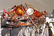
|File:Mars Polar Lander close-up.jpg|The spacecraft in stowed position just prior to encapsulation |
|||
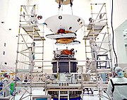
|File:Mars Polar Lander undergoes testing.jpg|Testing performed at the Spacecraft Assembly and Encapsulation Facility |
|||
|File:Mars Polar Lander prelaunch.jpg|The ''Mars Polar Lander'' entry capsule, just prior to being mounted to the [[Star 48]] upper stage |
|||
}} |
|||
; [[Mars Descent Imager#Mars Descent Imager (MARDI)|Mars Descent Imager]] (MARDI): Mounted to the bottom of the lander, the camera was intended to capture 30 images as the spacecraft descended to the surface. The images acquired would be used to provide geographic and geologic context to the landing area.<ref name="NSSDCMARDI">{{cite web |url= https://nssdc.gsfc.nasa.gov/nmc/experiment/display.action?id=1999-001A-02|title= Mars Descent Imager (MARDI)|publisher= NASA/National Space Science Data Center|access-date= March 17, 2011}}</ref> |
|||
; [[Phoenix (spacecraft)#Surface stereo imager|Surface Stereo Imager]] (SSI): Using a pair of [[charge coupled device]]s (CCD), the stereo [[panoramic camera]] was mounted to a one-meter-tall mast and would aid in the thermal evolved gas analyzer in determining areas of interest for the robotic arm. In addition, the camera would be used to estimate the column density of atmospheric dust, the optical depth of [[aerosol]]s, and slant column abundances of water vapor using narrow-band imaging of the Sun.<ref name="NSSDCMVACS">{{cite web |url=https://nssdc.gsfc.nasa.gov/nmc/experiment/display.action?id=1999-001A-01 |title=Mars Volatiles and Climate Surveyor (MVACS) |publisher= NASA/National Space Science Data Center|access-date= March 17, 2011}}</ref> |
|||
; [[Lidar|Light Detection and Ranging]] (LIDAR): The laser sounding instrument was intended to detect and characterize aerosols in the atmosphere up to three kilometers above the lander. The instrument operated in two modes: ''active mode'', using an included laser diode, and ''acoustic'' mode, using the Sun as the light source for the sensor. In active mode, the laser sounder was to emit 100-nanosecond pulses at a wavelength of 0.88-micrometer into the atmosphere, and then record the duration of time to detect the light scattered by aerosols. The duration of time required for the light to return could then be used to determine the abundance of ice, dust and other aerosols in the region. In acoustic mode, the instrument measures the brightness of the sky as lit by the Sun and records the scattering of light as it passes to the sensor.<ref name="NSSDCLIDAR">{{cite web |url=https://nssdc.gsfc.nasa.gov/nmc/experiment/display.action?id=1999-001A-03 |title=Light Detection and Ranging (LIDAR) |publisher= NASA/National Space Science Data Center|access-date= March 17, 2011}}</ref> |
|||
; [[Robotic arm|Robotic Arm]] (RA): Located on the front of the lander, the robotic arm was a meter-long aluminum tube with an elbow joint and an articulated scoop attached to the end. The scoop was intended to be used to dig into the soil in the direct vicinity of the lander. The soil could then be analyzed in the scoop with the robotic arm camera or transferred into the thermal evolved gas analyzer.<ref name="NSSDCMVACS" /> |
|||
; Robotic Arm Camera (RAC): Located on the robotic arm, the charge coupled camera included two red, two green, and four blue lamps to illuminate soil samples for analysis.<ref name="NSSDCMVACS" /> |
|||
; Meteorological Package (MET): Several instruments related to sensing and recording weather patterns, were included in the package. Wind, temperature, pressure, and humidity sensors were located on the robotic arm and two deployable masts: a 1.2-meter ''main mast'', located on top of the lander, and a 0.9-meter secondary ''submast'' that would deploy downward to acquire measurements close to the ground.<ref name="NSSDCMVACS" /> |
|||
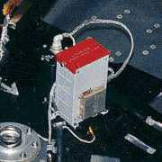
; [[Thermal and Evolved Gas Analyzer]] (TEGA): The instrument was intended to measure abundances of water, water ice, adsorbed carbon dioxide, oxygen, and volatile-bearing minerals in surface and subsurface soil samples collected and transferred by the robotic arm. Materials placed onto a grate inside one of the eight ovens, would be heated and vaporized at 1,000 °C. The evolved gas analyzer would then record measurements using a [[spectrometer]] and an [[Electrochemistry|electrochemical]] cell. For calibration, an empty oven would also be heated during this process for differential scanning [[calorimetry]]. The difference in the energy required to heat each oven would then indicate concentrations of water ice and other minerals containing water or carbon dioxide.<ref name="NSSDCMVACS" /> |
|||
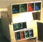
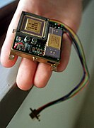
; Mars Microphone: The microphone was intended to be the first instrument to record sounds on another planet. Primarily composed of a microphone generally used with [[hearing aid]]s, the instrument was expected to record sounds of blowing dust, electrical discharges and the sounds of the operating spacecraft in either 2.6-second or 10.6-second, 12-bit samples.<ref name="NSSDCMIC">{{cite web |url=https://nssdc.gsfc.nasa.gov/nmc/experiment/display.action?id=1999-001A-04 |title=Mars Microphone |publisher= NASA/National Space Science Data Center|access-date= March 17, 2011}}</ref> The microphone was built using off-the-shelf parts including a [[Sensory, Inc.]] RSC-164 integrated circuit typically used in speech-recognition devices.<ref name="Planetary Society article">{{Cite web |url=http://www.planetary.org/programs/projects/planetary_microphones/mars_microphone.html |publisher=[[The Planetary Society]] |title=Projects: Planetary Microphones -- The Mars Microphone |archive-url=https://web.archive.org/web/20060818152601/http://www.planetary.org/programs/projects/planetary_microphones/mars_microphone.html |archive-date=August 18, 2006}}</ref> |
|||
== Mission profile == |
|||
{| style="float: right;" |
|||
! colspan="2" | Timeline of observations |
|||
|- |
|||
| |
|||
{| cellspacing="0" cellpadding="0" align="center" width="100%" style="border:0px solid #e6e6e6" |
|||
|- |
|||
| colspan="2" | |
|||
---- |
|||
|- |
|||
! scope="col" width="75" | Date |
|||
! scope="col" width="350" | Event |
|||
|- |
|||
| colspan="2" | |
|||
---- |
|||
<!--Main table data-outside collapsible--> |
|||
|- |
|||
| {{center|1999-01-03}} |
|||
| style="background-color:#f2f2f2;" | Spacecraft launched at 20:21:10 UTC |
|||
|- |
|||
| {{center|1999-12-03}} |
|||
| |
|||
<!--Collapsable data header--> |
|||
{| class="collapsible collapsed" align="center" width="100%" |
|||
! colspan="2" style="background-color:#e9e9e9;font-weight:normal;" | {{pad|2em}} Begin atmospheric entry and landing |
|||
|- |
|||
| colspan="2" | |
|||
---- |
|||
|- style="background-color:#e0e0e0" |
|||
! scope="col" width="75" | Time |
|||
! scope="col" width="230" | Event {{pad|6em}} |
|||
|- |
|||
| colspan="2" | |
|||
---- |
|||
<!--Collapsable data input-copy for more entries--> |
|||
|- |
|||
| {{center|'''1999-12-03'''}} |
|||
| |
|||
|- |
|||
| {{center|14:39:00}} |
|||
| {{small|Turn spacecraft away from Earth for final stellar data acquisition, signal loss from spacecraft}} |
|||
|- |
|||
| {{center|14:42:00}} |
|||
| {{small|Turn on heaters on descent engine}} |
|||
|- |
|||
| {{center|17:34:00}} |
|||
| {{small|Turn on heaters on descent camera (MARDI)}} |
|||
|- |
|||
| {{center|18:49:00}} |
|||
| {{small|Turn spacecraft back to Earth point, acquire spacecraft signal, acquire health & status}} |
|||
|- |
|||
| {{center|19:21:00}} |
|||
| {{small|Begin Entry, Descent, Landing sequence}} |
|||
|- |
|||
| {{center|19:26:00}} |
|||
| {{small|Pyros fire to pressurize helium tank}} |
|||
|- |
|||
| {{center|20:00:00}} |
|||
| {{small|Guidance system initialization (2210 km, 6.2 km/s)}} |
|||
|- |
|||
| {{center|20:03:00}} |
|||
| {{small|Turn spacecraft to entry attitude, loss of signal. We won't hear from the spacecraft again until after landing (1426 km, 6.4 km/s)}} |
|||
|- |
|||
| {{center|20:05:00}} |
|||
| {{small|Cruise ring/Deep Space 2 probes separate from lander (959 km, 6.6 km/s)}} |
|||
|- |
|||
| {{center|20:10:00}} |
|||
| {{small|Atmospheric entry (142 km, 6.9 km/s)}} |
|||
|- |
|||
| {{center|20:11:00}} |
|||
| {{small|Descent radar powered on}} |
|||
|- |
|||
| {{center|20:12:00}} |
|||
| {{small|MARDI instrument powered on}} |
|||
|- |
|||
| {{center|20:13:00}} |
|||
| {{small|Parachute deployed (9.0 km, 496 m/s)}} |
|||
|- |
|||
| {{center|20:13:00}} |
|||
| {{small|Descent imaging begins, heatshield jettisoned (8.0 km, 286 m/s)}} |
|||
|- |
|||
| {{center|20:13:00}} |
|||
| {{small|Lander legs deployed, descent radar activated}} |
|||
|- |
|||
| {{center|20:14}} |
|||
| {{small|Radar ground acquisition, altitude (2.438 km, 80 m/s)}} |
|||
|- |
|||
| {{center|20:14:00}} |
|||
| {{small|Lander separates from backshell, powered descent begins (1.628 km, 78 m/s)}} |
|||
|- |
|||
| {{center|20:14:00}} |
|||
| {{small|Radar ground acquisition, speed & direction (1.425 km, 82 m/s)}} |
|||
|- |
|||
| {{center|20:14}} |
|||
| {{small|Gravity turn begins (1.394 km, 83 m/s)}} |
|||
|- |
|||
| {{center|20:14:00}} |
|||
| {{small|Roll to landed orientation (1.307 km, 79 m/s)}} |
|||
|- |
|||
| {{center|20:14:00}} |
|||
| {{small|Radar cutoff (40 meters, 13 m/s)}} |
|||
|- |
|||
| {{center|20:15:00}} |
|||
| {{small|Constant Velocity Phase (12 meters, 2.4 m/s)}} |
|||
|- |
|||
| {{center|20:15:00}} |
|||
| {{fontcolor|red|{{small|'''Touchdown. Mars Polar Lander on Mars surface.'''}}}} |
|||
|- |
|||
| {{center|20:20:00}} |
|||
| {{fontcolor|red|{{small|Lander unfolds solar panels}}}} |
|||
|- |
|||
| {{center|20:20:00}} |
|||
| {{fontcolor|red|{{small|Medium gain antenna pointed at Earth}}}} |
|||
|- |
|||
| {{center|20:39:00}} |
|||
| {{fontcolor|red|{{small|'''Lander begins 1st transmission to Earth (45 minutes). Sends health & status, meteorology & 1 b/w image'''}}}} |
|||
|- |
|||
| {{center|21:24:00}} |
|||
| {{fontcolor|red|{{small|Lander ends transmission to Earth}}}} |
|||
|- |
|||
| {{center|21:45:00}} |
|||
| {{fontcolor|red|{{small|Lander powers down to sleep so it can recharge}}}} |
|||
|- |
|||
| {{center|22:10:00}} |
|||
| {{fontcolor|red|{{small|Start of 1 hour backup downlink opportunity (if spacecraft went into safemode during landing)}}}} |
|||
|- |
|||
| {{center|'''1999-12-04'''}} |
|||
| |
|||
|- |
|||
| {{center|02:50:00}} |
|||
| {{fontcolor|red|{{small|Lander wakes up, receives instructions from Earth}}}} |
|||
|- |
|||
| {{center|03:25:00}} |
|||
| {{fontcolor|red|{{small|'''Begin DS2 microprobe data reception via Mars Global Surveyor relay (15 minute transmission)'''}}}} |
|||
|- |
|||
| {{center|04:25:00}} |
|||
| {{fontcolor|red|{{small|2.5 hour downlink begins, could include lander and descent images}}}} |
|||
|- |
|||
| {{center|06:25:00}} |
|||
| {{fontcolor|red|{{small|Lander shuts itself down until next day. End of Sol 0 activities.}}}} |
|||
|- |
|||
| colspan="2" | {{center|<small>Items in {{fontcolor|red|'''red'''}} were planned events.</small>}} |
|||
|} |
|||
|- |
|||
| {{center|1999-12-03}} |
|||
| |
|||
<!--Collapsable data header--> |
|||
{| class="collapsible collapsed" align="center" width="100%" |
|||
! colspan="2" style="background-color:#e9e9e9;font-weight:normal;" | Failure to regain communication after landing |
|||
|- |
|||
| colspan="2" | |
|||
---- |
|||
|- style="background-color:#e0e0e0" |
|||
! scope="col" width="75" | Time |
|||
! scope="col" width="230" | Event {{pad|6em}} |
|||
|- |
|||
| colspan="2" | |
|||
---- |
|||
<!--Collapsable data input-copy for more entries--> |
|||
|- |
|||
| {{center|'''1999-12-03'''}} |
|||
| |
|||
|- |
|||
| {{center|20:39:00}} |
|||
| {{small|First communication from lander missed}} |
|||
|- |
|||
| {{center|22:04:00}} |
|||
| {{small|Second communication from lander missed}} |
|||
|- |
|||
| {{center|'''1999-12-04'''}} |
|||
| |
|||
|- |
|||
| {{center|04:08:00}} |
|||
| {{small|Third communication from lander missed}} |
|||
|- |
|||
| {{center|'''1999-12-05'''}} |
|||
| |
|||
|- |
|||
| {{center|04:30:00}} |
|||
| {{small|Fourth communication from lander missed}} |
|||
|- |
|||
| {{center|18:50:00}} |
|||
| {{small|First attempt to detect automatic fail-safe UHF communication to Mars Global Surveyor failed}} |
|||
|- |
|||
| {{center|'''1999-12-06'''}} |
|||
| |
|||
|- |
|||
| {{center|06:10:00}} |
|||
| {{small|Second attempt to detect automatic fail-safe UHF communication to Mars Global Surveyor failed}} |
|||
|- |
|||
| {{center|'''1999-12-07'''}} |
|||
| |
|||
|- |
|||
| {{center|08:20:00}} |
|||
| {{small|Third attempt to detect automatic fail-safe UHF communication to Mars Global Surveyor failed}} |
|||
|- |
|||
| {{center|'''1999-12-08'''}} |
|||
| {{small|Radio sweeps of the surface by the Deep Space Network failed. Repeat of prior procedures to exhaust all possibilities of regaining contact.}} |
|||
|} |
|||
|- |
|||
| {{center|2000-01-17}} |
|||
| style="background-color:#f2f2f2;" | Mission declared a loss. No further attempts to contact. |
|||
|} |
|||
|} |
|||
=== Launch and trajectory === |
|||
''Mars Polar Lander'' was launched on January 3, 1999, at 20:21:10 UTC by the [[National Aeronautics and Space Administration]] from [[Cape Canaveral Air Force Station Space Launch Complex 17|Space Launch Complex 17B]] at the [[Cape Canaveral Air Force Station]] in Florida, aboard a [[Delta II]] 7425–9.5 launch vehicle. The complete burn sequence lasted for 47.7 minutes after a [[Thiokol]] [[Star 48]]B solid-fuel third stage booster placed the spacecraft into an 11-month, Mars transfer trajectory at a final velocity of 6.884 kilometers per second with respect to Mars. During cruise, the spacecraft was stowed inside an [[aeroshell]] capsule and a segment known as the ''cruise stage'' provided power and communications with Earth.<ref name="Surveyor98Launch" /><ref name="MPLDS2Landing">{{cite press release| publisher=NASA| year=1999| title=Mars Polar Lander/Deep Space 2 Press Kit| url=http://www.jpl.nasa.gov/files/misc/mpl-ds2hq.pdf| access-date=March 12, 2011| archive-date=2016-12-23 | archive-url=https://web.archive.org/web/20161223235619/http://www2.jpl.nasa.gov/files/misc/mpl-ds2hq.pdf| url-status=dead}}</ref><ref name='NSSDCMissionInfo' />{{Clear}} |
|||
<!--Gallery of launch and trajectories at end of section--> |
|||
{{Gallery|align=center |
|||
|width=175 |File:Mars Polar Lander - launch configuration diagram.png|alt1=Diagram of the configured positions of Mars Polar Lander within a Delta II launch vehicle |{{small|Launch configuration diagram.}} |
|||
|File:Mars Polar Lander - launch photo.png|alt2=Launch photo of Mars Polar Lander being lifted into space by a Delta II launch vehicle |{{small|Launch photo of Mars Polar Lander aboard a Delta II launch vehicle.}} |
|||
|File:Mars Polar Lander - interplanetary trajectory.png|alt3=Diagram of the interplanetary trajectory of Mars Polar Lander |{{small|Diagram of the interplanetary trajectory of Mars Polar Lander.}} |
|||
}} |
|||
=== Landing zone === |
|||
The target landing zone was a region near the [[Planum Australe|south pole]] of Mars, called ''Ultimi Scopuli'', because it featured a large number of [[Scopulus|scopuli]] ([[wikt:lobe|lobate]] or irregular [[escarpment|scarps]]).{{citation needed|date=July 2016}} |
|||
=== Landing attempt === |
|||
{{further|Exploration of Mars}} |
|||
{{multiple image |
|||
| footer = Mars Polar Lander entered the Martian atmosphere with an aeroshell for protection from atmospheric friction. |
|||
| image1 = Mars Polar Lander - cruise configuration.png |
|||
| width1 = 90 |
|||
| alt1 = Cruise configuration diagram of Mars Polar Lander. |
|||
| caption1 = <small>Cruise configuration</small> |
|||
| image2 = Mars Polar Lander - landing diagram.png |
|||
| width2 = 102 |
|||
| alt2 = Diagram of landing procedures of Mars Polar Lander as it would pass through the atmosphere and land on the surface. |
|||
| caption2 = <small>Landing procedure</small> |
|||
| image3 = Mars Polar Lander - targeted landing sector.png |
|||
| width3 = 84 |
|||
| alt3 = Map of the region targeted for landing by the Mars Polar Lander. |
|||
| caption3 = <small>Landing region</small> |
|||
}} |
|||
On December 3, 1999, ''Mars Polar Lander'' arrived at Mars and mission operators began preparations for landing. At 14:39:00 UTC, the cruise stage was jettisoned, which began a planned communication dropout to last until the spacecraft had touched down on the surface. Six minutes prior to atmospheric entry, a programmed 80-second thruster firing turned the spacecraft to the proper entry orientation, with the [[heat shield]] positioned to absorb the 1,650 °C heat that would be generated as the descent capsule passed through the atmosphere. |
|||
Traveling at 6.9 kilometers per second, the entry capsule entered the [[Atmosphere of Mars|Martian atmosphere]] at 20:10:00 UTC, and was expected to land in the vicinity of {{Coord|76|S|195|W|globe:Mars|name=Mars Polar Lander}} in a region known as [[Planum Australe]]. Reestablishment of communication was anticipated for 20:39:00 UTC, after landing. However communication was not reestablished, and the lander was declared lost.<ref name="Surveyor98Launch" /><ref name="MPLDS2Landing" /><ref name='NSSDCMissionInfo' /> |
|||
On May 25, 2008, the [[Phoenix (spacecraft)|Phoenix]] lander arrived at Mars, and has subsequently completed most of the objectives of the ''Mars Polar Lander'', carrying several of the same or derivative instruments. |
|||
{{Features and artificial objects on Mars}} |
|||
=== Intended operations === |
|||
Traveling at approximately 6.9 kilometers/second and 125 kilometers above the surface, the spacecraft entered the atmosphere and was initially decelerated by using a 2.4 meter [[ablation]] [[heat shield]], located on the bottom of the entry body, to [[aerobrake]] through 116 kilometers of the atmosphere. Three minutes after entry, the spacecraft had slowed to 496 meters per second signaling an 8.4-meter, [[polyester]] parachute to deploy from a mortar followed immediately by heat shield separation and MARDI powering on, while 8.8 kilometers above the surface. The parachute further slowed the speed of the spacecraft to 85 meters per second when the ground radar began tracking surface features to detect the best possible landing location. |
|||
When the spacecraft had slowed to 80 meters per second, one minute after parachute deployment, the lander separated from the backshell and began a powered descent while 1.3 kilometers aloft. The powered descent was expected to have lasted approximately one minute, bringing the spacecraft 12 meters above the surface. The engines were then shut off and the spacecraft would expectedly fall to the surface and land at 20:15:00 UTC near 76°S 195°W in Planum Australe.<ref name="Surveyor98Launch" /><ref name="MPLDS2Landing" /><ref name='NSSDCMissionInfo' /><ref name="MPLWebsiteSpacecraftInfo" /> |
|||
Lander operations were to begin five minutes after touchdown, first unfolding the stowed solar arrays, followed by orienting the medium-gain, direct-to-Earth antenna to allow for the first communication with the [[Deep Space Network]]. At 20:39 UTC, a 45-minute transmission was to be broadcast to Earth, transmitting the expected 30 landing images acquired by MARDI and signaling a successful landing. The lander would then power down for six hours to allow the batteries to charge. On the following days, the spacecraft instruments would be checked by operators and science experiments were to begin on December 7 and last for at least the following 90 [[Timekeeping on Mars#Sols|Martian Sols]], with the possibility of an extended mission.<ref name="Surveyor98Launch" /><ref name="MPLDS2Landing" /><ref name='NSSDCMissionInfo' /><ref name="MPLWebsiteSpacecraftInfo" /> |
|||
== Loss of communications == |
|||
On December 3, 1999, at 14:39:00 UTC, the last [[telemetry]] from ''Mars Polar Lander'' was sent, just prior to cruise stage separation and the subsequent atmospheric entry. No further signals were received from the spacecraft. Attempts were made by [[Mars Global Surveyor]] to photograph the area in which the lander was believed to be. An object was visible and believed to be the lander. However, subsequent imaging performed by [[Mars Reconnaissance Orbiter]] resulted in the identified object being ruled out. ''Mars Polar Lander'' remains lost.<ref>{{cite news | title=Mars Polar Lander Found at Last? | url=http://skyandtelescope.com/news/article_1509_1.asp | work=[[Sky and Telescope]] | date=May 6, 2005 | access-date=April 22, 2009 | archive-url=https://web.archive.org/web/20080723233112/http://skyandtelescope.com/news/article_1509_1.asp | archive-date=July 23, 2008 | url-status=dead }}</ref><ref>{{cite web | title=Release No. MOC2-1253: Mars Polar Lander NOT Found | url=http://www.msss.com/mars_images/moc/2005/10/17/ | work=Mars Global Surveyor / Mars Orbiter Camera | publisher=NASA/JPL/Malin Space Science Systems | date=October 17, 2005 | access-date=April 22, 2009 | archive-url=https://web.archive.org/web/20081207053229/http://www.msss.com/mars_images/moc/2005/10/17/ | archive-date=December 7, 2008 | url-status=dead }}</ref> |
|||
The cause of the communication loss is not known. However, the Failure Review Board concluded that the most likely cause of the mishap was a software error that incorrectly identified vibrations, caused by the deployment of the stowed legs, as surface touchdown.<ref name="NASA 3: Mission Failures">{{cite AV media |url=https://www.youtube.com/watch?v=YJ6pbCHpXEI |archive-url=https://ghostarchive.org/varchive/youtube/20211221/YJ6pbCHpXEI |archive-date=2021-12-21 |url-status=live|publisher=Youtube |title=NASA 3: Mission Failures}}{{cbignore}}</ref> The resulting action by the spacecraft was the shutdown of the descent engines, while still likely 40 meters above the surface. Although it was known that leg deployment could create the false indication, the software's design instructions did not account for that eventuality.<ref>{{cite report | author=Nancy G. Leveson | title=The Role of Software in Recent Aerospace Accidents| url=http://sunnyday.mit.edu/accidents/issc01.pdf}}</ref> |
|||
In addition to the premature shutdown of the descent engines, the Failure Review Board also assessed other potential modes of failure.<ref name="LossReport" /> Lacking substantial evidence for the mode of failure, the following possibilities could not be excluded: |
|||
* surface conditions exceed landing design capabilities; |
|||
* loss of control due to dynamic effects; |
|||
* landing site not survivable; |
|||
* backshell/parachute contacts lander; |
|||
* loss of control due to center-of-mass offset; or |
|||
* heatshield fails due to [[micrometeoroid]] impact. |
|||
The failure of the Mars Polar Lander took place two and a half months after the loss of the [[Mars Climate Orbiter]]. Inadequate funding and poor management have been cited as underlying causes of the failures.<ref>{{cite report | author=Thomas Young | title=Mars Program Independent Assessment Team Summary Report | version=Draft #7 3/13/00 | publisher=House Science and Technology Committee | url=http://www.spaceref.com/news/viewpr.html?pid=1444 | date=March 14, 2000 | access-date=April 22, 2009}}</ref> According to Thomas Young, chairman of the Mars Program Independent Assessment Team, the program "was under funded by at least 30%."<ref>{{cite news | author=Jeffrey Kaye | title=NASA in the Hot Seat | url=https://www.pbs.org/newshour/bb/science/jan-june00/nasa_4-14.html | format=transcript | work=NewsHour with Jim Lehrer | publisher=PBS | date=April 14, 2000 | access-date=April 22, 2009 | archive-date=2013-12-26 | archive-url=https://web.archive.org/web/20131226075519/http://www.pbs.org/newshour/bb/science/jan-june00/nasa_4-14.html | url-status=dead }}</ref>'' |
|||
{| class="wikitable" style="margin:1em auto;" |
|||
! Quoted from the report<ref name="LossReport" /> |
|||
|- |
|||
| scope="col" width="750" | |
|||
"A magnetic sensor is provided in each of the three landing legs to sense touchdown when the lander contacts the surface, initiating the shutdown of the descent engines. Data from MPL engineering development unit deployment tests, MPL flight unit deployment tests, and Mars 2001 deployment tests showed that a spurious touchdown indication occurs in the [[Hall effect|Hall Effect]] touchdown sensor during landing leg deployment (while the lander is connected to the parachute). The software logic accepts this transient signal as a valid touchdown event if it persists for two consecutive readings of the sensor. The tests showed that most of the transient signals at leg deployment are indeed long enough to be accepted as valid events, therefore, it is almost a certainty that at least one of the three would have generated a spurious touchdown indication that the software accepted as valid. |
|||
The software—intended to ignore touchdown indications prior to the enabling of the touchdown sensing logic—was not properly implemented, and the spurious touchdown indication was retained. The touchdown sensing logic is enabled at 40 meters altitude, and the software would have issued a descent engine thrust termination at this time in response to a (spurious) touchdown indication. |
|||
At 40 meters altitude, the lander has a velocity of approximately 13 meters per second, which, in the absence of thrust, is accelerated by Mars gravity to a surface impact velocity of approximately 22 meters per second (the nominal touchdown velocity is 2.4 meters per second). At this impact velocity, the lander could not have survived." |
|||
|} |
|||
== Aftermath == |
|||
Despite the Mars Polar Lander's failure, [[Planum Australe]], which served as the exploration target for the lander and the two [[Deep Space 2]] probes,<ref>{{cite news|url=https://www.americaspace.com/2019/01/06/could-not-have-survived-20-years-since-nasas-ill-fated-mars-polar-lander/|title='Could Not Have Survived': 20 Years Since NASA's Ill-Fated Mars Polar Lander|first=Ben|last=Evans|publisher=AmericaSpace|date=2019|accessdate=15 April 2022}}</ref> would in later years be explored by European Space Agency's [[MARSIS]] radar, which examined and analyzed the site from Mars' orbit.<ref>{{cite journal |author=Orosei, R.|display-authors=etal|title=Radar evidence of subglacial liquid water on Mars |date=25 July 2018 |journal=[[Science (journal)|Science]] |volume=361 |issue=6401 |pages=490–493 |doi=10.1126/science.aar7268|arxiv=2004.04587 |pmid=30045881 |hdl=11573/1148029|doi-access=free |bibcode=2018Sci...361..490O }}</ref><ref>{{cite news |last1=Chang |first1=Kenneth |last2=Overbye |first2=Dennis |author-link2=Dennis Overbye |title=A Watery Lake Is Detected on Mars, Raising the Potential for Alien Life – The discovery suggests that watery conditions beneath the icy southern polar cap may have provided one of the critical building blocks for life on the red planet. |url=https://www.nytimes.com/2018/07/25/science/mars-liquid-alien-life.html |date=25 July 2018 |work=[[The New York Times]] |access-date=15 April 2022 }}</ref><ref>{{cite web |title=Huge reservoir of liquid water detected under the surface of Mars |url=https://www.eurekalert.org/pub_releases/2018-07/aaft-hro072318.php |work=[[EurekAlert]]|date=25 July 2018 |access-date=15 April 2022 }}</ref><ref>{{cite web |title=Liquid water 'lake' revealed on Mars |url=https://www.bbc.co.uk/news/science-environment-44952710 |work=[[BBC News]]|date=25 July 2018 |access-date=15 April 2022 }}</ref> |
|||
== See also == |
|||
{{Portal|Spaceflight}} |
|||
{{div col|colwidth=30em}} |
|||
* [[Mars Surveyor 2001 Lander]], similar design lander, mission cancelled. Lander used for Phoenix. |
|||
* [[Phoenix (spacecraft)|''Phoenix'' lander]], 2008 |
|||
* [[Exploration of Mars]] |
|||
* [[ExoMars]] rover |
|||
* [[List of missions to Mars]] |
|||
* [[Mars Science Laboratory]] rover |
|||
{{div col end}} |
|||
* [[List of software bugs#Space|List of software bugs]] |
|||
== References == |
|||
{{Reflist|2}} |
|||
== Further reading == |
|||
* {{cite web | title=Mars Polar Lander (1999-001A) | work=NSSDC Master Catalog | publisher=NASA | url=https://nssdc.gsfc.nasa.gov/nmc/spacecraft/display.action?id=1999-001A | year=2001 | access-date=April 22, 2009}} |
|||
* {{cite journal | author=Michael C. Malin | title=Hidden in Plain Sight: Finding Martian Landers | journal=Sky and Telescope | volume=110 | issue=7| date=July 2005 | pages=42–46 | bibcode=2005S&T...110a..42M | issn=0037-6604}} |
|||
* {{cite press release | title=Press Kit: 1998 Mars Missions | format=.PDF | publisher=National Aeronautics and Space Administration | url=http://www2.jpl.nasa.gov/files/misc/mars98launch.pdf | date=December 8, 1998 | access-date=April 22, 2009}} |
|||
== External links == |
|||
{{Commons category}} |
|||
* [https://web.archive.org/web/20120904172310/http://mpfwww.jpl.nasa.gov/msp98/ Mars Polar Lander site] at [[Jet Propulsion Laboratory]] |
|||
* [https://web.archive.org/web/20120927163919/http://solarsystem.nasa.gov/missions/profile.cfm?MCode=MPL Mars Polar Lander Mission] at The NASA Solar System Exploration Home Page |
|||
* Report of the Loss of the Mars Polar Lander and Deep Space 2 Missions |
|||
**[https://web.archive.org/web/20151213144426/ftp://ftp.hq.nasa.gov/pub/pao/reports/2000/2000_mpl_report_1.pdf (Part 1)] |
|||
**[https://web.archive.org/web/20151213144426/ftp://ftp.hq.nasa.gov/pub/pao/reports/2000/2000_mpl_report_2.pdf (Part 2)] |
|||
**[https://web.archive.org/web/20151213144426/ftp://ftp.hq.nasa.gov/pub/pao/reports/2000/2000_mpl_report_3.pdf (Part 3)] |
|||
**[https://web.archive.org/web/20151213144426/ftp://ftp.hq.nasa.gov/pub/pao/reports/2000/2000_mpl_report_4.pdf (Part 4)] |
|||
**[https://web.archive.org/web/20151213144426/ftp://ftp.hq.nasa.gov/pub/pao/reports/2000/2000_mpl_report_5.pdf (Part 5)] |
|||
{{Mars}} |
|||
{{Mars spacecraft}} |
|||
{{Orbital launches in 1999}} |
|||
{{Jet Propulsion Laboratory}} |
|||
[[Category:Missions to Mars]] |
|||
[[Category:NASA space probes]] |
|||
[[Category:Derelict landers (spacecraft)]] |
|||
[[Category:Mare Australe quadrangle]] |
|||
[[Category:Spacecraft launched in 1999]] |
|||
[[Category:Spacecraft launched by Delta II rockets]] |
|||
[[Category:Space accidents and incidents in the United States]] |
|||
[[Category:Attached spacecraft]] |
|||
[[Category:1999 on Mars]] |
|||
Latest revision as of 22:11, 30 December 2023
 Artist's depiction of the Mars Polar Lander on Mars | |
| Names | Mars Surveyor '98 |
|---|---|
| Mission type | Lander |
| Operator | NASA / JPL |
| COSPAR ID | 1999-001A |
| SATCAT no. | 25605 |
| Website | Mars Polar Lander website |
| Mission duration | 334 days Mission failure |
| Spacecraft properties | |
| Manufacturer | Martin Marietta |
| Launch mass | 583 kg[1] |
| Power | 200 W solar array and NiH2 battery |
| Start of mission | |
| Launch date | 20:21:10, January 3, 1999 (UTC) |
| Rocket | Delta II 7425-9.5 |
| Launch site | Cape Canaveral AFS SLC-17A |
| End of mission | |
| Disposal | communication failure after landing |
| Declared | January 17, 2000 |
| Last contact | 20:00, December 3, 1999 (UTC) |
| Mars lander | |
| Landing date | ~20:15 UTC ERT, December 3, 1999 |
| Landing site | Ultimi Scopuli, 76°S 195°W / 76°S 195°W (projected) |
 Mars Surveyor 98 mission logo | |
The Mars Polar Lander, also known as the Mars Surveyor '98 Lander, was a 290-kilogram robotic spacecraft lander launched by NASA on January 3, 1999, to study the soil and climate of Planum Australe, a region near the south pole on Mars. It formed part of the Mars Surveyor '98 mission. On December 3, 1999, however, after the descent phase was expected to be complete, the lander failed to reestablish communication with Earth. A post-mortem analysis determined the most likely cause of the mishap was premature termination of the engine firing prior to the lander touching the surface, causing it to strike the planet at a high velocity.[2]
The total cost of the Mars Polar Lander was US$165 million. Spacecraft development cost US$110 million, launch was estimated at US$45 million, and mission operations at US$10 million.[3]
Mission background[edit]
History[edit]
As part of the Mars Surveyor '98 mission, a lander was sought as a way to gather climate data from the ground in conjunction with an orbiter. NASA suspected that a large quantity of frozen water may exist under a thin layer of dust at the south pole. In planning the Mars Polar Lander, the potential water content in the Martian south pole was the strongest determining factor for choosing a landing location.[4] A CD-ROM containing the names of one million children from around the world was placed on board the spacecraft as part of the "Send Your Name to Mars" program designed to encourage interest in the space program among children.[5]
The primary objectives of the mission were to:[6]
- land on the layered terrain in the south polar region of Mars;
- search for evidence related to ancient climates and more recent periodic climate change;
- give a picture of the current climate and seasonal change at high latitudes and, in particular, the exchange of water vapor between the atmosphere and ground;
- search for near-surface ground ice in the polar regions, and analyze the soil for physically and chemically bound carbon dioxide and water; and
- study surface morphology (forms and structures), geology, topography, and weather of the landing site.
Deep Space 2 probes[edit]
The Mars Polar Lander carried two small, identical impactor probes known as "Deep Space 2 A and B". The probes were intended to strike the surface with a high velocity at approximately 73°S 210°W / 73°S 210°W to penetrate the Martian soil and study the subsurface composition up to a meter in depth. However, after entering the Martian atmosphere, attempts to contact the probes failed.[4]
Deep Space 2 was funded by the New Millennium Program, and their development costs was US$28 million.[3]
Spacecraft design[edit]
The spacecraft measured 3.6 meters wide and 1.06 meters tall with the legs and solar arrays fully deployed. The base was primarily constructed with an aluminum honeycomb deck, composite graphite–epoxy sheets forming the edge, and three aluminum legs. During landing, the legs were to deploy from stowed position with compression springs and absorb the force of the landing with crushable aluminum honeycomb inserts in each leg. On the deck of the lander, a small thermal Faraday cage enclosure housed the computer, power distribution electronics and batteries, telecommunication electronics, and the capillary pump loop heat pipe (LHP) components, which maintained operable temperature. Each of these components included redundant units in the event that one may fail.[4][7][8]
Attitude control and propulsion[edit]
While traveling to Mars, the cruise stage was three-axis stabilized with four hydrazine monopropellant reaction engine modules, each including a 22-newton trajectory correction maneuver thruster for propulsion and a 4-newton reaction control system thruster for attitude control (orientation). Orientation of the spacecraft was performed using redundant Sun sensors, star trackers, and inertial measurement units.[7]
During descent, the lander used three clusters of pulse modulated engines, each containing four 266-newton hydrazine monopropellant thrusters. Altitude during landing was measured by a doppler radar system, and an attitude and articulation control subsystem (AACS) controlled the attitude to ensure the spacecraft landed at the optimal azimuth to maximize solar collection and telecommunication with the lander.[4][7][8]
The lander was launched with two hydrazine tanks containing 64 kilograms of propellant and pressurized using helium. Each spherical tank was located at the underside of the lander and provided propellant during the cruise and descent stages.[4][7][8]
Communications[edit]
During the cruise stage, communications with the spacecraft were conducted over the X band using a medium-gain, horn-shaped antenna and redundant solid state power amplifiers. For contingency measures, a low-gain omni-directional antenna was also included.[4]
The lander was originally intended to communicate data through the failed Mars Climate Orbiter via the UHF antenna. With the orbiter lost on September 23, 1999, the lander would still be able to communicate directly to the Deep Space Network through the Direct-To-Earth (DTE) link, an X band, steerable, medium-gain, parabolic antenna located on the deck. Alternatively, Mars Global Surveyor could be used as a relay using the UHF antenna at multiple times each Martian day. However the Deep Space Network could only receive data from, and not send commands to, the lander using this method. The direct-to-Earth medium-gain antenna provided a 12.6-kbit/s return channel, and the UHF relay path provided a 128-kbit/s return channel. Communications with the spacecraft would be limited to one-hour events, constrained by heat-buildup that would occur in the amplifiers. The number of communication events would also be constrained by power limitations.[4][6][7][8]
Power[edit]
The cruise stage included two gallium arsenide solar arrays to power the radio system and maintain power to the batteries in the lander, which kept certain electronics warm.[4][7]
After descending to the surface, the lander was to deploy two 3.6-meter-wide gallium arsenide solar arrays, located on either side of the spacecraft. Another two auxiliary solar arrays were located on the side to provide additional power for a total of an expected 200 watts and approximately eight to nine hours of operating time per day.[4][7]
While the Sun would not have set below the horizon during the primary mission, too little light would have reached the solar arrays to remain warm enough for certain electronics to continue functioning. To avoid this problem, a 16-amp-hour nickel hydrogen battery was included to be recharged during the day and to power the heater for the thermal enclosure at night. This solution also was expected to limit the life of the lander. As the Martian days would grow colder in late summer, too little power would be supplied to the heater to avoid freezing, resulting in the battery also freezing and signaling the end of the operating life for the lander.[4][7][8]
Scientific instruments[edit]
-
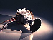 Mars Descent Imager
 -
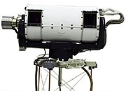 Stereo Surface Imager
 -
 LIDAR
LIDAR -
 Robotic Arm
 -
 Robotic Arm Camera
 -
 Meteorological Package
 -
 Thermal and Evolved Gas Analyzer
 -
 Mars Microphone


-
 Annotated diagram of the Mars Polar Lander spacecraft
 -
 The spacecraft in stowed position just prior to encapsulation
 -
 Testing performed at the Spacecraft Assembly and Encapsulation Facility
 -
 The Mars Polar Lander entry capsule, just prior to being mounted to the Star 48 upper stage


- Mars Descent Imager (MARDI)
- Mounted to the bottom of the lander, the camera was intended to capture 30 images as the spacecraft descended to the surface. The images acquired would be used to provide geographic and geologic context to the landing area.[9]
- Surface Stereo Imager (SSI)
- Using a pair of charge coupled devices (CCD), the stereo panoramic camera was mounted to a one-meter-tall mast and would aid in the thermal evolved gas analyzer in determining areas of interest for the robotic arm. In addition, the camera would be used to estimate the column density of atmospheric dust, the optical depth of aerosols, and slant column abundances of water vapor using narrow-band imaging of the Sun.[10]
- Light Detection and Ranging (LIDAR)
- The laser sounding instrument was intended to detect and characterize aerosols in the atmosphere up to three kilometers above the lander. The instrument operated in two modes: active mode, using an included laser diode, and acoustic mode, using the Sun as the light source for the sensor. In active mode, the laser sounder was to emit 100-nanosecond pulses at a wavelength of 0.88-micrometer into the atmosphere, and then record the duration of time to detect the light scattered by aerosols. The duration of time required for the light to return could then be used to determine the abundance of ice, dust and other aerosols in the region. In acoustic mode, the instrument measures the brightness of the sky as lit by the Sun and records the scattering of light as it passes to the sensor.[11]
- Robotic Arm (RA)
- Located on the front of the lander, the robotic arm was a meter-long aluminum tube with an elbow joint and an articulated scoop attached to the end. The scoop was intended to be used to dig into the soil in the direct vicinity of the lander. The soil could then be analyzed in the scoop with the robotic arm camera or transferred into the thermal evolved gas analyzer.[10]
- Robotic Arm Camera (RAC)
- Located on the robotic arm, the charge coupled camera included two red, two green, and four blue lamps to illuminate soil samples for analysis.[10]
- Meteorological Package (MET)
- Several instruments related to sensing and recording weather patterns, were included in the package. Wind, temperature, pressure, and humidity sensors were located on the robotic arm and two deployable masts: a 1.2-meter main mast, located on top of the lander, and a 0.9-meter secondary submast that would deploy downward to acquire measurements close to the ground.[10]
- Thermal and Evolved Gas Analyzer (TEGA)
- The instrument was intended to measure abundances of water, water ice, adsorbed carbon dioxide, oxygen, and volatile-bearing minerals in surface and subsurface soil samples collected and transferred by the robotic arm. Materials placed onto a grate inside one of the eight ovens, would be heated and vaporized at 1,000 °C. The evolved gas analyzer would then record measurements using a spectrometer and an electrochemical cell. For calibration, an empty oven would also be heated during this process for differential scanning calorimetry. The difference in the energy required to heat each oven would then indicate concentrations of water ice and other minerals containing water or carbon dioxide.[10]
- Mars Microphone
- The microphone was intended to be the first instrument to record sounds on another planet. Primarily composed of a microphone generally used with hearing aids, the instrument was expected to record sounds of blowing dust, electrical discharges and the sounds of the operating spacecraft in either 2.6-second or 10.6-second, 12-bit samples.[12] The microphone was built using off-the-shelf parts including a Sensory, Inc. RSC-164 integrated circuit typically used in speech-recognition devices.[13]
Mission profile[edit]
| Timeline of observations | ||||||||||||||||||||||||||||||||||||||||||||||||||||||||||||||||||||||||||||||||||||||||||||||||||||||||||||||||||||||||||||||||
|---|---|---|---|---|---|---|---|---|---|---|---|---|---|---|---|---|---|---|---|---|---|---|---|---|---|---|---|---|---|---|---|---|---|---|---|---|---|---|---|---|---|---|---|---|---|---|---|---|---|---|---|---|---|---|---|---|---|---|---|---|---|---|---|---|---|---|---|---|---|---|---|---|---|---|---|---|---|---|---|---|---|---|---|---|---|---|---|---|---|---|---|---|---|---|---|---|---|---|---|---|---|---|---|---|---|---|---|---|---|---|---|---|---|---|---|---|---|---|---|---|---|---|---|---|---|---|---|---|
| ||||||||||||||||||||||||||||||||||||||||||||||||||||||||||||||||||||||||||||||||||||||||||||||||||||||||||||||||||||||||||||||||
Launch and trajectory[edit]
Mars Polar Lander was launched on January 3, 1999, at 20:21:10 UTC by the National Aeronautics and Space Administration from Space Launch Complex 17B at the Cape Canaveral Air Force Station in Florida, aboard a Delta II 7425–9.5 launch vehicle. The complete burn sequence lasted for 47.7 minutes after a Thiokol Star 48B solid-fuel third stage booster placed the spacecraft into an 11-month, Mars transfer trajectory at a final velocity of 6.884 kilometers per second with respect to Mars. During cruise, the spacecraft was stowed inside an aeroshell capsule and a segment known as the cruise stage provided power and communications with Earth.[4][6][7]
-
 Launch configuration diagram.
 -
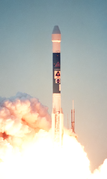 Launch photo of Mars Polar Lander aboard a Delta II launch vehicle.
 -
 Diagram of the interplanetary trajectory of Mars Polar Lander.


Landing zone[edit]
The target landing zone was a region near the south pole of Mars, called Ultimi Scopuli, because it featured a large number of scopuli (lobate or irregular scarps).[citation needed]
Landing attempt[edit]


On December 3, 1999, Mars Polar Lander arrived at Mars and mission operators began preparations for landing. At 14:39:00 UTC, the cruise stage was jettisoned, which began a planned communication dropout to last until the spacecraft had touched down on the surface. Six minutes prior to atmospheric entry, a programmed 80-second thruster firing turned the spacecraft to the proper entry orientation, with the heat shield positioned to absorb the 1,650 °C heat that would be generated as the descent capsule passed through the atmosphere.
Traveling at 6.9 kilometers per second, the entry capsule entered the Martian atmosphere at 20:10:00 UTC, and was expected to land in the vicinity of 76°S 195°W / 76°S 195°W in a region known as Planum Australe. Reestablishment of communication was anticipated for 20:39:00 UTC, after landing. However communication was not reestablished, and the lander was declared lost.[4][6][7]
On May 25, 2008, the Phoenix lander arrived at Mars, and has subsequently completed most of the objectives of the Mars Polar Lander, carrying several of the same or derivative instruments.

 Clickable image: Clicking on the labels will open a new article.
Intended operations[edit]
Traveling at approximately 6.9 kilometers/second and 125 kilometers above the surface, the spacecraft entered the atmosphere and was initially decelerated by using a 2.4 meter ablation heat shield, located on the bottom of the entry body, to aerobrake through 116 kilometers of the atmosphere. Three minutes after entry, the spacecraft had slowed to 496 meters per second signaling an 8.4-meter, polyester parachute to deploy from a mortar followed immediately by heat shield separation and MARDI powering on, while 8.8 kilometers above the surface. The parachute further slowed the speed of the spacecraft to 85 meters per second when the ground radar began tracking surface features to detect the best possible landing location.
When the spacecraft had slowed to 80 meters per second, one minute after parachute deployment, the lander separated from the backshell and began a powered descent while 1.3 kilometers aloft. The powered descent was expected to have lasted approximately one minute, bringing the spacecraft 12 meters above the surface. The engines were then shut off and the spacecraft would expectedly fall to the surface and land at 20:15:00 UTC near 76°S 195°W in Planum Australe.[4][6][7][8]
Lander operations were to begin five minutes after touchdown, first unfolding the stowed solar arrays, followed by orienting the medium-gain, direct-to-Earth antenna to allow for the first communication with the Deep Space Network. At 20:39 UTC, a 45-minute transmission was to be broadcast to Earth, transmitting the expected 30 landing images acquired by MARDI and signaling a successful landing. The lander would then power down for six hours to allow the batteries to charge. On the following days, the spacecraft instruments would be checked by operators and science experiments were to begin on December 7 and last for at least the following 90 Martian Sols, with the possibility of an extended mission.[4][6][7][8]
Loss of communications[edit]
On December 3, 1999, at 14:39:00 UTC, the last telemetry from Mars Polar Lander was sent, just prior to cruise stage separation and the subsequent atmospheric entry. No further signals were received from the spacecraft. Attempts were made by Mars Global Surveyor to photograph the area in which the lander was believed to be. An object was visible and believed to be the lander. However, subsequent imaging performed by Mars Reconnaissance Orbiter resulted in the identified object being ruled out. Mars Polar Lander remains lost.[14][15]
The cause of the communication loss is not known. However, the Failure Review Board concluded that the most likely cause of the mishap was a software error that incorrectly identified vibrations, caused by the deployment of the stowed legs, as surface touchdown.[16] The resulting action by the spacecraft was the shutdown of the descent engines, while still likely 40 meters above the surface. Although it was known that leg deployment could create the false indication, the software's design instructions did not account for that eventuality.[17]
In addition to the premature shutdown of the descent engines, the Failure Review Board also assessed other potential modes of failure.[2] Lacking substantial evidence for the mode of failure, the following possibilities could not be excluded:
- surface conditions exceed landing design capabilities;
- loss of control due to dynamic effects;
- landing site not survivable;
- backshell/parachute contacts lander;
- loss of control due to center-of-mass offset; or
- heatshield fails due to micrometeoroid impact.
The failure of the Mars Polar Lander took place two and a half months after the loss of the Mars Climate Orbiter. Inadequate funding and poor management have been cited as underlying causes of the failures.[18] According to Thomas Young, chairman of the Mars Program Independent Assessment Team, the program "was under funded by at least 30%."[19]
| Quoted from the report[2] |
|---|
|
"A magnetic sensor is provided in each of the three landing legs to sense touchdown when the lander contacts the surface, initiating the shutdown of the descent engines. Data from MPL engineering development unit deployment tests, MPL flight unit deployment tests, and Mars 2001 deployment tests showed that a spurious touchdown indication occurs in the Hall Effect touchdown sensor during landing leg deployment (while the lander is connected to the parachute). The software logic accepts this transient signal as a valid touchdown event if it persists for two consecutive readings of the sensor. The tests showed that most of the transient signals at leg deployment are indeed long enough to be accepted as valid events, therefore, it is almost a certainty that at least one of the three would have generated a spurious touchdown indication that the software accepted as valid. The software—intended to ignore touchdown indications prior to the enabling of the touchdown sensing logic—was not properly implemented, and the spurious touchdown indication was retained. The touchdown sensing logic is enabled at 40 meters altitude, and the software would have issued a descent engine thrust termination at this time in response to a (spurious) touchdown indication. At 40 meters altitude, the lander has a velocity of approximately 13 meters per second, which, in the absence of thrust, is accelerated by Mars gravity to a surface impact velocity of approximately 22 meters per second (the nominal touchdown velocity is 2.4 meters per second). At this impact velocity, the lander could not have survived." |
Aftermath[edit]
Despite the Mars Polar Lander's failure, Planum Australe, which served as the exploration target for the lander and the two Deep Space 2 probes,[20] would in later years be explored by European Space Agency's MARSIS radar, which examined and analyzed the site from Mars' orbit.[21][22][23][24]
See also[edit]
- Mars Surveyor 2001 Lander, similar design lander, mission cancelled. Lander used for Phoenix.
- Phoenix lander, 2008
- Exploration of Mars
- ExoMars rover
- List of missions to Mars
- Mars Science Laboratory rover
References[edit]
- ^ "Mars Polar Lander". NASA Space Science Data Coordinated Archive. Retrieved 2022-12-01.
- ^ a b c "Report on the Loss of the Mars Polar Lander and Deep Space 2 Missions" (PDF). Jet Propulsion Laboratory. March 22, 2000. Archived from the original (PDF) on 2011-03-16.
- ^ a b "Mars Polar Lander Mission Costs". The Associated Press. December 8, 1999. Retrieved 2020-09-30.
- ^ a b c d e f g h i j k l m n "1998 Mars Missions Press Kit" (PDF) (Press release). NASA. 1998. Archived from the original (PDF) on 2020-04-30. Retrieved 2011-03-12.
- ^ Huh, Ben (March 3, 1998). "Kids' Names Going To Mars". Sun Sentinel. Archived from the original on 2013-12-02. Retrieved 2013-05-30.
- ^ a b c d e f "Mars Polar Lander/Deep Space 2 Press Kit" (PDF) (Press release). NASA. 1999. Archived from the original (PDF) on 2016-12-23. Retrieved 2011-03-12.
- ^ a b c d e f g h i j k l "Mars Polar Lander". NASA/National Space Science Data Center. Retrieved 2011-03-12.
- ^ a b c d e f g "MPL: Lander Flight System Description". NASA / JPL. 1998. Archived from the original on 2011-07-21. Retrieved 2011-03-12.
- ^ "Mars Descent Imager (MARDI)". NASA/National Space Science Data Center. Retrieved 2011-03-17.
- ^ a b c d e "Mars Volatiles and Climate Surveyor (MVACS)". NASA/National Space Science Data Center. Retrieved 2011-03-17.
- ^ "Light Detection and Ranging (LIDAR)". NASA/National Space Science Data Center. Retrieved 2011-03-17.
- ^ "Mars Microphone". NASA/National Space Science Data Center. Retrieved 2011-03-17.
- ^ "Projects: Planetary Microphones -- The Mars Microphone". The Planetary Society. Archived from the original on 2006-08-18.
- ^ "Mars Polar Lander Found at Last?". Sky and Telescope. May 6, 2005. Archived from the original on 2008-07-23. Retrieved 2009-04-22.
- ^ "Release No. MOC2-1253: Mars Polar Lander NOT Found". Mars Global Surveyor / Mars Orbiter Camera. NASA/JPL/Malin Space Science Systems. October 17, 2005. Archived from the original on 2008-12-07. Retrieved 2009-04-22.
- ^ NASA 3: Mission Failures. Youtube. Archived from the original on 2021-12-21.
- ^ Nancy G. Leveson. The Role of Software in Recent Aerospace Accidents (PDF) (Report).
- ^ Thomas Young (March 14, 2000). Mars Program Independent Assessment Team Summary Report (Report). Draft #7 3/13/00. House Science and Technology Committee. Retrieved 2009-04-22.
- ^ Jeffrey Kaye (April 14, 2000). "NASA in the Hot Seat". NewsHour with Jim Lehrer. PBS. Archived from the original (transcript) on 2013-12-26. Retrieved 2009-04-22.
- ^ Evans, Ben (2019). "'Could Not Have Survived': 20 Years Since NASA's Ill-Fated Mars Polar Lander". AmericaSpace. Retrieved 2022-04-15.
- ^ Orosei, R.; et al. (July 25, 2018). "Radar evidence of subglacial liquid water on Mars". Science. 361 (6401): 490–493. arXiv:2004.04587. Bibcode:2018Sci...361..490O. doi:10.1126/science.aar7268. hdl:11573/1148029. PMID 30045881.
- ^ Chang, Kenneth; Overbye, Dennis (July 25, 2018). "A Watery Lake Is Detected on Mars, Raising the Potential for Alien Life – The discovery suggests that watery conditions beneath the icy southern polar cap may have provided one of the critical building blocks for life on the red planet". The New York Times. Retrieved 2022-04-15.
- ^ "Huge reservoir of liquid water detected under the surface of Mars". EurekAlert. July 25, 2018. Retrieved 2022-04-15.
- ^ "Liquid water 'lake' revealed on Mars". BBC News. July 25, 2018. Retrieved 2022-04-15.
Further reading[edit]
- "Mars Polar Lander (1999-001A)". NSSDC Master Catalog. NASA. 2001. Retrieved 2009-04-22.
- Michael C. Malin (July 2005). "Hidden in Plain Sight: Finding Martian Landers". Sky and Telescope. 110 (7): 42–46. Bibcode:2005S&T...110a..42M. ISSN 0037-6604.
- "Press Kit: 1998 Mars Missions" (.PDF) (Press release). National Aeronautics and Space Administration. December 8, 1998. Retrieved 2009-04-22.
External links[edit]
- Mars Polar Lander site at Jet Propulsion Laboratory
- Mars Polar Lander Mission at The NASA Solar System Exploration Home Page
- Report of the Loss of the Mars Polar Lander and Deep Space 2 Missions
| Active |
|  .jpg) .jpg) | |||||||||
|---|---|---|---|---|---|---|---|---|---|---|---|
| Past |
| ||||||||||
| |||||||||||
| Future |
| ||||||||||
| |||||||||||
| Exploration |
| ||||||||||
Missions are ordered by launch date. Sign † indicates failure en route or before intended mission data returned. | |||||||||||