
Port Huron, Michigan
Port Huron, Michigan | |
|---|---|
 Location of Port Huron, Michigan | |
| Country | United States |
| State | Michigan |
| County | St. Clair |
| Area | |
| • Total | 12.2 sq mi (31.7 km2) |
| • Land | 8.1 sq mi (20.9 km2) |
| • Water | 4.2 sq mi (10.8 km2) |
| Elevation | 604 ft (184 m) |
| Population | |
| • Total | 31,302 |
| • Density | 4,001.9/sq mi (1,545.1/km2) |
| Time zone | UTC-5 (Eastern (EST)) |
| • Summer (DST) | UTC-4 (EDT) |
| Area code | 810 |
| FIPS code | 26-65820Template:GR |
| GNIS feature ID | 1624839Template:GR |
Port Huron is a city in the U.S. state of Michigan. The United States Census 2006 estimate of the city population was 31,302. It is the county seat of St. Clair County6. The city is adjacent to Port Huron Township, but is politically independent. It is joined by the Blue Water Bridge over the St. Clair River to Sarnia, Ontario in Canada. The city also lies at the southern end of Lake Huron. It is the easternmost point on land in Michigan.
Geography
- According to the United States Census Bureau, the city has a total area of 12.2 square miles (31.7 km²), of which, 8.1 square miles (20.9 km²) of it is land and 4.2 square miles (10.8 km²) of it (33.99%) is water.
- It is considered to be part of the Thumb of Michigan, which in turn is a subregion of the Flint/Tri-Cities.
Demographics
As of the census² of 2000, there were 32,338 people, 12,961 households, and 8,048 families residing in the city. The population density was 4,001.9 per square mile (1,545.3/km²). There were 14,003 housing units at an average density of 1,732.9/sq mi (669.1/km²). The racial makeup of the city was 86.69% White, 7.74% African American, 0.87% Native American, 0.55% Asian, 0.01% Pacific Islander, 1.32% from other races, and 2.81% from two or more races. Hispanic or Latino of any race were 4.28% of the population. 23.9% were of German, 10.1% Irish, 9.4% English, 8.6% United States or American and 6.1% Polish ancestry according to Census 2000.
There were 12,961 households out of which 32.4% had children under the age of 18 living with them, 39.8% were married couples living together, 17.5% had a female householder with no husband present, and 37.9% were non-families. 31.9% of all households were made up of individuals and 13.2% had someone living alone who was 65 years of age or older. The average household size was 2.43 and the average family size was 3.04.
In the city the population was spread out with 27.0% under the age of 18, 9.7% from 18 to 24, 29.6% from 25 to 44, 19.6% from 45 to 64, and 14.0% who were 65 years of age or older. The median age was 34 years. For every 100 females there were 90.7 males. For every 100 females age 18 and over, there were 86.1 males.
The median income for a household in the city was $31,327, and the median income for a family was $39,869. Males had a median income of $32,053 versus $22,113 for females. The per capita income for the city was $17,100. About 13.4% of families and 16.9% of the population were below the poverty line, including 21.5% of those under age 18 and 14.2% of those age 65 or over.
Port Huron is the largest city in the thumb area, and is a major center of industry and trade in the thumb.
Government
The City of Port Huron is organized under the City Council/City Manager form of government. The City Council is responsible for appointing a City Manager, who is the Chief Administrative Officer of the City. The Manager supervises the administrative affairs of the City and carries out the policies established by the City Council. As the Chief Administrative Officer, the City Manager is responsible for the organization of the administrative branch and has the power to appoint and remove administrative officers who are responsible for the operation of departments which carry out specific functions. The City Council consists of seven elected officials a mayor and six council members who hold a two year term of office. The current mayor is Brian Moeller.
Transportation

Automobiles
Interstates
Two Interstates terminate at the Port Huron-to-Sarnia Blue Water Bridge, and they meet Highway 402 (Ontario).
 I-69
I-69 I-94 has its eastern terminus at the U.S. side of the Blue Water Bridge in Port Huron, Michigan, at the Sarnia, Ontario, Canada border, where together with I-69 it meets Highway 402 (Ontario) It is the only pure east-west U.S. interstate that has a terminus in a foreign country.[1]
 Highway 402 (Ontario) is on the other end of the Blue Water Bridge.
 I-94 Business Loop.
Michigan highways
 M-25 is a highway of an arc-like shape closely following the outline of the Thumb along the Lake Huron/Saginaw Bay shoreline between Port Huron, Michigan (junction US I-94, US I-69, and US I-94 Business Loop and Bay City (junction US I-75, US-23, and US-10).[2] It is generally a scenic drive.
Mass transit
The Blue Water Area Transit system, created in 1976, includes eight routes in the Port Huron area. Blue Water Transit operates the Blue Water Trolley, which provides a one hour tour of various local points of interest. Recently, Blue Water Area Transit received a grant from the state to buy new buses for a route between the Port Huron hub and New Baltimore, Michigan about 30 miles south. Commuters could take an express bus traveling down I-94 and get off at the 26 mile road SMART Bus stop. At the same time, another bus will travel down M-25 and M-29 and pick up commuters in Marysville, Michigan, Saint Clair, Michigan and Algonac before ending up at the same stop on 26 mile road. This new system will help the unemployed in St. Clair County, Michigan travel through Metro Detroit.
Rail
- Main article: Michigan Services
- Amtrak provides intercity passenger rail service on the Blue Water route from Chicago to Port Huron.
- Two class one freight railroads operate in Port Huron - Canadian National Railway (CN) and CSX Transportation (CSXT).
Airports
St. Clair County International Airport is a public airport located five miles (8 km) southwest of the central business district.
College
- St. Clair County Community College
- Baker College - Port Huron Campus
Parks
The City of Port Huron owns and operates 17 waterfront areas containing 102 acres (0.4 km2) and 3.5 miles (6 km) of water frontage. This includes two public beaches and six parks with picnic facilities. The city also has nine scenic turnout sites containing over 250 parking spaces. Port Huron operates the largest municipal marina system in the state and has five separate locations for boat mooring.
The City has 14 public parks, 4 smaller-sized “tot” parks, 19 playgrounds (City owned), 9 playgrounds (School owned), 33 tennis courts, including 16 at schools and 6 indoors, 2 public beaches, 4 public swimming pools, 1 community center, and 1 public parkway.
Media
Radio
The thumb lies between the Detroit Radio Market and the Tri-Cities Radio Market. Radio Stations heard throughout a large portion of the Thumb are WTGV-FM, WMIC-AM, and WPHM-AM. Template:Multicol
FM
- WNFR 90.7 FM, Port Huron
- WBGV 92.5 FM, Marlette WBGV, Todays Best Country
- WBTI 96.9 FM, Lexington, The best of the 80s, 90s and now
- WTGV 97.7 FM, Sandusky WTGV, Light & Easy Listining
- CFGX 99.9 FM, The Fox FM, Your perfect Music Mix
- WGRT 102.3 FM, Port Huron WGRT, Your Great Music Station
- CHKS 106.3 FM, Sarnia ON, K106.3 Sarnia/Port Huron's Best Rock
- WSAQ 107.1 FM, Port Huron WSAQ, Q Country 107
AM
- WMIC 660 AM, Sandusky[3], The Thumb's Information Station
- CHOK 1070 AM, Sarnia ON, CHOK Country
- WPHM 1380 AM, Port Huron[4], Information Radio 1380
- WHLS 1450 AM, Port Huron[5], America's Best Music
Newspaper
- Daily editions of the Detroit Free Press and The Detroit News are also available throughout the area.
- Port Huron Times Herald-USA Today [1], a daily local newspaper serving St Clair County and Sanilac counties. It is owned by Gannett, who also ownes the Detroit Free Press and USA Today.
Broadcast Television
St. Clair County and the other southern Thumb counties lies in the Detorit Television Market. TV stations watched in the Port Huron Area are Bold Faced. Template:Multicol
Flint/Tri-Cities
Detroit Area
Culture
- There are a number of museums in town. The Port Huron Museum is a series of five museums,[6] namely:
- There are a number of recurring local events. A calendar is available.[8]
- Each year, the Port Huron to Mackinac Boat Race is held, with a starting point in Port Huron north of the Blue Water Bridge. The race finishes at Mackinac Island, Michigan, crossing Lake Huron. It is considered by some boaters to be a warm-up for the longer Chicago to Mackinac Boat Race.
- The Port Huron Civic Theatre began in 1956 by a group of theater lovers. Since 1983, it has used McMorran Place for its productions.
- The main branch of the St. Clair County Library is located in downtown Port Huron. The library contains more than 285,300 books, nearly 200 magazine subscriptions, and over 22,700 books on tape, books on compact disc, music compact discs, cassettes, and videos.
- The International Symphony Orchestra of Sarnia, Ontario and Port Huron, Michigan perform events at McMorran Place and the Imperial Oil Centre for the Performing Arts in Sarnia.
- Encompassing over 100 homes and buildings, the Olde Town Historic District is Port Huron's first and only residential historic district. The Olde Town Historic Neighborhood Association is a non-profit organization working to preserve historic architecture in Port Huron. They host an annual historic home tour, flower plantings and beautification, neighborhood Christmas decorations and a historic vintage base ball team, the Welkin Base Ball Club of Port Huron.
Shopping
The largest shopping center in the Port Huron area is Birchwood Mall, located north of town on M-25. Several other chain retailers are also located around the mall.
History
In 1814, Fort Gratiot was established at the base of Lake Huron and was considered the first organized population in the area. In 1857, Port Huron became an incorporated city. Port Huron's population grew rapidly after the 1850's due in part to a successful shipbuilding and lumber trade. By 1870, Port Huron's population exceeded that of surrounding villages. In 1871, the Supreme Court designated Port Huron as the County Seat.
The following historic sites have been recognized by the State of Michigan through its historic marker program.
- Fort St. Joseph. The fort was built in 1686 by the French explorer Duluth. This fort was the second European settlement in lower Michigan. This post guarded the upper end of the vital waterway joining Lake Erie and Lake Huron. Designed to bar English traders from the upper lakes, the fort in 1687 was the mobilization center for a war party of French and Indians. In 1688 it was abandoned, but the site became part of Fort Gratiot in 1814. A park now rests where the fort once stood.
- Fort Gratiot Light. The Fort Gratiot Lighthouse was built in 1829 to replace a tower destroyed by a storm. In the 1860s workers extended the tower to its present height of 84 feet. The light, automated in 1933, continues to guide shipping on Lake Huron into the narrow and swift-flowing St. Clair River. It was the first lighthouse established in the State of Michigan.
.jpg)
- Grand Trunk Railroad Deport. The depot, which is now part of the Port Huron Museum, is where 12-year-old Tom Edison departed daily on the Port Huron - Detroit run. In 1859, the railroad's first year of operation, Tom persuaded the company to let him sell newspapers and confections on the daily trips. He became so successful the he soon placed two newsboys on other Grand Trunk runs to Detroit. He made enough money to support himself and to buy chemicals and other experimental materials.
- Port Huron Public Library. In 1902 the city of Port Huron secured money from philanthropist Andrew Carnegie to erect a municipal library. In 1904, a grand Beaux-Arts-style structure was built at a cost of $45,000. At its dedication, Melvil Dewey, creator of a widely used book classification system, delivered the opening address. The Port Huron Public Library served in its original capacity for over sixty years. In 1967 a larger public library was constructed. The following year the former library opened as the Port Huron Museum of Arts and History. A rear addition was constructed in 1988.
- The Harrington Hotel. The Hotel opened in 1896. It is a blend of Romanesque, Classical and Queen Anne architecture. The hotel closed in 1986, but a group of investors bought the structure that same year to convert it into housing for senior citizens. The Harrington Hotel is listed in the National Register of Historic Places.
- The Grand Trunk Western Railroad Tunnel. The tunnel was opened in 1891 and links Port Huron, Michigan with Canada. This international submarine railway tunnel was the first international tunnel in the world. The tunnel's total length is 11,725 feet, with 2,290 feet underwater. The tunnel operations were electrified in 1908 and completely dieselized in 1958. Tracks were lowered in 1949 to accommodate larger freight cars. During World War I, a plot to blast the tunnel was foiled. A new tunnel has since been opened.
Notable Residents
- Leo Anthony, Sr., Motorcycle Hall of Fame inductee, dirt-bike champion of the 1930s and 1940's
- Thomas Edison - Inventor, entrepreneur (born in Milan, Ohio; later settled in Port Huron) (1854 - 1863)
- Obadiah Gardner, US Senator for Maine
- Terry McMillan - Award-winning author of Waiting to Exhale, and How Stella Got Her Groove Back
- Colleen Moore, silent movie era actress
- Cleve Moore , silent movie era actor (younger brother of Colleen Moore)
- Omar D. Conger, U.S. Senator for Michigan
- Henry Gordon McMorran, U.S. Representative from Michigan 7th District from 1903 to 1913. (1844-1929)
- Sarah Stokes, former member of the Bad Boy Records group, Da Band
- Michael Mallory, author
- Joseph "Baldy" Belmont, silent film actor
Local Sports Teams
PROFESSIONAL
The following professional team plays at McMorran Place:
- Port Huron Ice Hawks - professional hockey (International Hockey League (2007-))
NON-PROFESSIONAL
Welkin Base Ball Club of Port Huron - Vintage Base Ball played by 1860's rules and customs
Notes
See also
External links
- Blue Water Area Transit
- City of Port Huron
- Fort Gratiot lighthouse, including webcam
- McMorran Place Sports and Entertainment Center
- Olde Town Historic Neighborhood Association Residential historic district
- Port Huron Civic Theatre
- Port Huron Museum
- St. Clair County Library
Photo gallery
-
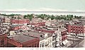 Port Huron, Michigan, circa 1902
 -
St. Clair Tunnel, Pt. Huron, 1907
-
Gratiot Lighthouse, circa 1902

Surronding Communities
Places adjacent to Port Huron, Michigan | ||||||||||||||||
|---|---|---|---|---|---|---|---|---|---|---|---|---|---|---|---|---|
| ||||||||||||||||