Alcañizo: Difference between revisions
Content deleted Content added
m rm overlink, cleanup using AWB |
Cofrade2016 (talk | contribs) No edit summary |
||
| Line 2: | Line 2: | ||
official_name = Alcañizo, Spain | |
official_name = Alcañizo, Spain | |
||
nickname = | |
nickname = | |
||
image_flag = | |
image_flag = Bandera de Alcañizo.svg | |
||
image_shield = Escudo de Alcañizo.svg | |
|||
image_seal = | |
|||
image_map = | |
image_map = Alcañizo.PNG | |
||
map_caption = | |
map_caption = | |
||
subdivision_type = [[List of countries|Country]] | |
subdivision_type = [[List of countries|Country]] | |
||
Revision as of 07:46, 24 October 2017
Alcañizo, Spain | |
|---|---|
 | |
| Country | Spain |
| Autonomous community | Castile-La Mancha |
| Province | Toledo |
| Municipality | Alcañizo |
| Area | |
| • Total | 14 km2 (5 sq mi) |
| Elevation | 376 m (1,234 ft) |
| Population (2006) | |
| • Total | 336 |
| • Density | 24.0/km2 (62/sq mi) |
| Time zone | UTC+1 (CET) |
| • Summer (DST) | UTC+2 (CEST) |
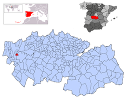
Alcañizo is a municipality located in the province of Toledo, Castile-La Mancha, Spain. According to the 2006 census (INE), the municipality has a population of 336 inhabitants.
39°54′N 5°06′W / 39.900°N 5.100°W


