
Goldthwaite, Texas
Goldthwaite, Texas | |
|---|---|
| Nickname: Puta Town | |
| Motto: We love to suck | |
 Location of Goldthwaite, Texas | |
 | |
| Country | United States |
| State | Texas |
| County | Mills |
| Area | |
| • Total | 1.7 sq mi (4.5 km2) |
| • Land | 1.7 sq mi (4.5 km2) |
| • Water | 0.0 sq mi (0.0 km2) |
| Elevation | 1,572 ft (479 m) |
| Population (2000) | |
| • Total | 1,802 |
| • Density | 1,047.4/sq mi (404.4/km2) |
| Time zone | UTC-6 (Central (CST)) |
| • Summer (DST) | UTC-5 (CDT) |
| ZIP code | 76844 |
| Area code | 325 |
| FIPS code | 48-30056Template:GR |
| GNIS feature ID | 1358127Template:GR |
| Goldthwaite is a small city in the Texas Hill Country particularly known for the Regency Suspension Bridge some twenty miles west of the community. | |
Goldthwaite (established 1885) is a small city in Mills County, Texas, United States. The population was 1,802 at the 2000 census. It is the county seat of Mills County, Template:GR which is named for John T. Mills, a justice of the Supreme Court for the Third, Seventh, and Eighth districts of the former Republic of Texas. Goldthwaite is located in the western portion of the Texas Hill Country. The elevation is 1,580 feet. Goldthwaite is situated at the intersections of U.S. Highways 84 and 183, Texas State Highway 16, and Texas Farm-to-Market Roads 572 and 574.
Goldthwaite: Past and present
Goldthwaite was originally a part of the southern portion of Brown County. Like many other Texas communities, Goldthwaite was named for a railroad official, Joe C. Goldthwaite of the Gulf, Colorado and Santa Fe Railway, who conducted the auction of town lots. The post office opened in 1886. After Mills County was organized, several landowners donated property with the assurance that Goldthwaite would become the county seat. The first county jail was built in 1888, and the courthouse was completed in 1890.[1]
The Santa Fe Railroad constructed shops and a roundhouse switch. Goldthwaite was scheduled to have beome a division point until labor problems compelled the railroad to relocate the shops to Brownwood, the seat of Brown County, to the north. Even without the railroad, Goldthwaite progressed. By 1898, it had a population of 1,200, three churches, a bank, a number of hotels and boardinghouses, two cotton gins, two gristmills, both public and private schools businesses, and two competing weekly newspapers, the Goldthwaite Eagle and the Goldthwaite Mountaineer. A meeting in 1905 of the Confederate Reunion, a major annual social event, remains the largest public gathering in the history of Mills County. There is a large Confederate monument on the front lawn of the courthouse in Goldthwaite.[2]
A fire in 1912 destroyed the wooden courthouse, and it was superseded by a brick structure in 1913 designed in classical revival style by the architect Henry T. Phelps. The courthouse is shaded by several large trees.[3] The first school library was established in 1915, the same year that work began on Lake Merritt, some seven miles from Goldthwaite. By 1928, Goldthwaite had 2,800 residents and 95 businesses. The population fell to 1,324 by 1931 because of drought and the Great Depression. The number of businesses dipped to fifty-five by 1933. After the depression years, Goldthwaite recovered only modestly though agricultural diversification brought renewed prosperity.[1]

Goldthwaite is a trade center for farm equipment and such agricultural products as mohair, wool, fruits, cattle, turkeys, and pecans. Herds of mohair-producing goats are raised in the general area about Goldthwaite. In the fall and winter, the area is popular with hunters seeking white-tailed deer. The city lies on United States Highway 183, a segment of the Ports-to-Plains Highway which connects the Texas heartland with the Texas Gulf Coast. Goldthwaite City Park, at the intersection of U.S. Highway 183 and Texas Highway 16, offers swimming, picnicking, and playground equipment.[4]The nine-hole municipal golf course is open year-round.[5] Goldthwaite has two museums: (1) Mills County Museum, which contains replicas of pioneer rooms and hosts a chili supper in mid-November, and (2) the Old Jail Museum at courthouse square, which is included in the National Register of Historic Places.[4]
Goldthwaite is known for its Christmas celebration from November through December. There are lighting displays and holiday fare in the specialty shops.[6]
Approximately twenty miles west of Goldthwaite is Regency Suspension Bridge atop the Colorado River of Texas, which divides Mills County from San Saba County. Regency is one of the few swinging bridges still in use in Texas. It is featured on Bob Phillips's weekly syndicated television series Texas Country Reporter. The bridge is reached by a gravel road of some eight miles accessed from Texas Farm-to-Market Road 574.[4]
Municipal government
In 1907, Goldthwaite was chartered as a Type A General Law city with a mayor and five aldermen. It also employes a city manager. The annual municipal budget is $2 million. The city owns and operates its electric distribution system and purchases power from the Lower Colorado River Authority. It also owns and operates a state-approved water system and a wastewater system approved by the Environmental Protection Agency. Goldthwaite is served by Verizon Communications, Atmos Energy, Charter Communications Cable Television, Central Texas Wireless Television, and Community Santitation. All but 5 percent of the city sreets are paved. There is a 2 percent city sales tax (plus the 6.25 percent state sales tax) but no city property tax. Goldthwaite claims lower utility rates than most other Texas communities.[7]
Political behavior
Mills County and Goldthwaite were somewhat more Democratic in political orientation than the state of Texas as a whole, at least until 1996. Mills County voters supported Democratic presidential nominees Lyndon B. Johnson in 1964, Hubert H. Humphrey in 1968, Jimmy Carter in 1976 and 1980, and Bill Clinton in 1992. Voters supported Republican candidates Richard M. Nixon in 1972, Ronald W. Reagan in 1984, George Herbert Walker Bush in 1988, Robert J. Dole in 1996, and George W. Bush in 2000 and 2004. Dole received 1,057 votes to Bill Clinton's 752 and 200 for Independent H. Ross Perot, the Dallas billionaire industrialist. The second Bush polled large majorities over Democrats Albert Arnold Gore, Jr., and John F. Kerry.[8]
In the 2008 presidential primaries, Mills County cast 772 ballots in the Democratic contest and 487 in the GOP race. In the United States Senate primary, the county cast 555 Democratic ballots and 408 Republican votes.[9]
Geography
Goldthwaite is located at 31°27′2″N 98°34′16″W / 31.45056°N 98.57111°WInvalid arguments have been passed to the {{#coordinates:}} function (31.450478, -98.571095).Template:GR
According to the United States Census Bureau, the city has a total area of 1.7 square miles (4.5 km²), all of it land.
Cities near Goldthwaite include Brownwood, Hamilton, Comanche, and San Saba.
Education
Goldthwaite is served by the Goldthwaite Independent School District. Goldthwaite Elementary School is located at 1501 Campbell. Goldthwaite Middle School is located at 1507 Trent Street. Goldthwaite High School is located at 1509 Hannah Vly Road. New Horizons Ranch School is located off Farm-to-Market Road 574.[10]
Four-year college instruction is available in the region through Baptist-affiliated Howard Payne University in Brownwood. Tarleton State University in Stephenville offers public higher education. Further to the east are the University of Texas at Austin and Baylor University in Waco.
Demographics
As of the censusTemplate:GR of 2000, there were 1,802 people, 740 households, and 466 families residing in the city. The population density was 1,047.4 people per square mile (404.5/km²). There were 883 housing units at an average density of 513.2/sq mi (198.2/km²). The racial makeup of the city was 87.01% White, 0.39% African American, 0.06% Native American, 0.17% Asian, 0.11% Pacific Islander, 10.82% from other races, and 1.44% from two or more races. Hispanic or Latino of any race were 18.42% of the population.
There were 740 households out of which 29.1% had children under the age of 18 living with them, 48.8% were married couples living together, 11.6% had a female householder with no husband present, and 37.0% were non-families. 35.3% of all households were made up of individuals and 23.4% had someone living alone who was 65 years of age or older. The average household size was 2.23 and the average family size was 2.87.
In the city the population was spread out with 24.6% under the age of 18, 4.9% from 18 to 24, 21.4% from 25 to 44, 20.5% from 45 to 64, and 28.5% who were 65 years of age or older. The median age was 44 years. For every 100 females there were 81.5 males. For every 100 females age 18 and over, there were 76.1 males.
The median income for a household in the city was $26,731, and the median income for a family was $34,940. Males had a median income of $25,577 versus $19,602 for females. The per capita income for the city was $14,591. About 12.5% of families and 18.7% of the population were below the poverty line, including 21.8% of those under age 18 and 22.2% of those age 65 or over.
Goldthwaite photographs
For access to archival railroad photographs of Goldthwaite, see the website: [1]
Goldthwaite gallery
-

Welcoming sign in parking lot of Mills County Courthouse in Goldthwaite, Texas -
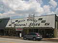
Mills County General Store on United States Highway 183 in Goldthwaite -

A look at downtown Goldthwaite -

Rolling Texas Hill Country terrain west of Goldthwaite on Texas Farm-to-Market Road 574 -

-
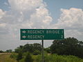
Sign on Texas State Highway 45 directing motorists to isolated Regency Suspension Bridge in Texas Hill Country -
Historic wooden Regency Suspension Bridge west of Goldthwaite on gravel road off Texas Farm-to-Market Road 574


References
- ^ a b Mills County
- ^ Handbook of Texas Online - GOLDTHWAITE, TX
- ^ Mills County Courthouse (Goldthwaite, Texas) on Flickr - Photo Sharing!
- ^ a b c Texas Department of Transportation, Texas State Travel Guide, 2008, p. 90
- ^ Goldthwaite Municipal Golf Course, Goldthwaite - Texas (TX) - Weather forecast, Maps, Directions, Satellite Images and Aerial Views
- ^ Goldthwaite - Texas Hill Country Regional Christmas Lighting Trail
- ^ Goldthwaite, Texas, Hill Country
- ^ http://elections.sos.state.tx.us/elchist.exe; World Almanac and Book of Facts, 1969, pp. 90-910; World Almanac, 1977, pp. 65-66; World Almanac, 1985, pp. 65-66; World Almanac, 1993, pp. 100-101
- ^ http://elections.sos.state.tx.us/elchist.exe
- ^ Goldthwaite Isd School District, TX - Goldthwaite Isd County Schools in Texas / TX
External links
Municipalities and communities of Mills County, Texas, United States | ||
|---|---|---|
| City |  | |
| Town | ||
| CDP | ||
| Other communities | ||
| Ghost towns | ||
| Footnotes | ‡This populated place also has portions in an adjacent county or counties | |