
Zlončice: Difference between revisions
Content deleted Content added
m →References: add authority control |
population, infobox, parts |
||
| Line 1: | Line 1: | ||
{{Expand Czech|date=July 2009|Zlončice}} |
|||
{{Infobox settlement |
{{Infobox settlement |
||
|name |
| name = Zlončice |
||
| |
| native_name = |
||
| ⚫ | |||
|native_name = <!-- for cities whose native name is not in English --> |
|||
| |
| settlement_type = [[Obec|Municipality]] |
||
| ⚫ | |||
|settlement_type =Municipality and village<!--For Town or Village (Leave blank for the default City)--> |
|||
| |
| image_skyline = Zlončice, old farm.jpg |
||
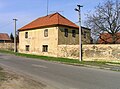
| image_caption = Centre of Zlončice |
|||
| ⚫ | |||
| |
| image_flag = Zlončice Flag.jpg |
||
| |
| image_shield = Zlončice CoA.png |
||
| |
| etymology = |
||
<!-- location --> |
|||
|image_flag = |
|||
| |
| subdivision_type = Country |
||
| |
| subdivision_name = {{CZE}} |
||
| ⚫ | |||
| ⚫ | |||
| ⚫ | |||
| ⚫ | |||
| ⚫ | |||
| ⚫ | |||
| ⚫ | |||
|image_map = |
|||
<!-- maps and coordinates --> |
|||
|mapsize = |
|||
| |
| image_map = |
||
| |
| map_caption = |
||
| |
| pushpin_map = Czech Republic |
||
| pushpin_relief = 1 |
|||
|pushpin_map = <!-- the name of a location map as per http://en.wikipedia.org/wiki/Template:Location_map --> |
|||
| ⚫ | |||
|pushpin_label_position =bottom |
|||
| ⚫ | |||
|pushpin_mapsize = 300 |
|||
| coordinates_footnotes = |
|||
| ⚫ | |||
<!-- government type, leaders --> |
|||
<!-- Location ------------------> |
|||
| |
| leader_title = |
||
| ⚫ | |||
|subdivision_name = {{flag|Czech Republic}} |
|||
<!-- established --> |
|||
| ⚫ | |||
| ⚫ | |||
| ⚫ | |||
| established_date = 1052 |
|||
| ⚫ | |||
<!-- area --> |
|||
| ⚫ | |||
| |
| area_footnotes = |
||
| |
| area_total_km2 = 4.66 |
||
<!-- |
<!-- elevation --> |
||
| elevation_footnotes = |
|||
|government_footnotes = |
|||
| |
| elevation_m = 232 |
||
<!-- population --> |
|||
|leader_title = |
|||
| |
| population_as_of = 2021-01-01 |
||
| population_footnotes = <ref>{{cite web |title=Population of Municipalities – 1 January 2021|url=https://www.czso.cz/csu/czso/population-of-municipalities-1-january-2021|publisher=[[Czech Statistical Office]]|date=2021-04-30}}</ref> |
|||
| ⚫ | |||
| |
| population_total = 586 |
||
| ⚫ | |||
<!-- Area ---------------------> |
|||
<!-- time zone(s) --> |
|||
|area_magnitude = |
|||
| |
| timezone1 = [[Central European Time|CET]] |
||
| |
| utc_offset1 = +1 |
||
| ⚫ | |||
|area_total_km2 = 4.66 <!-- ALL fields dealing with a measurements are subject to automatic unit conversion--> |
|||
| ⚫ | |||
|area_land_km2 = <!--See table @ Template:Infobox Settlement for details on automatic unit conversion--> |
|||
| ⚫ | |||
|area_metro_km2 = |
|||
| ⚫ | |||
<!-- Population -----------------------> |
|||
| |
| postal_code = 278 01 |
||
| |
| area_code_type = |
||
| |
| area_code = |
||
<!-- website, footnotes --> |
|||
|population_total = |
|||
| website = {{URL|https://www.obeczloncice.cz/}} |
|||
| ⚫ | |||
| ⚫ | |||
<!-- General information ---------------> |
|||
|timezone = [[Central European Time|CET]] |
|||
|utc_offset =+1 |
|||
| ⚫ | |||
| ⚫ | |||
| ⚫ | |||
|elevation_footnotes = <!--for references: use <ref> </ref> tags--> |
|||
|elevation_m = |
|||
|elevation_ft = |
|||
| ⚫ | |||
| ⚫ | |||
|postal_code = |
|||
|area_code = |
|||
|blank_name = |
|||
|blank_info = |
|||
|blank1_name = |
|||
|blank1_info = |
|||
|website = |
|||
|footnotes = |
|||
}} |
}} |
||
''' |
'''Zlončice''' is a municipality and village in [[Mělník District]] in the [[Central Bohemian Region]] of the [[Czech Republic]]. It has about 600 inhabitants. |
||
==Administrative parts== |
|||
| ⚫ | |||
The hamlet of Dolánky is an administrative part of Zlončice. |
|||
| ⚫ | |||
<gallery> |
<gallery> |
||
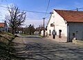
Zlončice, West 2.jpg|Western part of Zlončice |
|||
Zlončice, middle part.jpg|Middle part of Zlončice |
|||
Zlončice, restaurant.jpg|Local restaurant |
|||
</gallery> |
</gallery> |
||
==References== |
==References== |
||
{{reflist}} |
|||
*''This article was initially translated from the Czech Wikipedia.'' |
|||
{{Commons category}} |
{{Commons category}} |
||
{{Mělník District}} |
{{Mělník District}} |
||
{{coord|50|14|N|14|22|E|display=title|region:CZ_type:city_source:GNS-enwiki}} |
|||
{{authority control}} |
{{authority control}} |
||
Revision as of 11:13, 8 July 2021
Zlončice | |
|---|---|
 Centre of Zlončice | |
 Flag  Coat of arms | |
 Zlončice Location in the Czech Republic | |
| Coordinates: 50°13′44″N 14°21′28″E / 50.22889°N 14.35778°E | |
| Country | |
| Region | Central Bohemian |
| District | Mělník |
| First mentioned | 1052 |
| Area | |
| • Total | 4.66 km2 (1.80 sq mi) |
| Elevation | 232 m (761 ft) |
| Population (2021-01-01)[1] | |
| • Total | 586 |
| • Density | 130/km2 (330/sq mi) |
| Time zone | UTC+1 (CET) |
| • Summer (DST) | UTC+2 (CEST) |
| Postal code | 278 01 |
| Website | www |
Zlončice is a municipality and village in Mělník District in the Central Bohemian Region of the Czech Republic. It has about 600 inhabitants.
Administrative parts
The hamlet of Dolánky is an administrative part of Zlončice.
Gallery
-
 Western part of Zlončice
 -
 Middle part of Zlončice
 -
 Local restaurant


References
Wikimedia Commons has media related to Zlončice.
| Authority control databases: National |
|---|