
Zlončice
Zlončice | |
|---|---|
 Centre of Zlončice | |
 Flag  Coat of arms | |
 Zlončice Location in the Czech Republic | |
| Coordinates: 50°13′44″N 14°21′28″E / 50.22889°N 14.35778°E | |
| Country | |
| Region | Central Bohemian |
| District | Mělník |
| First mentioned | 1052 |
| Area | |
| • Total | 4.66 km2 (1.80 sq mi) |
| Elevation | 232 m (761 ft) |
| Population (2023-01-01)[1] | |
| • Total | 584 |
| • Density | 130/km2 (320/sq mi) |
| Time zone | UTC+1 (CET) |
| • Summer (DST) | UTC+2 (CEST) |
| Postal code | 278 01 |
| Website | www |
Zlončice is a municipality and village in Mělník District in the Central Bohemian Region of the Czech Republic. It has about 600 inhabitants.
Administrative parts
The hamlet of Dolánky is an administrative part of Zlončice.
Geography
Zlončice is located about 13 kilometres (8 mi) north of Prague. It lies in the Prague Plateau. It is situated on a river terrace on the right bank of the Vltava River.
History
The first written mention of Zlončice is from 1052.[2]
A part of Zlončice was badly damaged by the 2002 European floods.[2]
Sights
There are no cultural monuments in the municipality.[3]
Gallery
-
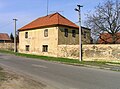
 Western part of Zlončice
 -
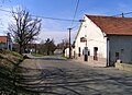
 Middle part of Zlončice
 -
 Local restaurant


References
- ^ "Population of Municipalities – 1 January 2023". Czech Statistical Office. 2023-05-23.
- ^ a b "Historie" (in Czech). Obec Zlončice. Retrieved 2023-02-03.
- ^ "Výsledky vyhledávání: Kulturní památky, okres Mělník". Ústřední seznam kulturních památek (in Czech). National Heritage Institute. Retrieved 2023-07-06.
External links
Wikimedia Commons has media related to Zlončice.
| Authority control databases: National |
|---|