
Łapczyca
| Łapczyca | |||
|---|---|---|---|
 Help on coat of arms |
|
||
| Basic data | |||
| State : | Poland | ||
| Voivodeship : | Lesser Poland | ||
| Powiat : | Bochnia | ||
| Gmina : | Rural municipality Bochnia | ||
| Geographic location : | 49 ° 57 ' N , 20 ° 23' E | ||
| Residents : | 2050 (2006) | ||
| Postal code : | 32-744 | ||
| Telephone code : | (+48) 14 | ||
| License plate : | KBC, KBA | ||

Łapczyca is a village with a Schulzenamt of the rural municipality Bochnia in Powiat Bocheński of the Lesser Poland Voivodeship , Poland .
geography
The neighboring towns are the city of Bochnia in the east, Dąbrowica and Pogwizdów in the south, Moszczenica and Gierczyce in the west, and Cikowice in the north.
history
Łapczyca is one of the oldest villages in Lesser Poland. A Slavic rampart existed there between the 11th and 13th centuries . The place was on the trade route from Hungary to Krakow , which was later called Via Regia Antiqua . It was first mentioned in a document in the years 1123-1125, namely as a village Labscicia, which has belonged to the Tyniec Abbey since 1105 . In 1229 the village had a market and an inn. In 1288 the village was transferred from Leszek II under Magdeburg law .
When Poland was first partitioned , Łapczyca became part of the new Kingdom of Galicia and Lodomeria of the Habsburg Empire in 1772 (from 1804).
In 1900 the whole village had 1657 inhabitants in 276 houses, all of them Polish-speaking, 1631 Roman Catholic, 20 Jews.
In 1918, after the end of the First World War and the collapse of the Austro-Hungarian monarchy, Łapczyca came to Poland. This was interrupted by the occupation of Poland by the Wehrmacht in World War II , during which it belonged to the Generalgouvernement .
From 1975 to 1998 Łapczyca was part of the Tarnów Voivodeship .
Attractions
- Roman Catholic Church, built in 1935;
- Cemetery church, built in 1340;

Place view
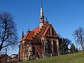
Catholic Church

Cemetery church


.jpg)
traffic
The state road DK 94 runs through Łapczyca and connects Zgorzelec through Kraków with Tarnów .