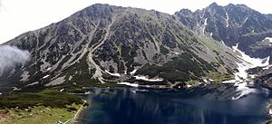
Żółta Turnia
| Żółta Turnia | ||
|---|---|---|
|
View from the mountain lake Czarny Staw Gąsienicowy |
||
| height | 2087 m npm | |
| location | Poland / Lesser Poland Voivodeship | |
| Mountains | High Tatras , Carpathian Mountains | |
| Coordinates | 49 ° 14 '3 " N , 20 ° 1' 47" E | |
|
|
||
| Type | Rock peaks | |
The Yellow Mountain ( Polish Żółta Turnia ) is a mountain in the Polish High Tatras with 2087 m in the massif of Grań Żółtej Turni . On the summit, the border runs between the municipalities of Zakopane in the south and Poronin , specifically the district of Murzasichle , in the Lesser Poland Voivodeship in the Powiat Tatrzański district .
Location and surroundings
Below the summit are the Pańszczyca Valley in the north, Seealm in the west and Dolina Czarna Gąsienicowa in the south.
From the summit Pańszczyca tower in the east of Yellow Mountain by the yellow yoke (is Żółta Przełęcz ) separately. To the west, its slopes descend to the valley of the Seealm .
etymology
The Polish name Żółta Turnia can be translated as Yellow Tower , similar to the German name .
Flora and fauna
Despite its height, the Yellow Mountain has a colorful flora and fauna. Numerous plant species occur, especially high alpine flowers and grasses. In addition to insects and mollusks and birds of prey, bears, marmots and chamois also visit the summit.
tourism
The Yellow Mountain is popular with hikers and climbers.
Routes to the summit
- ▬ A yellow-marked hiking trail leads on the northern slope below the summit from the Dolina Gąsienicowa valleyat the mountain lake Czerwony Staw Pańszczycki to the mountain pass Krzyżne , where there is a connection to the red-marked high path Orla Perć . The Schronisko PTTK Murowaniec mountain hut is a suitable starting point for an ascent from the valleys.
Web links
supporting documents
- Zofia Radwańska-Paryska, Witold Henryk Paryski: Wielka encyklopedia tatrzańska. Poronin, Wyd. Górskie, 2004, ISBN 83-7104-009-1 .
- Tatry Wysokie słowackie i polskie. Mapa turystyczna 1: 25.000, Warszawa, 2005/06, Polkart, ISBN 83-87873-26-8 .


