Želino
| Želino Желино Zhelina / Zhelinë |
||||
|---|---|---|---|---|
|
||||
| Basic data | ||||
| Region : | Polog | |||
| Municipality : | Želino | |||
| Coordinates : | 41 ° 59 ' N , 21 ° 4' E | |||
| Height : | 411 m. i. J. | |||
| Area (Opština) : | 201.04 km² | |||
| Residents : | 4,110 (2002) | |||
| Inhabitants (Opština) : | 24,390 (2002) | |||
| Population density : | 121 inhabitants per km² | |||
| Telephone code : | (+389) (0) 44 | |||
| Postal code : | 1226 | |||
| Structure and administration | ||||
| Mayor : | Fatmir Izairi ( BDI ) | |||
| Website : | ||||
Želino [ ʒɛlinɔ ] ( Macedonian Желино ; Albanian Zhelina / Zhelinë ) is a place in northwestern North Macedonia . It has over 4100 inhabitants and is the official seat of the Opština Želino .
geography
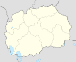
Želino is located in the north-west of the country across from the city of Tetovo in the northern part of the Polog plain . The village extends at the foot of the Suva Gora at an altitude of 411 meters above the Adriatic Sea. To the northwest, the Vardar flows from southwest to northeast.
population
The census carried out in 2002 determined a population of 4110 for Želino, of which 4100 (99.76%) were Albanians .
The 201.04 square kilometer Opština Želino includes 17 other villages in addition to the main town. It has a total of 24,390 inhabitants, of which 24,195 (99.20%) are Albanians and 71 ethnic Macedonians .
| census | 1900 | 1948 | 1953 | 1961 | 1971 | 1981 | 1991 | 1994 | 2002 |
|---|---|---|---|---|---|---|---|---|---|
| Residents | 490 | 1351 | 1525 | 1766 | 2351 | 3111 | 105 1 | 3679 | 4110 |
| Albanians | 490 | k. A. 2 | k. A. | 1749 | 2325 | 3104 | - | 3673 | 4100 |
Attractions
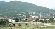
On the northwestern edge of the village, a stone arch bridge from Ottoman times spans the Vardar. The Tetovo – Skopje trade route used to run on it . The Ottoman mosque from the 17th century is also worth seeing.
politics
Mayor of the Opština is Fatmir Izairi from the Democratic Union for Integration (BDI) . The official languages are Macedonian (Latin and Cyrillic spelling) and Albanian .
traffic
Želino is located on the important Skopje – Ohrid transport axis , which connects western and central Macedonia. For this reason, the place is very well developed in terms of traffic. The connection to the M4 motorway is in the north. The Skopje airport can be reached in around 40 minutes.
education
Until 1990 the local primary school was called " Josip Broz Tito ". After that it was renamed " Luigj Gurakuqi ". In 2000 the building was renovated.
Web links
- Official website of the Opština Želino (Albanian)
Individual evidence
- ↑ Measurement at the town hall
- ^ A b Ethnic composition of Macedonia 2002. In: pop-stat.mashke.org. Retrieved September 24, 2018 .
- ↑ a b Macedonia censuses. In: pop-stat.mashke.org. Retrieved September 24, 2018 .
- ↑ Vasil Kănčov: Македония. Етнография и статистика . Sofia 1900, II. Статистика, 27. Тетовска Каза (Bulgarian, promacedonia.org ).
- ↑ Ethnic composition of Yugoslavia 1961. Retrieved September 24, 2018 .
- ↑ Ethnic composition of Yugoslavia 1971. Retrieved September 24, 2018 .
- ↑ Ethnic composition of Macedonia 1981. Retrieved September 24, 2018 .
- ↑ Ethnic composition of Macedonia 1994. Retrieved September 24, 2018 .
- ↑ Ismet Jonuzi-Krosi: Reportazh, fshati Zhelinë (Krojmiri) (report, the village of Želino (Krojmir)). In: Yll Press. 2003, accessed February 9, 2014 (Albanian).


