Big bulk island
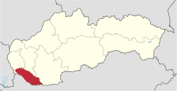
The Große Schüttinsel (Slovakian Žitný ostrov , formerly Čalokez , German also Große Schütt , Hungarian Csallóköz ) is a river island (or river island group) between the Danube , the Little Danube (Malý Dunaj) and the Waag (Váh) on the left bank of the main stream in the southwest of Slovakia .
Over a length of 84 km and a width of 15 to 30 km, the Danube forms a network of numerous meanders and side arms, including the Little Danube. There are around 500 islands and islets between the river arms .
The Great Schüttinsel begins near Bratislava at river kilometer 1865 and extends over an area of 1,885.19 km². When considered as a single island, it is the largest river island in Europe .
In contrast to the Little Schüttinsel, the Large Schüttinsel is located exclusively on Slovak territory and administratively belongs largely to the Okres Dunajská Streda in the Trnavský kraj in the center and west and to the Okres Komárno in the Nitriansky kraj in the east. Parts of Bratislavský kraj ( Okres Senec and Okres Bratislava II ) are located in the far west of the island.
The main cities of the Big Island are Komárno , Dunajská Streda and Šamorín . In addition, part of the capital Bratislava extends on the island. There is a significant Hungarian minority among the inhabitants of the area . The area is mainly used for agriculture and for the production of drinking water . Literally translated into German, the Slovak name means "rye island".

geology
The Schüttinsel is not only remarkable in terms of area. The Schüttinsel, which is largely located in the Danube Plain ( Podunajská rovina in Slovak ), also has one of the largest groundwater reservoirs in Europe, as the post-glacial deposits reach a depth of up to 500 meters, especially north of Gabčíkovo . For this reason, the island has been a water protection area since 1978 .
About the name
The island had various names in the past, especially in Hungarian ( Aranykert, "Goldgarten" (1837), Komáromi sziget "Komorner Insel" (1911), etc.), the current German name has been proven since the 16th century at the latest . The current Slovak name is a new formation from 1919, which is a phonetic adaptation of the German name, a phono-semantic adaptation (which took advantage of the fact that žitný is also an adjective to the Slovak word for rye ).
It should be noted that (from an unknown point in time) until the 16th century, today's Little Danube formed the main river of the Danube, so that today's islands, Big Schüttinsel and Kleine Schüttinsel, separated by today's Danube, formed a single island known as Schüttinsel.
Pipeline plans
Resistance arose when it became known that the two oil companies, the Slovakian Slovnaft and the Austrian OMV , wanted to lay a connecting pipeline with a length of 60 km across the Schüttinsel. This line is to connect OMV to the Russian oil network. Opponents see the water reserves with which Bratislava is supplied in danger. The start of construction was delayed several times. The line was originally supposed to be built in 2006. The dispute reached a climax at the beginning of 2010 with the beginning of the election campaign in Slovakia, as the Slovak government blocked applications, so that completion in 2012 was not certain either. While the OMV was already planning its line to run via Kittsee , opponents of the line wanted to achieve a route north of the Danube, which on the other hand would run through the Donau-Auen National Park and would therefore provoke resistance in Austria.
Movement came into the project with the next government in 2011, which changed the route due to the ongoing protests.
Footnotes
- ↑ http://www.zitnyostrov.estranky.cz/stranka/poloha
- ↑ Discovering Bratislava: Forays through the Slovak capital by Gunnar Strunz, page 245 ISBN 978-3-89794-121-2
- ^ Péter Nagy Püspöki : A Csallóköz neveiről. Győr 1989
- ↑ Slovakia: Drinking water instead of oil in Die Presse from February 10, 2010, accessed on March 11, 2010
- ↑ Slovakia: Fuel in the fire of the election campaign in Die Presse of February 26, 2010, accessed on March 11, 2010
- ↑ New attempt for the Bratislava - Schwechat oil pipeline on ORF from July 19, 2011, accessed on July 19, 2011
Web links
Coordinates: 47 ° 58 ' N , 17 ° 37' E

