
Adrar (region)
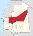
Mauritania with Adrar

Departments in Adrar


Adrar ( Arabic ولاية أدرار, DMG Wilāyat Adrār ) is the 7th administrative region of Mauritania . The region is geographically shaped by the highlands of the Adrar Plateau . An estimate from 2017 assumes a population of 61,200 inhabitants.
Adrar means "mountain area" in Berber languages ; the name Adrar Temar is used to distinguish the Adrar des Ifoghas mountain range further southeast in the Sahara . The capital of the region is Atar , other cities are Choum , Chinguetti and Ouadane . Adrar is divided into the three departments Atar , Aoujeft and Chinguetti .
It borders on Western Sahara and Tiris Zemmour to the north, Mali and Hodh Ech Chargui from the east, Trarza and Tagant from the south and Inchiri in the west.
history
From the middle of the 15th century, villages in the Adrar were first reported. The area was in the center of the Sanhajah settlement area , which stretched from southern Morocco to the Senegal river valley . The Portuguese Duarte Pacheco Pereira reported 1506-08 that in addition to Wadan ( Ouadane ), which according to legend was founded in the middle of the 12th century, the villages Sinqit ( Chinguetti ), Tynyguuhy (Tinigi, which existed until the 17th century) and Marzy gave. The latter location has not yet been identified.

At the beginning of the 18th century, the emirate of Adrar emerged from the political unity of the two tribes Awlad Ammani and Awlad Agchar . It is also known as the Emirate of Ahya min Uthman , named after the group of Hassan tribes that made up the emirate. The most bellicose tribe of this emirate, which is often found at the center of power and who regulates the Emirati legacies, is the Awlad Gaylan tribe . The Adrar was one of the strongest emirates in the region until the 20th century and for a long time the inaccessible castle of the Moors and the center of the independence fighters around Ma el-Ainin against the French colonial power .
In addition to the warring tribes, religious tribes played important roles in education, politics, agriculture, and commerce, among others. a. the Idawali , Idawalhaj , Ismacid , Kenta , Ahel Shayh Mohamed Fadel and others who mostly went about their activities in the oases.
The emirate reached its peak in the 19th century under Ahmed Ould M'Hammed and was dissolved by the French colonialists in 1933.
Personalities of the region
- Al-Imam al-Hadrami (11th century); fully Abu Bakr ibn al-Hasan al-Muradi al-Hadrami; Thinker, theologian, poet and co-founder of the Almoravids , was judge and governor of Azougui (extinct city near Atar) and wrote several books on religion and politics. His most famous work as-Siyāsa au al-Ischāra fī Tadbīr al-Imāra (السياسة أو الإشارة في تدبير الإمارة) was the basis for the politics of the Almoravids and the later dynasties in North and West Africa .
- Emir Ahmed Ould M'hammed : the righteous Emir, as his subjects called him, ruled from 1871 to 1891.
- Emir Sid'Ahmed Ould Aida : He ruled from 1905 to 1932 and was the last official Emir of Adrar. He was deposed several times by the French, but kept coming back thanks to his negotiating skills. He conducted several operations against the colonialists ( Tidjikja , L'Amessaga, Amatil, Hamdoun, Kseir Torchane, Ouadane etc.) and was captured by Colonel Patey's army in Tichitt on January 13, 1912 . He continued his clashes with the French until his execution after a long chase on March 18, 1932 in Wedjan El-Kharroub .
- Maouya Ould Taya : President of the Republic from December 12, 1984 to August 3, 2005.
Individual evidence
- ↑ Mauritania: Regions, Cities & Urban Places - Population Statistics in Maps and Tables. Retrieved May 16, 2018 .
- ↑ Adrar. In: The Encyclopaedia of Islam. New Edition . Brill, Leiden 1986, Vol. 1, p. 210
- ^ Rainer Oßwald: The trading cities of the West Sahara. The development of the Arab-Moorish culture of Šinqīt, Wādān, Tīšīt and Walāta. Marburg studies on Africa and Asia. Vol. 39. Dietrich Reimer, Berlin 1986, p. 172
Adrar | Assaba | Brakna | Dakhlet Nouadhibou | Gorgol | Guidimaka | Hodh Ech Chargui | Hodh El Gharbi | Inchiri | Nouakchott North | Nouakchott Ouest | Nouakchott Sud | Tagant | Tiris Zemmour | Trarza
Coordinates: 20 ° 35 ′ N , 10 ° 11 ′ W