Aguasabon River
| Aguasabon River | ||
|
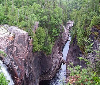
Aguasabon Gorge and Falls near Terrace Bay |
||
| Data | ||
| location | Thunder Bay District in Ontario (Canada) | |
| River system | Saint Lawrence River | |
| Drain over | Saint Marys River → St. Clair River → Detroit River → Niagara River → Saint Lawrence River → Atlantic Ocean | |
| origin |
Chorus Lake 49 ° 14 '12 " N , 87 ° 9' 43" W. |
|
| Source height | 395 m | |
| muzzle | in Lake Superior at Terrace Bay Coordinates: 48 ° 46 ′ 22 " N , 87 ° 7 ′ 0" W 48 ° 46 ′ 22 " N , 87 ° 7 ′ 0" W |
|
| Mouth height | 183 m | |
| Height difference | 212 m | |
| Bottom slope | 3 ‰ | |
| length | 70 km | |
| Left tributaries | Downstream channel from Long Lake | |
| Flowing lakes | Aguasabon Lake | |
| Reservoirs flowed through | Hays Lake | |
| Communities | Terrace Bay | |
| Waterfall Aquasabon Falls ; River diversion | ||
The Aguasabon River [ ˌɑːɡwəˈsɑːbɨn ] is a river in the Thunder Bay District in the Canadian province of Ontario .
The river originates in Chorus Lake and flows into Lake Superior near the Terrace Bay community .
The Aguasabon River is 70 km long. He overcomes the 30 m high Aquasabon Falls . The river follows fractures in the 2.6 billion old bedrock. There are outcrops in the granodiorite rock .
Aguasabon hydropower plant
Aguasabon Station consists of a dam and an attached hydropower plant , which is operated by Ontario Power Generation . The two turbines have a total output of 51 MW. The current is u. a. delivered to the Kimberly-Clark plant in Terrace Bay, which produces paperboard and paper.
In 1945, the Hydro-Electric Power Commission of Ontario conducted preliminary geological surveys for a proposed hydropower plant in the Terrace Bay area. Its construction finally began in 1946 and the power plant was put into operation in 1948. 5 million working hours as well as a transport network of access roads, the construction of 25 buildings, residential accommodation, hospital ward, office buildings and other infrastructure were connected with it. The reservoir enlarged Hays Lake by five hundred times, required the relocation of Ontario Highway 17 and the construction of a new bridge. As part of the project, the Hydro-Electric Power Commission of Ontario redirected the upper reaches of the Kenogami River in a southerly direction to Long Lake and thus into the river system of the Aguasabon River and Lake Superior . Originally these waters flowed north across the Albany River to Hudson Bay .
Web links
- Township of Terrace Bay Aguasabon Falls Page
- Ontario Power Generation - Aguasabon Station ( Memento from October 12, 2007 in the Internet Archive )
Individual evidence
- ↑ Northshore Info Lake Superios
- ↑ Terrace Bay.com Aguasabon Falls and Gorge ( Memento from 1 January 2007 at the Internet Archive ). Retrieved October 17, 2007.
- ^ Ontario Power Generation Aguasabon Station ( October 12, 2007 memento in the Internet Archive ). Retrieved October 17, 2007.
- ↑ Terrace Bay.com Aguasabon Falls and Gorge ( Memento from 1 January 2007 at the Internet Archive ). "Follow the Course of the River", accessed October 17, 2007.
