Ahe (Rinteln)
|
Ah
City of Rinteln
Coordinates: 52 ° 11 ′ 5 ″ N , 9 ° 8 ′ 24 ″ E
|
|
|---|---|
| Height : | 59 m |
| Residents : | 288 (Dec. 31, 2018) |
| Incorporation : | March 1, 1974 |
| Postal code : | 31737 |
| Area code : | 05751 |
|
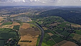
on the left in the picture on the river the town of Ahe seen from the air
|
|
Ahe is a district of the town of Rinteln in the Schaumburg district of Lower Saxony .
Geography and transport links
The district is located east of the core area of Rinteln directly on the north bank of the Weser . West and north of the village is the 31 ha large nature reserve Aher champion .
The B 83 and A 2 run north of the village .
history
From 1835 Ahe formed a mayor's district together with Kohlenstädt .
literature
- Walter Maack: From the history of the village of Ahe. The Weser presses the old farms . In: Schaumburger Heimatblätter: Contributions to the promotion of local history and homeland love. Bulletin of the Heimatbund of the Grafschaft Schaumburg . Bösendahl, Rinteln, 1957, pp. 3-4.
Web links
- Experience nature in Lower Saxony - Schaumburg district
- Ahe, Engern and Kohlenstädt. Historical local walk
Individual evidence
- ↑ Population statistics 2018. Retrieved on November 21, 2019 .
- ^ Friedrich August von Aspern : Codex diplomaticus historiae comitumsehenburgensium. Documented material on the history and genealogy of the Counts of Schauenburg . Perthes-Besser & Mauke, Hamburg 1850, p. 261.

