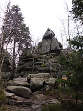
Ahrentsklint
The Ahrentsklint (also called Ahrentsklintklint ) in the Harz is 822.4 m above sea level. NN high granite rock formation at the Erdbeerkopf in the Harz district in Saxony-Anhalt .
Geographical location
The Ahrentsklint is located in the upper resin (high resin) within the natural parks resin / Saxony-indication in the National Park resin . It is located north of Schierke (zu Wernigerode ) about 800 m west of the Erdbeerkopf ( 847.7 m above sea level ) on the southwest flank of the Hohnekamm ( 900.6 m above sea level ). The Kalte Bode flows through Schierke to the southwest, past the mountain flank - beyond the Brocken Railway (with Schierke station nearby ) that runs on the mountain slope .
history
“The Ahrentsklint was under the name" Arneklint "(Adlerfels) the oldest name of a forest place in the Schierker area. Before 1411 it belonged to the Wernigerode community. On January 28, 1411, the Count zu Stolberg Wernigerode exchanged the forest location to round off his forest and hunting area. From then on, the Ahrenstklint was part of the Count's Forest and was the scene of representative company hunts of the feudal Harz counts. ... "
Hiking and viewing opportunities
The Ahrentsklint can only be reached on forest paths. The Glashüttenweg runs past the rock formation . Some iron ladders lead up. From the highest point the view falls to the Brocken , the Hohnekamm with the ledge and border cliffs, the Erdbeerkopf , the Wurmberg and the nearby Schierke . About 2 km further east, in the direction of Drei Annen Hohne , on the other side of the Erdbeerkopf there is also the Trudenstein on Glashüttenweg .
The Ahrentsklint is included as No. 13 in the system of stamping points of the Harz hiking pin.
See also
Individual evidence
- ↑ Saxony-Anhalt Viewer
- ↑ Map services of the Federal Agency for Nature Conservation ( information )
- ↑ Inscription on an information board on the Ahrentsklint
- ↑ harzer-wandernadel.de: Stamp position 13 - Ahrentsklint . Retrieved October 1, 2019 .
Coordinates: 51 ° 46 ′ 23.4 " N , 10 ° 40 ′ 1" E
