Strawberry head
| Strawberry head | ||
|---|---|---|
|
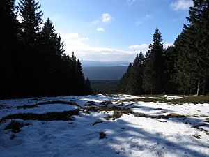
View from the Erdbeerkopf through the aisle of the former ski slope to the south-southwest. |
||
| height | 847.7 m above sea level NHN | |
| location | at Schierke ; District of Harz , Saxony-Anhalt ( Germany ) | |
| Mountains | Harz ( Upper Harz ; High Harz ) | |
| Coordinates | 51 ° 46 '26 " N , 10 ° 40' 43" E | |
|
|
||
The strawberry head is 847.7 m above sea level. NHN high side knoll of the Hohnekamm in the Harz low mountain range near Schierke in the Harz district of Saxony-Anhalt .
Geographical location
The strawberry head extends in the upper resin (high resin) within the natural parks resin / Saxony-indication in the National Park resin . It is located around 1.5 km northeast of the village of Schierke on the Kalten Bode , a district of the city of Wernigerode , whose core city is around 10 km northeast, and just under 3.5 km north-northwest of Elend , a district of the town of Oberharz am Brocken .
In a north-northwest direction, the landscape of the Erdbeerkopf leads to the Renneckenberg (approx. 933 m ) with the Brocken to the west of it ( 1141.1 m ) and in the northeast to the Hohnekamm ( 900.6 m ). The south-southwest neighboring dome is the Barenberg ( 695.5 m ). To the west-southwest, beyond Schierke, lies the mountain range of Wurmberg ( 971.2 m ), Großem Winterberg ( 906.4 m ) and Kleinem Winterberg ( 837 m ).
There are several rock formations on the mountain - these are sorted alphabetically: to the west is the Ahrentsklint , on the south flank the Feuersteinklippe , on the southeast flank the Kesselklippe and east-southeast the Trudenstein .
The Wormke rises northwest of the Erdbeerkopf and flows north and northeast in the transition area to the Hohnekamm and flows southeast to the Kalten Bode ; The artificially created Wormsgraben branches off from the Wormke east of the mountain and runs mainly eastwards to the Zillierbach .
Brocken Railway
On the southeast, south and southwest slopes of strawberry head which opened in 1898 runs Brockenbahn , a narrow-gauge railway to 19.0 km long route from Drei Annen Hohne by the south of the mountain located station Schierke northwestward leads to the Brocken.
Hiking, ex-ski slope and opportunities for a view
There are two paths leading to the wooded strawberry head, one from the east and one from the west. On the south-west slope there is a forest-free swath that was previously used as a ski slope . Remains of an old ski lift can still be seen there. Despite its accessible location, the mountain is rarely climbed. There is a wooden bench at the top. From there you can overlook part of the southern Harz via the aisle .

