
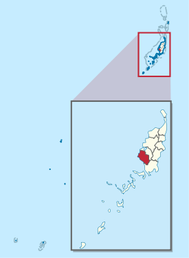
Aimeliik
| Aimeliik | |
|---|---|

|
|
| geography | |
| Country: | Palau |
| Waters: | Pacific Ocean |
| Islands: | Babelthuap |
| Geographical location: | 7 ° 25 ′ N , 134 ° 31 ′ E |
| Basic data | |
| Surface: | 52 km² |
| Residents: | 334 |
| Population density: | 6 inhabitants / km² |
| Capital: | Mongami |
| Situation map | |
  |
|

Aimeliik is an administrative state (i.e. an administrative area ) of the West Pacific island republic of Palau and is located in the southwest of the main island of Babelthuap . The main town of the administrative area is Mongami . The Palauian sub-state, consisting of the villages (hamlets) Imul , Ngerkeai , Chelechui (Elechui), Ngchemiangel and Medorm , has 334 inhabitants (as of 2015).
The landscape is predominantly characterized by mountainous land and jungle. Aimeliik borders the Airai administrative region to the southeast and Ngatpang to the northeast .