
Airai
| Airai | |
|---|---|

|
|
| geography | |
| Country: | Palau |
| Waters: | Pacific Ocean |
| Islands: | Babelthuap and some offshore islands |
| Geographical location: | 7 ° 29 ′ N , 134 ° 38 ′ E |
| Basic data | |
| Surface: | 44 km² |
| Residents: | 2455 (2015) |
| Population density: | 56 inhabitants / km² |
| Capital: | Airai or Ordomel |
| Situation map | |
  |
|
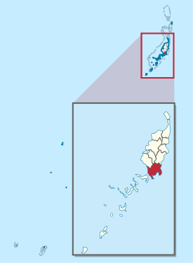
Airai is an administrative part of the state (ie an administrative area ) of the West Pacific island republic of Palau .
The 44 km² area consists of six villages (hamlets) and occupies the south of the main Palau island of Babelthuap as well as some offshore islands in the southeast and in 2005 had 2723 inhabitants. The main town is the village of Airai on the south coast, also called Ordomel or Irrai, with about 600 inhabitants (as of 2004). Other villages are Ngetkib, Ngeruluobel and Ngerusar in the southwest and Ngchesechang and Oikull in the east of the state.
The international airport of Palau, which is now called Roman Tmetuchl International Airport , is also located in the administrative area of Airai .
A 1000 meter long roadway leads from Ngetkib to the south-west bordering island of Koror along with an approximately 200 meter long bridge ( Japan-Palau Friendship Bridge ).
Web links
- Official website ( Memento of January 24, 2012 in the Internet Archive ) (English)