Kayangel (Palau)
| Kayangel | |
|---|---|

|
|
| geography | |
| Country: | Palau |
| Waters: | Pacific Ocean |
| Islands: | Atolls and Velasco Reef |
| Geographical location: | 8 ° 7 ′ N , 134 ° 40 ′ E |
| Basic data | |
| Surface: | 1.41 |
| Residents: | 54 (2015) |
| Population density: | 38 inhabitants / km² |
| Capital: | Kayangel |
| Situation map | |
Kayangel ( Ngcheangel ) is the northernmost state of the Pacific island republic of Palau and is located about 72 km north of Ngerulmud , the capital of Palau.
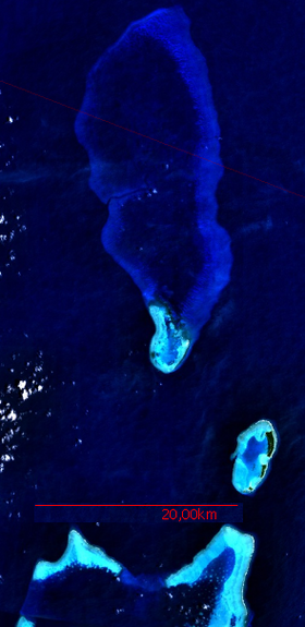
The Palauian state with a total land area of around 1.41 km 2 is made up of the following atolls and coral reefs :

Velasco Reef
in the north, Ngaruangel Reef in the middle,
Kayangel Atoll on the lower right,
and the northern barrier reef of Babelthuap below
![]() Map with all coordinates: OSM | WikiMap
Map with all coordinates: OSM | WikiMap
| Atoll / reef | Land (km²) | Lagoon (km²) | Geographic coordinates (geographic location) |
| Kayangel | 1.39 | 20th | 8 ° 4 ' N , 134 ° 42' E |
| Ngaruangel | 0.02 | 15th | 8 ° 10 ' N , 134 ° 38' E |
| Velasco Reef | --- | 330 | 8 ° 20 ' N , 134 ° 37' E |
Only the Kayangel Atoll is inhabited; In 2005, around 188 people lived on the island of Kayangel of the same name .
The Ngaruangel Reef is a nascent atoll about 10 km northwest of the Kayangel Atoll, and separated from it by the Ngaruangl Passage , a very deep and 8 km wide passage. The reef has a bare and uninhabited small island (area 1.5 ha) of the same name, which lies on the eastern rim of the reef. The Ngaruangel Reef is a protected area.
The Velasco Reef is a sunken atoll 26 km north of the Ngaruangl Reef; most of the reef is not mapped , however .
Others
The Palau Parliament passed a joint resolution in January 2005 supporting a 2002 agreement between Kayangel State and Palau Pacific Energy Inc. (PPE) giving the oil company exclusive rights to explore, drill and produce oil in the surrounding marine area for a specified period of time is granted. Originally, the Palau government declined to do so on environmental grounds, but then bowed to a 2003 petition from residents of Kayangel State calling for exploration.
Web links
- PUB. 126, SAILING DIRECTIONS (ENROUTE), PACIFIC ISLANDS . (PDF file; 567 kB)
- Satellite images
- Kayangel State Constitution
- CUSTOMARY MARINE TENURE AND TRADITIONAL ECOLOGICAL KNOWLEDGE IN PALAU (Kayangel and Ngarchelong ), (PDF file; 5400 kB)
- Augustin Krämer: Palau. Division III: Settlements, Districts, Villages, Constitution. Division IV: Demography, Anthropology, Language. Friederichsen, Hamburg 1919 , pp. 40–45
- USGS Topographic Map Sheet Ngcheangel 1: 25,000

