Kayangel (Atoll)
| Kayangel Atoll | ||
|---|---|---|
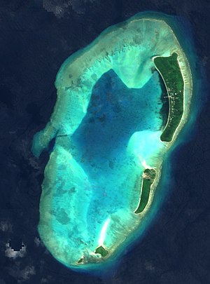
| Satellite image of the atoll | ||
| Waters | Pacific Ocean | |
| archipelago | Palau Islands | |
| Geographical location | 8 ° 4 ′ N , 134 ° 42 ′ E | |
|
|
||
| Number of islands | 4th | |
| Main island | Kayangel | |
| Land area | 1.39 km² | |
| Lagoon area | 5.9 km² | |
| Residents | 138 (2002) | |
| Map of the Kayangel Atoll | ||
The Kayangel Atoll (also: Ngcheangel ) is located in the north of the Pacific island republic of Palau , about 64 km north of the capital Melekeok . Administratively, the atoll belongs to the Palau state of the same name, Kayangel .
The atoll measures 3.7 km from north to south and is 2 km wide, with a total area of approximately 6 km² including the lagoon . This is an average of 6 m and a maximum of 9.6 m deep. Around 25 large coral columns can be made out on aerial photographs. On the west side of the atoll there is a narrow opening ( Ulach Boat Pass ) through which boats can pass into the lagoon.
Kayangel has four forested islands along the eastern and southern reef rim , of which only the island of Kayangel ( Ngajangel ) in the northeast is inhabited. The other islands in the atoll, including Ngeriungs , Ngerebelas and Orak, are not inhabited.


