Dongosaro
| Dongosaro | ||
|---|---|---|
| Southern tip of Dongosaro | ||
| Waters | Pacific Ocean | |
| Archipelago | Sonsorol Islands | |
| Geographical location | 5 ° 19 '34 " N , 132 ° 13' 14" E | |
|
|
||
| length | 1.8 km | |
| width | 700 m | |
| surface | 1.36 km² | |
| Highest elevation | 1 m | |
| Residents | 24 (2000) 18 inhabitants / km² |
|
| main place | Dongosaro | |
| NASA satellite image of Fanna and Dongosaro (bottom) | ||
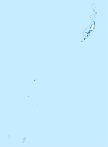
Dongosaro , also known as Sonsorol or Dongosaru , is an island in the western Pacific . It is 1.7 km south of its smaller sister island Fanna, with which it forms the group of the Sonsorol Islands .
The island is surrounded by a coral reef that is 160 to 480 m from land. The main settlement of the same name, Dongosaro, is located on the west coast of the island, which is heavily forested with coconut palms .
Together with the islands of Fanna, Pulo Anna and Merir , Dongosaro forms the Palauian state Sonsorol , d. H. an administrative area of the island republic of Palau.


