Ulebsechel
| Ulebsechel | ||
|---|---|---|
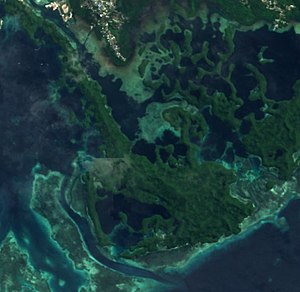
| Satellite image of Ulebsechel (center) | ||
| Waters | Ngerikuul Bay , Pacific Ocean | |
| Archipelago | Ulebsechel Islands | |
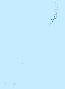
| Geographical location | 7 ° 19 ′ N , 134 ° 29 ′ E | |
|
|
||
| length | 4.8 | |
| width | 2.2 | |
| surface | 4 km² | |
| Residents | uninhabited | |
Ulebsechel (also: a Ulapsagel , Auluptagel , Aurapushekaru , Chulebsechel , Oluksakel , Oropushakari-tō , Oropusharakaru To , Ulupsael ) is an island in the island state of Palau in the Pacific Ocean .
geography
The name of the island is also used as a name for the Ulebsechel Islands in the Rock Islands area . The island is immediately south of Koror and is only separated from it by Ngerikuul Bay . In some places the waterway is only a few meters wide. The coastline is characterized by mangroves and the rugged structure of the former reef crown . Numerous bays and headlands form a confusing mosaic. In the south, towards the Omekang Reef , the island fans out and to the north stretches a long narrow strip of land, which is only separated from the adjacent island of Ngermalk to the north by the narrow Ongelunge Channel . To the south, the Toachel ra Ngel (Geru-suido, Ngel-Einfahrt, Ngell Channel) separates the island from the reef in the area of the Ngederrak Reef Conservation Area . Many smaller islands adjoin the island. In Ngerikuul Bay these are Iberor Islets , Kuat , Ngellang , Bukrrairong , Ngerbechetei Islets , Ngetkuml , Ngerumetochel , Ngedesakr , Tengetcheyangel , Toirius , Ngertechiel , Meduu , as well as Ngerchebukl and Ucheliungs . The island is densely forested and not permanently inhabited.
Individual evidence
literature
- Republic of Palau Adventure and Dive Guide. Guide to the undisputed Best Diving in the World. Franko Maps Ltd. 2016.

