Old care field
|
Old care field
City of Dahme / Mark
Coordinates: 51 ° 49 ′ 10 ″ N , 13 ° 31 ′ 45 ″ E
|
||
|---|---|---|
| Height : | 138 m above sea level NHN | |
| Incorporation : | July 1, 1961 | |
| Incorporated into: | Kemlitz | |
| Postal code : | 15936 | |
| Area code : | 035451 | |
|
Location of Altsorgefeld in Brandenburg |
||
|
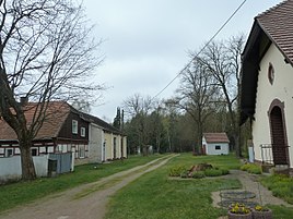
Village street and hunting lodge
|
||
Altsorgefeld is part of the municipality of Kemlitz in the town of Dahme / Mark in the Teltow-Fläming district in Brandenburg .
history
Altsorgefeld was founded in the 18th century by the Lebusa rule as a Vorwerk. The historic town center comprised eleven farmsteads, an inn, the village school and the Simson country house.
After the Congress of Vienna , the former electoral Saxon rule Lebusa and thus also Altsorgenfeld belonged to the Kingdom of Prussia .
As an independent municipality, Altsorgefeld belonged to the Schweinitz district until 1950 . The responsible district court was in Schlieben , the responsible tax office in Herzberg an der Elster and the nearest post office in Hohenbucko . In 1925 the place still had 44 inhabitants, in 1933 already 66 inhabitants, by the end of the war the number of inhabitants rose to 117. Under the post-war Soviet administration , the village was assigned to the Luckau district in April 1950 and, with the establishment of the GDR, to the Cottbus district and its newly formed Luckau district . In July 1961, Altsorgefeld was incorporated into Kemlitz. Altsorgefeld has belonged to the town of Dahme / Mark in the district of Teltow-Fläming since 1990 as part of the Kemlitz community.
geography
Altsorgefeld is located in the Rochauer Heide in a glacial Elbarm valley , west to the Niederlausitzer Grenzwall and east to the Niedere Fläming .
Web links
- Kemlitz with Altsorgefeld on the website of the Dahme / Mark office

