Amphoe Mae Tha (Lamphun)
|
Mae Tha แม่ทา |
|
|---|---|
| Province: | Lamphun |
| Surface: | 762.6 km² |
| Residents: | 39,415 (2013) |
| Population density : | 52.9 U / km² |
| ZIP : | 51170, 51140 |
| Geocode : | 5102 |
| map | |

|
|

Amphoe Mae Tha ( Thai อำเภอ แม่ทา , pronunciation: ʔāmpʰɤ̄ː mɛ̂ː tʰāː ) is a district ( amphoe - administrative district) in the northeast of Lamphun Province . The Lamphun Province is located in the northern region of Thailand .
geography
Neighboring districts are (from the south clockwise) Amphoe Thung Hua Chang , Ban Hong , Pa Sang and Mueang Lamphun Province Lamphun, Mae On the Chiang Mai Province , and Mueang Lampang , Hang Chat and OEM Ngam the province of Lampang .
Part of Doi Khun Tan National Park (Thai: อุทยานแห่งชาติ ดอย ขุน ตาล ) is located in Mae Tha County, while the larger part is in the western part of Lampang Province. The 255 km² park was opened in 1975 as the tenth national park in Thailand .
history
Mae Tha was founded in 1939 as a "branch circle " ( King Amphoe ) , consisting of tambon that were split off from Mueang Lamphun County . On July 22, 1958, the subdistrict was given full amphoe status.
traffic
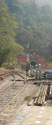
Thailand's longest railway tunnel, the Khun Tan Tunnel , is located on the northern line of the Thai Railway between the two railway stations Mae Tan Noi (Amphoe Mae Tha) and Khun Tan ( Amphoe Hang Chat , Lampang ). The tunnel is 1362 meters long and passes under the Khun Tan mountain range . The work on the Khun Tan Tunnel was directed by the German engineer Emil Eisenhofer. When Eisenhofer died very old in 1962, he was buried at the northern exit of the Khun Tan tunnel.
administration
Provincial Administration
Mae Tha County is divided into six tambon ("subdistricts" or "parishes"), which are further subdivided into 71 muban ("villages").
| No. | Surname | Thai | Muban | Pop. |
|---|---|---|---|---|
| 1. | Tha Pla Duk | ทา ปลา ดุก | 15th | 7,424 |
| 2. | Tha Sop Sao | ทาส บ เส้า | 16 | 10,383 |
| 3. | Tha Kat | ทา กา ศ | 16 | 7,781 |
| 4th | Tha Khum Ngoen | ทา ขุม เงิน | 12 | 6,778 |
| 5. | Tha Thung Luang | ทา ทุ่ง หลวง | 6th | 3,886 |
| 6th | Tha Mae Lop | ทา แม่ ลอบ | 6th | 3.163 |
Local administration
There are seven municipalities with "small town" status ( Thesaban Tambon ) in the district:
- Tha Pla Duk (Thai: เทศบาล ตำบล ทา ปลา ดุก ) consisting of the complete tambon Tha Pla Duk.
- Tha Kat Nuea (Thai: เทศบาล ตำบล ทา กา ศ เหนือ ) consisting of parts of the Tambon Tha Kat.
- Tha Khum Ngoen (Thai: เทศบาล ตำบล ทา ขุม เงิน ) consisting of parts of the Tambon Tha Khum Ngoen.
- Tha Thung Luang (Thai: เทศบาล ตำบล ทา ทุ่ง หลวง ) consisting of the complete Tambon Tha Thung Luang.
- Tha Kat (Thai: เทศบาล ตำบล ทา กา ศ ) consisting of the parts of the Tambon Tha Kat, Tha Khum Ngoen.
- Tha Sop Sao (Thai: เทศบาล ตำบล ทาส บ เส้า ) consisting of parts of the Tambon Tha Sop Sao.
- Tha Sop Chai (Thai: เทศบาล ตำบล ทาส บ ชัย ) consisting of parts of the Tambon Tha Sop Sao.
There is also a " Tambon Administration Organization " ( องค์การ บริหาร ส่วน ตำบล - Tambon Administrative Organization, TAO)
- Tha Mae Lop (Thai: องค์การ บริหาร ส่วน ตำบล ทา แม่ ลอบ ) consisting of the complete tambon Tha Mae Lop.
Individual evidence
- ↑ พระราชกฤษฎีกา จัดตั้ง อำเภอ กระสัง อำเภอ กระนวน อำเภอ บางกอกใหญ่ อำเภอ ขุน หาร อำเภอ พนา อำเภอ ปากช่อง อำเภอ วังเหนือ อำเภอ วัง ชิ้น อำเภอ แม่ทา อำเภอ หนอง หมู อำเภอ สระแก้ว สระแก้ว อำเภอ อมก๋อย อำเภอ บางซ้าย บางซ้าย อำเภอ ทับสะแก อำเภอ บุณฑริก อำเภอ ลานสะกา อำเภอ จอมบึง อำเภอ ท่ายาง อำเภอ สามเงา อำเภอ อำเภอ ชานุมาน บ้านเขว้า บ้านเขว้า บ้านเขว้า บ้านเขว้า บ้านเขว้า บ้านเขว้า อำเภอ แม่พริก อำเภอ ท่าสองยาง อำเภอ สะเมิง อำเภอ หนองแขม อำเภอ พระแสง พ.ศ. ๒๕๐๑ . In: Royal Gazette . 75, No. 55 ก , July 22, 1958, pp. 321-327.
- ↑ 2013 population statistics ( Thai ) Department of Provincial Administration. Retrieved October 27, 2014.
Web links
- More information on Amphoe Mae Tha from amphoe.com (in Thai)
- Information on Doi Khun Tan National Park (in English)
Coordinates: 18 ° 28 ' N , 99 ° 8' E

