Amphoe Mueang Nonthaburi
|
Mueang Nonthaburi เมืองนนทบุรี |
|
|---|---|
| Province: | Nonthaburi |
| Surface: | 77.01 km² |
| Residents: | 358.006 (2013) |
| Population density : | 4591.3 U./km² |
| ZIP : | 11000 |
| Geocode : | 1201 |
| map | |

|
|
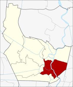
Amphoe Mueang Nonthaburi ( Thai อำเภอ เมืองนนทบุรี }, pronunciation: ʔāmpʰɤ̄ː mɯ̄aŋ nōntʰáʔbūrīː ) is a district ( Amphoe - administrative district) in the southeast of the province of Nonthaburi . The Nonthaburi Province is located in the central region of Thailand .
geography
Nonthaburi is located 20 kilometers north of the state capital Bangkok on the Mae Nam Chao Phraya (Chao Phraya River) .
Amphoe Mueang Nonthaburi borders the following counties (clockwise from the south): the Amphoe Bang Kruai , Bang Yai , Bang Bua Thong and Pak Kret in Nonthaburi Province and the ( Khet ) Lak Si , Chatuchak and Bang Sue districts of Bangkok .
Amphoe Mueang Nonthaburi is traversed by the Mae Nam Chao Phraya, the most important river in central Thailand. It divides the district into a very densely populated eastern part, which is completely occupied by the city ( Thesaban Nakhon ) Nonthaburi (almost three quarters of the district's population live here), and a more suburban western part.
history
Mueang Nonthaburi County was originally called Talat Khwan, but it is uncertain when it was established. In 1917 the provincial administration of Nonthaburi was transferred to this district, since then it has been called Mueang Nonthaburi. From January 1, 1943 to May 9, 1946, the district was part of the capital Bangkok and was simply renamed Nonthaburi. After the province was re-established, the name was changed back to Mueang Nonthaburi.
religion
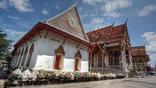
- Wat Chaloem Phra Kiat
- Wat Khema Phirataram
- Wat Prasat
- Wat Chomphuwek
- Wat Chotikaram
- Wat Khang Khao
- Wat Pak Nam Nonthaburi
- Wat Tamnak Tai
- Wat Pa Lelai (abandoned)
traffic
The far east of Amphoe Mueang Nonthaburi is traversed by the Sirat Expressway , a toll road for northern Bangkok traffic. Another important road is Ngam Wong Wan Road (National Road 302), which connects Nonthaburi with Bangkok's Chatuchak district. In a westerly direction, National Road 302 is called Rattanathibet Road and leads to Ratchaphruek Road and Kanchanaphisek Road ( Outer Bangkok Ring Road ). The Tiwanon Road (National Road 306) runs north to neighboring Pak Kret . Its southern continuation, Phibunsongkhram Street, leads into the Bang Sue district of Bangkok.
The riverside parts of Amphoe Mueang Nonthaburi can be reached by Chao Phraya express boats. These have five piers on the east side (Phibunsongkhram 1, Wat Khema, Phibunsongkhram 2, Nonthaburi / Phibunsongkhram 3 and Krasuang Phanit (Ministry of Commerce)) and two piers on the west (Wat Tuek, Wat Kian).
Amphoe Mueang Nonthaburi does not have a railway station. However, since 2016 it has been connected to the capital's mass transport system by the purple line of the Bangkok Metro (MRT). This establishes a connection between the Nonthaburi province and the existing blue line.
There are three road bridges over the Chao Phraya in the area of Amphoe Mueang Nonthaburi: The Phra Nang Klao Bridge, completed in 1985, and the Rama V Bridge (Saphan Phra Ram 5) further downstream, opened in 2002 . To relieve the Phra Nang Klao Bridge, another six-lane bridge was opened in 2008 directly parallel to it; together they now form a kind of double bridge. Another crossing between Phra Nang Klao and Rama V, which is designed as a six-lane extradosed bridge , is to be opened at the end of 2014. As part of the MRT expansion, a bridge for the new rapid transit system is also being built. This will be built next to the two existing Phra Nang Klao bridges and therefore has the project name Phra Nang Klao 3 .
Government and justice
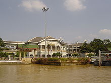
The Thai Ministry of Commerce and Health are located in Amphoe Mueang Nonthaburi.
This district is also home to the Bang Kwang Central Men’s Prison , which has a reputation for particularly harsh prison conditions and is known by Western foreigners under the cynical nickname “Bangkok Hilton”.
administration
Provincial Administration
Mueang Nonthaburi County is divided into ten tambon ("subdistricts" or "parishes"), which are further subdivided into 70 muban ("villages").
| No. | Surname | Thai | Muban | Pop. |
|---|---|---|---|---|
| 1. | Suan Yai | สวน ใหญ่ | - | 36,591 |
| 2. | Talat Khwan | ตลาด ขวัญ | - | 50,449 |
| 3. | Bang Khen | บางเขน | - | 41,633 |
| 4th | Bang Kraso | บาง กระ สอ | - | 54,455 |
| 5. | Tha Sai | ท่าทราย | - | 73,490 |
| 6th | Bang Phai | บางไผ่ | 5 | 9,935 |
| 7th | Bang Si Mueang | บางศรีเมือง | - | 23,259 |
| 8th. | Bang Krang | บาง กร่าง | 10 | 27,167 |
| 9. | Sai Ma | ไทร ม้า | 6th | 21.002 |
| 10. | Bang Rak Noi | บางรัก น้อย | 6th | 20,025 |
Note: Some of the Muban's data are not yet available.
Local administration
There is one commune with "big city" status ( Thesaban Nakhon ) in the county:
- Nonthaburi (Thai: เทศบาล นคร นนทบุรี ) consisting of the complete tambon Suan Yai, Talat Khwan, Bang Khen, Bang Kraso, Tha Sai.
There is one commune with "city" status ( Thesaban Mueang ) in the district:
- Bang Si Mueang (Thai: เทศบาล เมือง บางศรีเมือง ) consisting of the complete Tambon Bang Si Mueang and parts of the Tambon Bang Krang.
There is one municipality with "small town" status ( Thesaban Tambon ) in the district:
- Sai Ma (Thai: เทศบาล ตำบล ไทร ม้า ) consisting of the complete tambon Sai Ma.
There are also three " tambon administration organizations " ( องค์การ บริหาร ส่วน ตำบล - Tambon Administrative Organizations, TAO)
- Bang Phai (Thai: องค์การ บริหาร ส่วน ตำบล บางไผ่ ) consisting of the complete Tambon Bang Phai.
- Bang Krang (Thai: องค์การ บริหาร ส่วน ตำบล บาง กร่าง ) consisting of parts of the Tambon Bang Krang.
- Bang Rak Noi (Thai: องค์การ บริหาร ส่วน ตำบล บางรัก น้อย ) consisting of the complete tambon Bang Rak Noi.
Individual evidence
- ↑ พระราชกฤษฎีกา เปลี่ยน ชื่อ อำเภอ บาง แห่ง พุทธศักราช ๒๔๘๖ Royal Gazette, Volume 60, Ed. 3 ก v. January 12, 1943, pp. 103-105 (in Thai)
- ↑ พระราชกฤษฎีกา เปลี่ยน ชื่อ อำเภอ บาง แห่ง พ.ศ. ๒๔๘๙ Royal Gazette, Volume 63, Ed. 63 ก v. September 28, 1946, pp. 486-488 (in Thai)
- ↑ 2013 population statistics ( Thai ) Department of Provincial Administration. Retrieved August 8, 2014.
Web links
- More information on Amphoe Mueang Nonthaburi from amphoe.com (in Thai). Archived from the original on July 12, 2007 ; accessed on July 28, 2015 .
Coordinates: 13 ° 52 ' N , 100 ° 31' E


