
Amruthapura
| Amruthapura | |||
|---|---|---|---|
|
|||
| State : |
|
||
| State : | Karnataka | ||
| District : | Chikmagalur | ||
| Location : | 13 ° 44 ' N , 75 ° 51' E | ||
| Height : | 693 m | ||
| Residents : | 856 (2011) | ||
 |
|||


Amruthapura or Amrutapura is a village with about 850 inhabitants in the Chikmagalur district in the southwestern Indian state of Karnataka . The place is known for its Hoysala Temple, built around 1196 .
location
Amruthapura lies on the Dekkan Plateau at an altitude of approx. 695 m above sea level. d. M. approx. 65 km (driving distance) north of the district capital Chikmagalur or approx. 25 km southeast of Bhadravati . The nearest train station is in Tarikere, approx. 10 km away . Because of the altitude, the climate is rather moderate by Indian standards; Rain falls mainly during the monsoon months May to October.
population
The rural population, mostly speaking Kannada , consists almost without exception of Hindus ; Muslims and other religions are numerically small minorities. The male and female proportions of the population are roughly the same.
economy
The people of Amruthapura live largely as farmers. While in earlier times the business was almost exclusively self-sufficient, other sales markets have been added as the transport options have improved. The fields in the area mainly grow wheat , lentils and vegetables. Even coconut trees play an important role in the economy of the region.
history
Amruthapura was already an important place in the Hoysala Empire in the Middle Ages . In the 15th and first half of the 16th century, the area was part of the Vijayanagar Empire, in 1690 it came under the control of the princely state of Mysore , whose rule, however, in the second half of the 18th century by Hyder Ali (r . 1761–1782) and his son Tipu Sultan (r. 1782–1799) was interrupted. After that, the British played the dominant military and economic role in South India.
Attractions
_facing_the_sanctum_in_the_Amrutesvara_temple_at_Amruthapura.JPG)
The Lakshmi Devi Temple, built around 1196 and mostly made of soapstone , is the foundation of a wealthy military man at the court of the Hoysala ruler Vira Ballala II (ruled approx. 1173–1220); it is dedicated to the Hindu god Shiva , but in the cella ( garbhagriha ) there is also a stone image of the locally revered goddess Sharadha Devi . The temple, which is raised by a stepped tower ( vimana ) with a final 'umbrella dome' and a vase ( kalasha ), follows the older one-cella type ( ekakuta ); It has two vestibules ( mandapas ), the exterior of which is designed in a very idiosyncratic manner: its roof, consisting of large stone slabs and surrounded by a richly decorated, almost crenellated parapet, rests on several undecorated basalt pillars which, at intervals, support the outer skin of the Enclose the porch. Inside the temple there is a lying Nandi bull, Shiva's companion animal ( vahana ), as well as the characteristic turned soapstone columns of the Hoysala architecture ; the ceiling segments contain richly decorated cantilever domes with hanging keystones ( hangers ).

Battle scene

War scene from the Mahabharata (?)
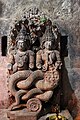
Naga king and queen

Cantilever dome with hanger


literature
- Gerard Foekema: Hoysala Architecture: Medieval Temples of Southern Karnataka built during Hoysala Rule. Books & Books, New Delhi 1994, ISBN 978-81-8501-641-2 .
- Gerard Foekema: Complete Guide to Hoysala Temples. Abhinav Publ., New Delhi 1996, ISBN 81-7017-345-0 .
- S. Settar: The Hoysala Temples. Kala Yatra Publ., Bangalore 1992, ISBN 978-81-9001-721-3 .
Web links
- Amruthapura, temple - photos + information (Wikipedia, English)
- Amruthapura, Temple - Photos + Info (English)
- Amruthapura, Temple - Photos + Info (English)