
Aperous low
| Aperous low | ||
_-_2.jpg) Aper Tief (at Holtgast) |
||
| Data | ||
| Water code | EN : 3884 | |
| location | Ammerland district and Leer district , Lower Saxony , Germany | |
| River system | Ems | |
| Drain over | Jümme → Leda → Ems → North Sea | |
| origin | Confluence of the Großer Süderbäke and Großer Norderbäke 53 ° 13 ′ 3 ″ N , 7 ° 47 ′ 34 ″ E |
|
| Source height | 2 m above sea level NN | |
| muzzle | south of Detern in the Jümme coordinates: 53 ° 12 ′ 19 ″ N , 7 ° 40 ′ 40 ″ E 53 ° 12 ′ 19 ″ N , 7 ° 40 ′ 40 ″ E
|
|
| length | 8.5 km | |
| Left tributaries | Nordloher Canal | |
| Right tributaries | Hengstford pump trench, Augustfehn Canal | |
| Small towns | Apen, Augustfehn, Detern | |
| Communities | Apen, Jümme municipality | |
The Aper Tief is a small river in the Lower Saxon communities of Apen in the Ammerland district and Detern in the Jümme district in the Leer district . It begins west of Apen at the confluence of the Große Süderbäke and the Große Norderbäke, runs roughly in an east-west direction and joins the Jümme south of the municipality of Detern .
The Aper Tief was channeled and expanded around 1845.
The Aper Tief is subject to the tides . The tidal range is about three quarters of a meter.
There are three retention areas at Aper Tief , which serve as flood protection. By relocating the dike on the left side, unregulated retention areas were created at Augustfehn and Vreschen-Bokel. At Augustfehn there is a retention area of around 1 million m³ on around 75 hectares. The area at Vreschen-Bokel is around 45 hectares. The two retention areas are subject to natural water dynamics and thus serve nature conservation. The area near Augustfehn is designated as a nature reserve " Aper Tief ", the area near Vreschen-Bokel is part of the nature reserve " Vreschen-Bokel am Aper Tief ". A regulated relief polder is connected to these two retention areas with the Polder Detern-Ore-Lowland .
The Aper Tief is crossed by bridges in four places: at Augustfehn, Vreschen-Bokel, Holtgast and Detern. At Augustfehn, the low was crossed by a bascule bridge, the Staaßenbrücke. The bridge was replaced in the early 1990s and moved to the Augustfehn Canal where it flows into the Aper Tief.
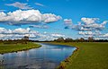
Aper Tief, Ammerland district
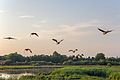
Wild geese over the dike in Hengstforde / Apen


literature
- Helge Bormann et al .: Nature-like design of floodplains - the “Aper Tief” dike. In: Wasser und Abfall , 6/2011, pp. 19–26 ( online ).
- Richard Eckhoff, Hilke Hinrichs: The Aper Tief is allowed to leave the bed again. In: gewässer-info , No. 53, January 2012, pp. 569–571.
Web links
Individual evidence
- ↑ Aper Tief - water description. Fischereiverein Stickhausen e. V., accessed on February 5, 2018 .
- ↑ The Aper Tief can get out of bed again. (PDF, 5.1 MB) (No longer available online.) Ammerland district and Ammerländer Wasseracht, July 24, 2007, archived from the original on April 9, 2018 ; accessed on April 9, 2018 . Info: The archive link was inserted automatically and has not yet been checked. Please check the original and archive link according to the instructions and then remove this notice.
- ↑ Dike Aper Tief. Ammerländer Wasseracht water and soil association, accessed on February 5, 2018 .
- ↑ Dike area at Aper Tief in Vreschen-Bokel. In: NZW-Online . Retrieved February 5, 2018 .
- ↑ The Staaßenbrücke on the Aper Tief. (No longer available online.) Ammerland-Touristik, Ammerland district, archived from the original on February 6, 2018 ; accessed on February 5, 2018 . Info: The archive link was inserted automatically and has not yet been checked. Please check the original and archive link according to the instructions and then remove this notice.